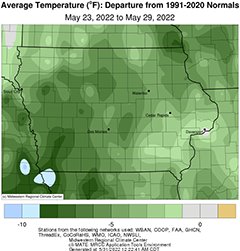
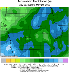
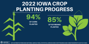
DES MOINES, Iowa—Iowa Secretary of Agriculture Mike Naig commented today on the Iowa Crop Progress and Condition Report released by the USDA National Agricultural Statistics Service. The report is released weekly April through November.“Recent rainfall across the state has helped to push the crop along as farmers are approaching the end of planting,” said Secretary Naig. “Short-term outlooks, through the first week of June, show better chances of rainfall paired with cooler temperatures.”The weekly report is also available on the USDA’s website at nass.usda.gov.Crop ReportA few days of welcome rainfall meant Iowa farmers had 4.1 days suitable for fieldwork during the week ending May 29, 2022, according to the USDA, National Agricultural Statistics Service. Fieldwork activities included planting, cutting hay, and applying chemicals.Topsoil moisture conditions rated 1 percent very short, 10 percent short, 80 percent adequate and 9 percent surplus. Subsoil moisture conditions rated 2 percent very short, 18 percent short, 74 percent adequate and 6 percent surplus.Planting is almost complete, with 94 percent of Iowa’s expected corn crop planted, 13 days behind last year but equal to the 5-year average. Seventy-three percent of the corn crop has emerged, 6 days behind last year and 2 days behind the average. Iowa’s first corn condition rating of the crop year was 0 percent very poor, 1 percent poor, 13 percent fair, 71 percent good and 15 percent excellent. Eighty-five percent of soybeans have been planted, 11 days behind last year but 6 days ahead of the 5-year average. Forty-five percent of soybeans have emerged, 8 days behind last year and 1 day behind the average. Ninety percent of the oat crop has emerged, 11 days behind last year and 1 week behind the 5-year average. Ten percent of the oat crop has headed, 5 days behind last year. Iowa’s oat condition improved to 82 percent good to excellent.Fifteen percent of the State’s first cutting of alfalfa hay has been completed. Hay condition improved to 75 percent good to excellent. Pasture condition rose to 63 percent good to excellent. Pastures and hay growth were good as rains replenished soil moisture. Pastures are in good shape for livestock.Weather SummaryProvided by Justin Glisan, Ph.D., State Climatologist, Iowa Department of Agriculture and Land StewardshipUnseasonably cool temperatures were observed at most of Iowa’s stations over the reporting period with departures of up to eight degrees below normal in southwestern Iowa. The statewide average temperature was 59.2 degrees, 4.1 degrees below normal. Widespread rainfall along with isolated severe weather was also reported. Much of the state experienced normal to above-average rainfall with only northwestern Iowa observing precipitation deficits approaching 0.50 inch below average.A northwesterly wind held daytime temperatures in the low to mid 60s across Iowa through Sunday (22nd) afternoon with mostly sunny skies. Winds shifted to the east overnight into Monday (23rd) with morning temperatures hovering in the low 30s at several stations in northeastern Iowa; upper 40s were observed in southern Iowa where patchy cloud cover was present. Afternoon conditions were pleasant with highs in the low to mid 60s with a few passing clouds in the southwest. Light easterly winds persisted into Tuesday (24th) as cumulus clouds began to envelop the state from south to north. These thicker clouds held morning temperatures in the low to mid 50s as the sun rose. A shield of light to moderate rainfall lifted north through the afternoon hours ahead of a low pressure disturbance moving out of Kansas and northwestern Missouri. The low pressure center had a wide extent and continued to filter in showers and a few isolated severe-warned thunderstorms into central and eastern Iowa through Wednesday (25th) evening. Heavier rain was reported across a wide swath with event rain totals at or above 1.00 inch at more than 250 of Iowa’s reporting stations with 32 stations measuring 2.00 inches or more. The low’s center stalled out over Missouri and Illinois, spinning in additional showers to southeastern Iowa through much of Thursday (26th). Overnight lows ranged from the mid 40s west to upper 50s east with afternoon highs not rebounding much under thick clouds and rainfall.High pressure took control of the region on Friday (27th) as skies cleared. Sunshine and light winds helped push daytime highs in the low to mid 70s for most locations with mid 80s in the northwest. A southerly shift in the wind kept overnight lows in the mid 50s to mid 60s as isolated thundershowers popped up just before sunrise on Saturday (28th) in north-central Iowa. Additional showers formed in central Iowa and raced east as a strong pressure gradient produced very gusty southerly winds. Rainfall was measured across much of northern Iowa, though totals were generally under a tenth of an inch. Aided by clear skies, temperatures rose into the 80s with mid 90s reported in northwestern Iowa; the statewide average high was 84 degrees, eight degrees above normal. An outflow boundary from storms over the Dakotas fired a small cluster of severe thunderstorms in extreme northwest Iowa during the early morning hours of Sunday (29th). The line expanded farther south, moving over western Iowa and leaving behind a few tenths of an inch of rainfall as well as vivid lightning strikes. Rockwell City (Calhoun County) reported 0.20 inch while Elma (Howard County) measured 0.48 inch at the 7:00 am observation cut-off.Weekly precipitation totals ranged from 0.11 inch at Keokuk Municipal Airport (Lee County) to 2.90 inches at Hampton (Franklin County). The statewide weekly average precipitation was 1.25 inches while the normal is 1.14 inches. Spencer Municipal Airport (Harrison County) reported the week’s high temperature of 95 degrees on the 28th, 20 degrees above normal. Elkader (Clayton County) reported the week’s low temperature of 30 degrees on the 23rd, 18 degrees below normal. As of Sunday, four-inch soil temperatures were in the upper 60s and low 70s statewide.


