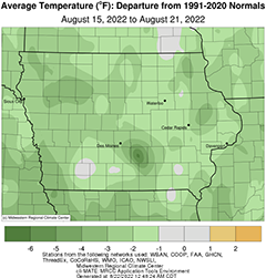
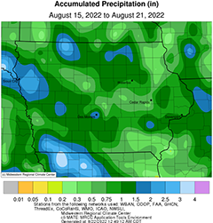
DES MOINES, Iowa—Iowa Secretary of Agriculture Mike Naig commented Monday on the Iowa Crop Progress and Condition Report released by the USDA National Agricultural Statistics Service. The report is released weekly April through November.“Iowa experienced cooler temperatures and much-needed rainfall over the final week of the State Fair,” said Secretary Naig. “While showers and thunderstorms brought heavier totals across the drought region, we need several months of above-average precipitation to relieve the most intense drought conditions. The rain received last week was welcomed as stressed soybeans continue to set and fill pods.”The weekly report is also available on the USDA’s website at nass.usda.gov.Crop ReportWidespread rain across the State resulted in 5.2 days suitable for fieldwork during the week ending August 21, 2022, according to the USDA, National Agricultural Statistics Service. Fieldwork included harvesting corn for silage, cutting hay, and applying pesticides.Topsoil moisture condition rated 18 percent very short, 30 percent short, 50 percent adequate and 2 percent surplus. Thanks to widespread rain during the week, less than half of the topsoil is considered short to very short compared to 53 percent a week ago. Subsoil moisture condition rated 21 percent very short, 33 percent short, 44 percent adequate and 2 percent surplus.Corn silking or beyond was 97 percent with 84 percent of the corn crop in dough stage or beyond, 5 days behind last year but 2 days ahead of the 5-year average. Thirty percent of Iowa’s corn crop has reached the dent stage, 5 days behind last year and 1 day behind average. Some of the corn crop has started to mature at 1 percent. Corn condition remained 66 percent good to excellent. Ninety-seven percent of soybeans were blooming with 88 percent of the soybean crop setting pods, 8 days behind last year and 2 days behind the 5-year average. Two percent of the soybeans were turning color. Iowa’s soybean condition was 62 percent good to excellent. Oats harvested for grain reached 91 percent, 8 days behind last year and 10 days behind the average.Fifty-three percent of the State’s third cutting of alfalfa hay was complete. All hay condition rose slightly to 48 percent good to excellent. Pasture condition rated 33 percent good to excellent. Grasshoppers are a concern in some areas.Weather SummaryProvided by Justin Glisan, Ph.D., State Climatologist, Iowa Department of Agriculture and Land StewardshipUnseasonably cool conditions greeted Iowa throughout the State Fair’s final week of festivities. Temperatures were anywhere from one to four degrees below normal with a statewide average temperature of 69.2 degrees, 2.9 degrees below normal. A more active storm track also brought widespread rainfall statewide with above-average totals, on the order of two to three inches, across parts of the western drought region; this was the first reporting period since early July to have above-average statewide rainfall.Cloud cover temporarily decreased over western Iowa through Sunday (14th) afternoon as another weather disturbance approached. Daytime temperatures held in the low 80s southwest with low to mid 70s across the rest of Iowa. Rain showers moved into northwestern Iowa through the evening hours before a more widespread shield of showers and thunderstorms pushed in overnight and for the majority of Monday (15th). Clouds and rain held daytime temperatures in the 60s in western Iowa while low to mid 70s were found in eastern Iowa where skies were mostly sunny. Slow-moving thunderstorms formed in southwestern Iowa into the late night and early morning hours of Tuesday (16th). Measurable rain fell over much of Iowa’s southwestern two-thirds with event totals over 0.20 inch for most stations; more than 20 stations measured at least an inch with Shenandoah (Page County) reporting 2.23 inches and a statewide average of 0.39 inch. Winds shifted to an easterly direction as skies partially cleared through the afternoon with highs reaching into the upper 70s and low 80s. Clear skies and light winds led to a chilly and foggy start on Wednesday (17th) with morning lows in the mid to upper 50s at most stations; the statewide average low was 57 degrees, five degrees below normal. Pleasant conditions persisted through the day with upper 70s and low 80s under partly cloudy skies.Starry skies were visible into Thursday (18th) as a light southerly wind developed. Morning lows were in the mid to upper 50s with patchy fog at some stations. Winds swinging to the southwesterly direction increased relative humidity as a fall-like low pressure center pushed into northwestern Iowa. Strong to severe thunderstorms formed along the low’s attendant cold front into the evening as high temperatures pushed into the 80s; heavier downpours were reported in stronger storms with localized reports of tennis ball-sized hail in Sioux County. The line continued southeast into central Iowa before losing steam into Friday (19th) morning over the southeast. Rain totals at 7:00 am were heaviest in northwest and north-central Iowa with 1.04 inches at Iowa Falls (Hardin County) and 2.58 inches at Estherville Municipal Airport (Emmet County). Many stations measured between 0.25-0.75 inch with lighter totals east. The low center continued to spin in spotty thunderstorms for the rest of the day over much of the state. A fast-developing severe thunderstorm fired directly over the Des Moines (Polk County) metro around 2:30 pm, producing an extremely isolated pocket of golf to tennis ball-sized hail in West Des Moines and Clive; this hail event produced damage to multiple vehicles, schools and retail stores as well as heavy rain and vivid lightning at the Iowa State Fairgrounds. Several other severe thunderstorms formed later in the evening over eastern Iowa. Most of Iowa’s stations observed measurable rainfall with higher totals under stronger and slow-moving cells; several Des Moines stations reported from 1.68 to 2.46 inches. The low continued to move across the Great Lakes into Saturday (20th) producing enough localized atmospheric spin to create funnel clouds in eastern Iowa. Temperatures held in the 70s statewide as rain showers diminished into Sunday (21st) morning. Several eastern stations measured totals from 0.55 inch at Le Claire Lock and Dam (Scott County) to 1.18 inches in DeWitt.Weekly precipitation totals ranged from 0.14 inch in Mount Pleasant (Henry County) to 3.42 inches in Estherville (Emmet County). The statewide weekly average precipitation was 1.12 inches while the normal is 0.91 inch. Several southeastern Iowa stations reported the week’s high temperature of 88 degrees on the 19th, on average five degrees above normal. Knoxville (Marion County) reported the week’s low temperature of 50 degrees on the 17th, 13 degrees below normal.


(contributed press release)


