DES MOINES, Iowa—Iowa Secretary of Agriculture Mike Naig commented today on the Iowa Crop Progress and Condition Report released by the USDA National Agricultural Statistics Service. The report is released weekly April through November.
“Several rounds of showers and thunderstorms continued to bring beneficial rains to locations that have missed out on summer rainfall,” said Iowa Secretary of Agriculture Mike Naig. “Longer breaks between rainfalls have allowed farmers to continue chopping silage and baling hay. Initial seasonal outlooks for fall indicate warmer and drier conditions, which would be helpful for dry down and harvest activities.”
The weekly report is also available on the USDA’s website at nass.usda.gov.
Crop Report
Rain across most of the State resulted in 5.5 days suitable for fieldwork during the week ending August 28, 2022, according to the USDA, National Agricultural Statistics Service. Fieldwork included harvesting corn for silage and cutting hay.
Topsoil moisture condition rated 16 percent very short, 29 percent short, 53 percent adequate and 2 percent surplus. Despite recent rains, over half of topsoil was considered short to very short on moisture in the Northwest, West Central, Southwest, South Central and Southeast Districts. Subsoil moisture condition rated 20 percent very short, 33 percent short, 45 percent adequate and 2 percent surplus.
Corn in the dough stage or beyond was 92 percent, 3 days behind last year but 2 days ahead of the 5-year average. Fifty-two percent of Iowa’s corn crop has reached the dent stage or beyond, 4 days behind last year. Three percent of the State’s corn crop was mature, 1 week behind last year and 4 days behind the 5-year average. Corn condition remained 66 percent good to excellent. Ninety-five percent of soybeans were setting pods, 6 days behind last year but 2 days ahead of the average. Soybeans were coloring at 7 percent, 5 days behind last year and 3 days behind the 5-year average. Soybean condition rated 63 percent good to excellent. Oats harvested for grain reached 93 percent, almost 2 weeks behind last year and 15 days behind the average.
Sixty-five percent of the State’s third cutting of alfalfa hay was complete. Pasture condition rated 31 percent good to excellent. Some pastures were still stressed from lack of precipitation.
Weather Summary
Provided by Justin Glisan, Ph.D., State Climatologist, Iowa Department of Agriculture and Land Stewardship
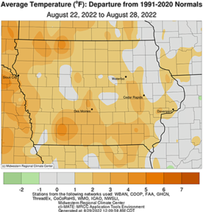
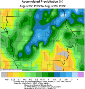
A continued active storm track brought widespread rainfall across Iowa during the reporting period; positive departures of two to three inches were found over a swath from the state’s southwest corner through northeastern Iowa. Temperatures were also near-seasonal to a few degrees warmer than normal with a statewide average of 71.6 degrees, 0.5 degree above normal.
A high pressure center parked over the Midwest brought pleasant conditions to Iowa with partly sunny skies and daytime temperatures in the mid 70s to low 80s through Sunday (21st) afternoon. Winds were very light to calm overnight into Monday (22nd) leading to dense fog and heavy surface dew during the morning hours with lows in the mid to upper 50s. Partly cloudy skies persisted into the afternoon with variable winds and seasonal highs in the upper 70s and low 80s. Clouds increased though the nighttime hours and into Tuesday (23rd) as winds picked up in northwestern Iowa ahead of low pressure system. Southerly winds gradually built in with afternoon temperatures ranging from the upper 80s northwest to upper 70s northeast. Overnight lows cooled into the low to mid 60s as an isolated line of thundershowers pushed into northwestern Iowa early on Wednesday (24th) morning ahead of a cold front. Winds swung around to a northerly direction as the front dropped south over Iowa through the afternoon, holding high temperatures in the upper 70s and low 80s north of the front; upper 80s and some low 90s were observed in southern Iowa. Isolated storms fired along the boundary into the evening, becoming more numerous in eastern Iowa after midnight. An additional wave formed in western Iowa just before sunrise but fizzled out during late Thursday (25th) morning. Event rain totals were highest at eastern and southwestern stations with many locations reporting at least 0.20 inch; Red Oak (Montgomery County) measured 1.00 inch while Clinton (Clinton County) observed 2.08 inches.
Clouds hung around for most of the day with temperatures varying from the upper 70s northwest to mid 80s southeast. Foggy conditions formed in eastern Iowa early Friday (26th) as spotty showers redeveloped in the southwest with a handful of stations reporting minor totals. Clouds thinned through the day as southeasterly winds brought in more moisture ahead of the next disturbance to impact Iowa. Temperatures remained warmer than average as the sun rose on Saturday (27th) with upper 60s and low 70s west and low to mid 60s east. A north-south oriented stationary front set up later in the muggy afternoon hours as highs pushed into the upper 80s and low 90s. Ample moisture flow into the atmospheric boundary forced sluggish thunderstorms with locally heavy rain rates from southwestern Iowa through central and northeastern Iowa. Initial storm development brought several severe-warned storms to eastern Iowa and then farther west before the cells consolidated into a widespread rain shield. The disturbance persisted past midnight as it slowly pushed east. Rainfall totals at 7:00 am showed more than 50 stations measuring at least an inch, 24 of which were at or above two inches across a narrow swath from Adams to Story County; most stations receiving rain had at least 0.40 inch with the statewide average coming in at 0.86 inch.
Weekly precipitation totals ranged from no accumulation at several southeastern Iowa stations to 3.50 inches in Story City (Story County). The statewide weekly average precipitation was 0.95 inch while the normal is 0.97 inch. Osceola (Clarke County) reported the week’s high temperature of 93 degrees on the 24th, 10 degrees above normal. Anamosa (Jones County) reported the week’s low temperature of 50 degrees on the 25th, eight degrees below normal.


