DES MOINES, Iowa—Iowa Secretary of Agriculture Mike Naig commented Monday on the Iowa Crop Progress and Condition Report released by the USDA National Agricultural Statistics Service. The report is released weekly April through November.
“Fall has officially arrived, cooler temperatures are starting to settle in, and combines are rolling in corn and soybean fields across the state,” said Iowa Secretary of Agriculture Mike Naig. “Despite some triple digit readings in places last Tuesday, the first frost of the season looks possible for portions of Iowa this week.”
The weekly report is also available on the USDA’s website at nass.usda.gov.
Crop Report
Farmers took advantage of 5.5 days suitable for fieldwork to get harvest underway during the week ending September 25, 2022, according to the USDA, National Agricultural Statistics Service. Fieldwork included harvesting row crops, chopping silage, and cutting hay.
Topsoil moisture condition rated 14 percent very short, 29 percent short, 56 percent adequate and 1 percent surplus. Subsoil moisture condition rated 20 percent very short, 30 percent short, 49 percent adequate and 1 percent surplus.
Corn in the dent stage or beyond was 97 percent, 1 week ahead of the 5-year average. Sixty-three percent of Iowa’s corn crop was mature or beyond, 2 days behind last year but 1 day ahead of the average. Harvest of the State’s corn crop was 5 percent complete, 5 days behind last year and 1 day behind the 5-year average. Corn condition remained 64 percent good to excellent. Ninety percent of soybeans were coloring or beyond, 3 days behind last year. Soybeans dropping leaves or beyond were at 61 percent, 3 days behind last year and 1 day behind the 5-year average. Soybean harvest reached 7 percent, 4 days behind last year and 3 days behind the average. Soybean condition rated 62 percent good to excellent.
Ninety-eight percent of the State’s third cutting of alfalfa hay was complete. Pasture condition rated 34 percent good to excellent.
Weather Summary
Provided by Justin Glisan, Ph.D., State Climatologist, Iowa Department of Agriculture and Land Stewardship
Fall officially started during the reporting period with the first half of the week experiencing unseasonably hot temperatures; the statewide average temperature was 64.6 degrees, 6.0 degrees above normal. Conditions moderated towards the end of the week as a large-scale low-pressure center traversed Iowa bringing generally light rainfall statewide.
Spotty showers and thunderstorms formed during late Sunday (18th) afternoon with several cells becoming severe prior to and after sunset. Several reports of 2.5-inch hail were found between Iowa City (Johnson County) and Davenport (Scott County); hail over an inch in diameter was also found in Lee County. Several stations within these swaths also measured rainfall totals from 0.50 inch to 2.00 inches at Oskaloosa (Mahaska County). Winds were out of the northeast on Monday (19th) morning as foggy conditions developed over portions of northern Iowa with lows varying from the upper 60s south to low 50s north. A southerly shifting wind helped boost afternoon highs into the mid to upper 80s in western Iowa as cloud cover in eastern Iowa held temperatures up to ten degrees cooler. Skies remained generally cloudless on Tuesday (20th) as a strong area of high pressure built in through the day. Daytime highs were exceedingly above average, hovering in the mid to upper 90s, with readings in the low 100s at several stations. Numerous records for the day were tied or broken with a statewide average high of 94 degrees, 19 degrees above normal. Temperatures dove overnight as a cold front swept southeast through Iowa with lows behind the front in the upper 50s and low 60s; low 70s were observed in southeast Iowa with spotty showers popping. Rain totals reported on Wednesday (21st) morning were highest in the southeast counties where a few tenths were observed at multiple stations, though Mount Pleasant (Henry County) measured 0.71 inch from multiple rounds of showers. Additional showers formed over southern Iowa from the afternoon into the evening hours with temperatures holding in the upper 60s and low 70s.
Clouds cleared north to south overnight into Thursday (22nd) with morning lows dropping into the upper 30s and low 40s where stars were visible. Rain totals for the previous 24 hours were mostly under 0.10 inch with a few stations in Lee County reporting the highest totals; Donnellson registered 0.20 inch while 0.62 inch was observed at West Point. Afternoon conditions were mostly sunny and pleasant as high temperatures settled in the low to mid 60s. Clouds increased in western Iowa as widespread showers spread north to south. Wet and chilly weather persisted through Friday (23rd) with steady rain and patchy drizzle as daytime highs remained in the 50s. Showers pushed out of southeastern Iowa into the early hours of Saturday (24th). Event rain totals were in the range of 0.10 to 0.25 inch at many stations with locally heavier totals in north-central Iowa; Emmetsburg (Palo Alto) and Swea City (Kossuth County) both observed 0.46 inch. Fog burned off through the morning with afternoon temperatures from the mid 80s southwest to low 70s northeast. Clear skies continued into Sunday (25th) with morning lows in the lower 50s.
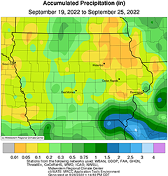
Weekly precipitation totals ranged from trace amounts at several stations to 2.64 inches at Keokuk Lock and Dam (Lee County). The statewide weekly average rainfall was 0.25 inch while the normal is 0.76 inch. Little Sioux (Harrison County) reported the week’s high temperature of 102 degrees on the 20th, 26 degrees above normal. Knoxville (Marion County) and Sibley (Osceola County) reported the week’s low temperature of 38 degrees on the 22nd, on average 11 degrees below normal.


(contributed press release)


