DES MOINES, Iowa—Iowa Secretary of Agriculture Mike Naig commented today on the Iowa Crop Progress and Condition Report released by the USDA National Agricultural Statistics Service. The report is released weekly April through November.
“Soybean harvest is beginning to wrap up and Iowa farmers and are making big strides toward finishing corn harvest,” said Secretary Naig. “While the persistently dry conditions have helped push harvest progress along, moderate drought continues to spread statewide and is now covering nearly half of Iowa.”
The weekly report is also available on the USDA’s website at nass.usda.gov.
Crop Report
Row crop harvest remained ahead of average as Iowa’s farmers had 6.7 days suitable for fieldwork during the week ending October 23, 2022, according to the USDA, National Agricultural Statistics Service. Fieldwork included harvesting row crops, fall tillage, and applying fall fertilizer. Dry conditions resulted in some field fires being reported during harvest.
Topsoil moisture condition rated 28 percent very short, 43 percent short, 29 percent adequate and 0 percent surplus. Subsoil moisture condition rated 28 percent very short, 44 percent short, 28 percent adequate and 0 percent surplus.
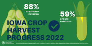
Nearly all of Iowa’s corn crop has reached the mature stage or beyond. Harvest of the corn for grain crop reached 59 percent complete, 1 day ahead of last year and 8 days ahead of the average. The percent of corn harvested varied by area of the State with just 38 and 39 percent harvested in northeast and south central Iowa, respectively, and 82 percent harvested in northwest Iowa. Moisture content of field corn being harvested for grain was 18 percent. Corn condition rated 65 percent good to excellent. Soybeans harvested reached 88 percent complete, 11 days ahead of the average.
Pasture condition rated 26 percent good to excellent. Dry conditions were an issue for cattle.
Weather Summary
Provided by Justin Glisan, Ph.D., State Climatologist, Iowa Department of Agriculture and Land Stewardship
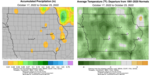
An unseasonably cool and dry weather pattern took hold over the Midwest through most of the reporting period with negative temperature departures of up to seven degrees across portions of Iowa; the statewide average temperature was 45.7 degrees, 3.8 degrees below normal. While several eastern Iowa stations reported trace amounts of rainfall, only a few National Weather Service co-op stations observed measurable totals. Overall, statewide precipitation deficits were on the order of 0.40 inch to 0.60 inch.
Blustery northwesterly winds continued through Sunday (16th) afternoon as clouds cleared from west to east. A dome of high pressure and an unseasonably cold airmass ushered in mid 40s into northwestern Iowa while upper 50s were registered in the southeast. Overnight lows into Monday (17th) were generally in the upper 20s and low 30s under clear skies. Daytime highs did not rebound appreciably as windy conditions persisted; upper 30s to low 40s were observed from north to south. Scattered cloud cover filtered into eastern Iowa along with very isolated pockets of drizzle and light rain. Morning lows on Tuesday (18th) were some of the coldest of the season with single digits reported in northwestern Iowa while temperatures farther southeast were up to 20 degrees warmer; the statewide average low was 20 degrees, 18 degrees below normal. Sunshine greeted chilly conditions through the day with afternoon highs gradually climbing into the upper 40s over Iowa’s southeastern half. Wind shifted to the west as the sun rose on Wednesday (19th) with teens to mid 20s observed west to east. Clear conditions and highs in the upper 40s to low 50s were observed through the afternoon hours with pockets of upper-level haze moving across Iowa.
A shift in the weather pattern ushered in unseasonably warm temperatures on Thursday (20th) as upper 60s and low 70s were reported at most of Iowa’s stations. A transition to southerly winds overnight into Friday (21st) held morning temperatures in the upper 30s to mid 40s over much of Iowa with a pocket of warmer readings in west-central Iowa. With cloudless skies and a south to southwesterly wind, warmth continued as daytime conditions ranged from the low 70s over northern Iowa to low 80s across Iowa’s southern one-third. The warmest day of the week dawned on Saturday (22nd) with morning lows in the mid to upper 50s in south-central Iowa, 10 to 15 degrees above average. Very windy conditions built in during the afternoon and evening hours with upper 70s to upper 80s reported statewide; the statewide average high was 82 degrees, 23 degrees above normal. Gusty southeasterly winds remained overnight with pockets of partly cloudy conditions developing. Sunday (23rd) morning lows, in the upper 50s and low 60s, were balmy as southerly moisture began to boost dewpoints in advance of a low pressure center.
Weekly precipitation totals ranged from no accumulation at most of Iowa’s reporting stations to 0.01 inch at Maquoketa (Jackson County). The statewide weekly average rainfall was a trace while the normal is 0.56 inch. Ottumwa Industrial Airport (Wapello County) reported the week’s high temperature of 87 degrees on the 22nd, 26 degrees above normal. Spencer Municipal Airport (Clay County) reported the week’s low temperature of 7 degrees on the 18th, 30 degrees below normal. Four-inch soil temperatures were in the mid 50s northeast to low 60s southwest as of Sunday.


(contributed press release, IDALS)


