DES MOINES, Iowa—Iowa Secretary of Agriculture Mike Naig commented today on the Iowa Crop Progress and Condition Report released by the USDA National Agricultural Statistics Service. The report is released weekly April through November.
“The widespread and badly needed rain during the last week did very little to slow down corn and soybean harvest, which continues at a pace well ahead of the five-year average,” said Secretary Naig. “Though the recent warmer weather has been good for both trick-or-treating and field work, a wetter forecast looks possible for the end of this week and through early November.”
The weekly report is also available on the USDA’s website at nass.usda.gov.
Crop Report
Row crop harvest was winding down ahead of normal as Iowa’s farmers had 5.9 days suitable for fieldwork during the week ending October 30, 2022, according to the USDA, National Agricultural Statistics Service. Fieldwork included harvesting row crops, completing fall tillage, applying fall fertilizer, baling stalks, and hauling manure. Field fires were reported again in some areas with continued dry conditions.
Topsoil moisture condition rated 24 percent very short, 44 percent short, 32 percent adequate and 0 percent surplus. Subsoil moisture condition rated 26 percent very short, 45 percent short, 29 percent adequate and 0 percent surplus.
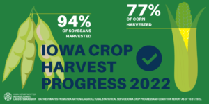
Harvest of the corn for grain crop reached 77 percent complete, 5 days ahead of last year and 9 days ahead of the average. Corn harvest in northeast and south central Iowa continued to lag behind with 58 and 59 percent complete, respectively, while 95 percent has been harvested in northwest Iowa. Moisture content of field corn being harvested for grain was 17 percent. Soybeans harvested reached 94 percent complete, 1 week ahead of last year and 10 days ahead of the average. Southwest and south central Iowa producers still had over 15 percent of their soybean crop left to harvest.
Pasture condition rated 25 percent good to excellent. Dry conditions were an issue for cattle and many producers were moving them off pasture.
Weather Summary
Provided by Justin Glisan, Ph.D., State Climatologist, Iowa Department of Agriculture and Land Stewardship
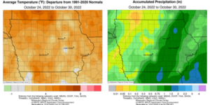
Iowa experienced the wettest reporting period since the second week of September as widespread rain fell across Iowa. Many stations from south-central to northeastern Iowa observed up to an inch above normal; western Iowa reported normal to slightly drier conditions. Unseasonably warm temperatures also covered the state with conditions up to four degrees warmer in northwestern Iowa. The statewide average temperature was 48.1 degrees, which is 1.2 degrees above normal.
Warm and blustery conditions persisted through Sunday (23rd) afternoon as a strong low pressure system approached Iowa from the west. Southerly winds and mostly sunny skies helped boost temperatures into the upper 70s and low 80s at most Iowa stations. Several stations also registered mid to upper 80s with the statewide average high of 79 degrees, 21 degrees warmer than normal. Showers formed in eastern Iowa over the late evening hours as well as isolated strong thunderstorms in the northwest corner. The low’s attendant cold front slowly progressed west to east through Iowa on Monday (24th) with chilly conditions reported under overcast skies and moderate rainfall; afternoon highs ranged from the upper 40s northwest to low 70s southeast, where the front had not yet moved through. Skies gradually cleared overnight into Tuesday (25th) with morning lows generally in the 30s under a light westerly wind. Event rain totals were highest across a south-central to northeast swath with more the 100 stations measuring at least an inch. Totals tailed off farther west where amounts were under 0.30 inch with a pocket in northwest Iowa receiving no rainfall. A stable dome of high pressure dominated the weather pattern behind the disturbance lending to pleasant and generally dry conditions for the rest of the week. Variable winds and seasonal temperatures were reported on Wednesday (26th) with clear skies and conditions in the mid to upper 50s.
Clouds increased in western Iowa overnight into Thursday (27th) morning with pockets of spotty light rain and lows in the 40s. A shift to a southeasterly wind and sunshine over Iowa’s southeastern two-thirds held daytime highs in the mid to upper 50s. Thick clouds and showers in northwestern Iowa kept highs in the upper 40s. Several stations reported measurable totals with Sioux City (Woodbury County) measuring 0.44 inch. Foggy conditions were observed at several central and eastern Iowa stations on Friday (28th) morning as low temperatures remained in the upper 30s and low 40s. Afternoon highs pushed into the upper 50s to low 60s statewide with slightly warmer conditions in the southwest corner. Starry skies and light southeasterly winds persisted into Saturday (29th) with morning lows in the 30s. Daytime conditions were unseasonably warm with upper 60s northwest to low 60s southeast. Cloud cover was largely absent from the state overnight into Sunday (30th) with lows in the upper 30s and low 40s.
Weekly precipitation totals ranged from 0.01 inch at Estherville Municipal Airport (Emmet County) to 1.88 inches in Fayette (Fayette County). The statewide weekly average rainfall was 0.66 inch while the normal is 0.54 inch. Oskaloosa (Mahaska County) reported the week’s high temperature of 88 degrees on the 23rd, 26 degrees above normal. Spencer Municipal Airport (Clay County) reported the week’s low temperature of 20 degrees on the 26th, 13 degrees below normal. Four-inch soil temperatures were in the upper 40s north to low 50s south as of Sunday.


(contributed press release)


