DES MOINES, Iowa—Iowa Secretary of Agriculture Mike Naig commented today on the Iowa Crop Progress and Condition Report released by the USDA National Agricultural Statistics Service. The report is released weekly April through November.
“A blast of cold air late last week dropped temperatures well below normal as the first flurries of the season flew over nearly fully harvested corn and soybean fields,” said Secretary Naig. “Farmers are focused on finishing up fall field work before frost settles in as forecasts show colder conditions hanging around through the end of November.”
The weekly report is also available on the USDA’s website at nass.usda.gov.
Crop Report
Harvest was mostly complete with 5.6 days suitable for fieldwork during the week ending November 13, 2022, according to the USDA, National Agricultural Statistics Service. Fieldwork included wrapping up fall tillage, applying fertilizer, baling stalks, and hauling and spreading manure.
Topsoil moisture condition rated 18 percent very short, 35 percent short, 45 percent adequate and 2 percent surplus. Subsoil moisture condition rated 25 percent very short, 38 percent short, 36 percent adequate and 1 percent surplus.
Harvest of the corn for grain crop reached 95 percent complete, eight days ahead of last year and 12 days ahead of the average. Moisture content of field corn being harvested for grain was 16 percent. Farmers in Northeast and South Central Iowa still have over 10 percent of their corn for grain crop remaining to be harvested.
Livestock were mostly doing well, although the abrupt change to colder temperatures caused some stress.
Weather Summary
Provided by Justin Glisan, Ph.D., State Climatologist, Iowa Department of Agriculture and Land Stewardship
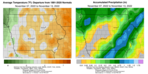
Iowans experienced a drastic shift from unseasonable warmth to winter-like conditions towards the end of the reporting period; the statewide average temperature was 39.2 degrees, 1.6 degrees above normal. Widespread rainfall and some snow flurries also brought additional moisture to soil profiles over much of the state. Eastern and northwestern Iowa reported above-average totals nearing an inch while the middle of the state saw departures nearing 0.50 inch.
Spotty cloud cover was reported across portions of Iowa through Sunday (6th) afternoon as a weak low pressure center propagated along the Iowa-Missouri border. Daytime temperatures held in the 50s as southwesterly winds shifted to more of a westerly direction. Overnight skies were clear with morning lows ranging from the low 20s north to mid 30s south. Monday (7th) was chilly with afternoon highs remaining in the low 40s over northern Iowa while southern Iowa registered temperatures in the low 50s. Clouds gradually increased through the late night hours as an easterly wind persisted, though gradually turning to the southeast as a disturbance approached northwestern Iowa. Morning lows on Tuesday (8th) were near average as clouds prevented more overnight cooling; mid to upper 40s were observed in western Iowa while upper 30s were present in eastern Iowa where skies were still clear. Showers and a few thunderstorms formed over northwestern Iowa throughout the day as gusty southeasterly winds developed statewide. Beneficial rain totals were observed across several northwestern counties with two stations in Le Mars (Plymouth County) measuring from 1.00 inch to 1.20 inches; totals tailed off farther southeast with nearly 30 stations dumping out at least 0.25 inch. Thick cloud cover held on overnight as a warmed airmass pushed into the Midwest along with higher relative humidity. Morning lows reported at 7:00 am on Wednesday (9th) in western Iowa were in the upper 50s with some low 60s ahead of a cold front approaching Iowa; these readings were up to 30 degrees warmer than normal with a statewide average low of 43 degrees, 13 degrees above normal. Low clouds and muggy conditions persisted into the afternoon and evening hours.
Southerly winds increased ahead of the cold front sweeping across Iowa on Thursday (10th). Showers and thunderstorms formed in eastern Iowa where daytime highs reached into the upper 70s. Showers expanded over Iowa’s southeastern quarter though the rest of day and overnight into Friday (11th). More than 20 stations observed at least an inch with general totals of between 0.20 to 0.60 inch at most stations reporting rainfall; Dubuque (Dubuque County) measured 1.06 inches while a gauge near Lisbon (Linn County) observed 1.49 inches. Cold Canadian air filtered in behind the cold front with afternoon highs on Saturday (12th) hovering in the 20s to low 30s; the statewide average high was 28 degrees, 20 degrees below normal. Snow flurries fell over much of Iowa through the day as northwesterly winds and thick stratus clouds persisted. Winds became variable overnight into Sunday (13th) with temperatures only dropping by five to 10 degrees with peeks of clear skies southwest. Light snow accumulations were reported at a handful of stations with 0.1 inch at Orange City (Sioux County) to 1.0 inch in Waterloo (Black Hawk County).
Weekly precipitation totals ranged from no accumulation at many western Iowa stations to 1.72 inches near Wellman (Washington County). The statewide weekly average precipitation was 0.31 inch while the normal is 0.47 inch. Several eastern Iowa stations reported the week’s high temperature of 78 degrees on the 9th, on average 26 degrees above normal. Forest City (Winnebago County) reported the week’s low temperature of 11 degrees on the 12th, 15 degrees below normal. Four-inch soil temperatures were in the mid 30s west to low 40s east as of Sunday.


(contributed press release, IDALS)


