DES MOINES, Iowa—Iowa Secretary of Agriculture Mike Naig commented today on the Iowa Crop Progress and Condition Report released by the USDA National Agricultural Statistics Service. The report is released weekly April through November. Additionally, the Iowa Department of Agriculture and Land Stewardship provides a weather summary each week during this time.
“Wetter conditions and cooler temperatures over the past week slowed down planters across much of Iowa,” said Secretary Naig. “As farmers look for a window to resume planting, other fieldwork activities including fertilizer application and cover crop termination continues.”
The weekly report is also available on the USDA’s website at nass.usda.gov.
Crop Report
Colder temperatures and a variety of precipitation limited farmers to 2.5 days suitable for fieldwork during the week ending April 23, 2023, according to the USDA, National Agricultural Statistics Service. Much needed rain in the western part of Iowa helped to improve State level moisture supplies. Corn, soybean, and oat planting continued this week, although at a reduced pace due to the cold, wet weather.
Topsoil moisture condition rated 4 percent very short, 18 percent short, 74 percent adequate and 4 percent surplus. Subsoil moisture condition rated 7 percent very short, 28 percent short, 61 percent adequate and 4 percent surplus.
Ten percent of Iowa’s expected corn crop has been planted, 9 days ahead of last year but equal to the 5-year average. Five percent of the expected soybean crop has been planted, 10 days ahead of last year and 3 days ahead of the average. Sixty-seven percent of the expected oat crop has been planted, 11 days ahead of last year and 4 days ahead of normal. Ten percent of the oat crop has emerged, 3 days ahead of last year. Calving continues with some cattle let out to pasture. Livestock were doing well although some lots are muddy.
Weather Summary
Provided by Justin Glisan, Ph.D., State Climatologist, Iowa Department of Agriculture and Land Stewardship
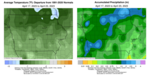
After an unseasonably warm week, temperatures headed in the opposite direction as several storm systems brought an active weather pattern and cooler conditions. Northern Iowa registered negative departures of up to ten degrees with a statewide average temperature of 44.6 degrees, 7.7 degrees below normal. All forms of precipitation were reported across Iowa with severe storms bringing hail and a few weak tornadoes along with wintery precipitation at the beginning and end of the reporting period. Iowa’s northwestern two-thirds were unseasonably wet with many stations observing over a half inch of above-average precipitation.
Chilly conditions with light snow, sleet and rain persisted through Sunday (16th) afternoon as gusty northwest winds held daytime high temperatures in the mid to upper 30s. Overnight lows did not drop appreciably as skies cleared west to east with stubborn clouds remaining over eastern Iowa. Monday (17th) temperatures rebounded into the mid to upper 50s with southwestern stations reporting low to mid 60s. Variable winds developed into Tuesday (18th), shifting to the east as the sun rose with morning lows in the upper 20s north to upper 30s south. Afternoon highs were pleasant, reaching into the mid-60s in southern Iowa, while readings were up to 10 degrees cooler in the northeast. Clouds increased through the evening as a disturbance approached Iowa producing thunderstorms in north-central and western Iowa into the early morning hours of Wednesday (19th); a few cells were severe-warned in eastern Iowa later in the morning as stratus clouds covered most of the sky statewide. A warm front lifting north in advance of a strong low-pressure system pushed temperatures into the upper 70s in southern Iowa, while north of the boundary, highs only reached into the upper 50s. Ample moisture and atmospheric instability allowed discrete supercells to fire in western Iowa along a cold front just after 5:00 pm with four reports of weak tornadoes and golf ball to tennis ball-sized hail. The storms coalesced into a line, maintaining strength into eastern Iowa into early Thursday (20th) morning.
A second complex of thunderstorms formed in southwestern Iowa and expanded across central and eastern Iowa through the day as cold air wrapped in on the backside of the low. Highs dropped into the upper 40s to mid-50s as the complex moved out of Iowa. Event totals reported at 7:00 am on Friday (21st) showed a wide swath of above average totals from southwest to northeast with smaller pockets in northwest and east-central Iowa. More than 125 stations reported at least an inch with nearly 15 stations hitting two inches or more; Corning (Adams County) measured 2.95 inches while the statewide average was 0.81 inch. Another disturbance forced light rain and snow showers through the afternoon as temperatures varied from the upper 30s northwest to mid-50s southeast. Saturday (22nd) was another unseasonably cold day as northwest winds held daytime conditions in the upper 30s and low 40s under overcast skies. Clearing clouds overnight and into Sunday (23rd) cooled lows into the 20s in western Iowa.
Weekly precipitation totals ranged from 0.14 inch at Muscatine (Muscatine County) to 3.04 inches in Winterset (Madison County). The statewide weekly average precipitation was 1.15 inches; the normal is 0.91 inch. Keokuk Lock and Dam (Lee County) reported the week’s high temperature of 81 degrees on the 19th, 17 degrees above normal. Sibley (Osceola County) reported the week’s low temperature of 20 degrees on the 23rd, 15 degrees below normal. Four-inch soil temperatures were in the low 40s north to mid to upper 40s south as of Sunday.


(contributed press release, IDALS)


