DES MOINES, Iowa—Iowa Secretary of Agriculture Mike Naig commented today on the Iowa Crop Progress and Condition Report released by the USDA National Agricultural Statistics Service. The report is released weekly April through November. Additionally, the Iowa Department of Agriculture and Land Stewardship provides a weather summary each week during this time.
“The cooler and drier conditions allowed many farmers an opportunity to get back into the fields, which led to a jump in both corn and soybeans acres planted,” said Secretary Naig. “The weather outlook suggests warmer temperatures and near-average amounts of rainfall, which should help to increase statewide planting activity and gradually reduce the flooding along the Mississippi River.”
The weekly report is also available on the USDA’s website at nass.usda.gov.
Crop Report
Cool and relatively dry weather offered farmers 4.8 days suitable for fieldwork during the week ending April 30, 2023, according to the USDA, National Agricultural Statistics Service. While planting progress continues at a decent pace, the colder than normal temperatures and dry weather have not done any favors for crop emergence. State level moisture supplies are still tightening up with the lack of precipitation. Corn, soybean, and oat planting continued this week.
Topsoil moisture condition rated 5 percent very short, 24 percent short, 68 percent adequate and 3 percent surplus. Subsoil moisture condition rated 8 percent very short, 31 percent short, 58 percent adequate and 3 percent surplus.
Twenty-nine percent of Iowa’s expected corn crop has been planted, 11 days ahead of last year but 1 day behind the 5-year average. Sixteen percent of soybeans have been planted, 11 days ahead of last year and 1 day ahead of the average. Eighty-five percent of the expected oat crop has been planted, 2 weeks ahead of last year and 6 days ahead of normal. Twenty-nine percent of the oat crop has emerged, 1 week ahead of last year and 1 day ahead of the average.
Some reports of cattle being let out to pasture were received again this week, although pasture regrowth is slow with the current weather pattern. Overall, livestock conditions continue to be good.
Weather Summary
Provided by Justin Glisan, Ph.D., State Climatologist, Iowa Department of Agriculture and Land Stewardship
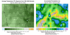
A quieter weather pattern tamped down on widespread precipitation events in Iowa through the reporting period, though a late-week disturbance produced scattered showers and thunderstorms. All of Iowa’s stations measured below-average totals with departures of an inch or more over much of the state. Cooler conditions also prevailed with temperatures ranging from four to ten degrees west to east across Iowa; the statewide average temperature was 48.0, which is 6.2 degrees below normal.
Partly cloudy skies persisted through Sunday (23rd) afternoon with high temperatures in the low 40s north to upper 40s south as winds became variable. Generally clear conditions were reported around sunrise on Monday (24th) with morning lows in the upper 20s and low 30s with areas of patchy frost in northern Iowa. Temperatures rose through the day and settled into the upper 50s and low 60s under partly to mostly cloudy skies. Several bands of rain formed across western Iowa and moved quickly southeast over the daytime hours. Multiple stations in southern Iowa measured a few tenths of an inch, though most stations picked up under 0.10 inch; a station in New London (Henry County) observed 0.38 inch.
Clouds hung around southern Iowa into Tuesday (25th) morning with clear skies north, allowing temperatures to fall near to below freezing. Skies cleared up through the day with highs generally in the 50s. Winds shifted to the east overnight and then to the southeast on Wednesday (26th) with warmer daytime conditions in the mid-50s to low 60s, under mostly sunny skies. Southerly winds kept morning lows on Thursday (27th) in the mid- to upper 40s in northern Iowa, with some northwest stations in the low 50s. Afternoon conditions were pleasant with daytime temperatures in the upper 60s to mid-70s; the statewide average high was 69 degrees, which is five degrees above normal.
Winds shifted to the northwest after midnight Friday (28th) as a cold front began sweeping east through Iowa. Light rain showers formed in western Iowa as the front advanced. High temperatures ahead of the front reached into the low to mid-70s while mid- to upper 50s were registered behind the boundary. Skies cleared west to east as rain showers tapered off into Saturday (29th) morning with rain totals at 7:00 am highest in western Iowa. Totals were in the 0.30 to 0.60-inch range with Primghar (O’Brien County) receiving 0.31 inch while 0.59 inch was observed at Logan (Harrison County).
Locations that received rain across the rest of Iowa generally measured at most a tenth or two with many stations registering a few one-hundredths. Additional showers spun in on the backside of a large low-pressure center over the Great Lakes through the afternoon and evening hours; a narrow swath of rainfall totals in the 0.25 to 0.50-inch range was found from west-central to southeast Iowa. Temperatures remained cooler where clouds and rain were present, though the upper 50s and low 60s were reported in western Iowa. Strong northwesterly winds built in early Sunday (30th) morning as cloud cover persisted in eastern Iowa with lows in the upper 30s and low 40s.
Weekly precipitation totals ranged from no accumulation at several stations across Iowa to 0.64 inch at Little Sioux (Harrison County). The statewide weekly average precipitation was 0.14 inch while the normal is 0.94 inch. Several eastern Iowa stations reported the week’s high temperature of 75 degrees on the 28th, on average nine degrees above normal. Battle Creek (Ida County), Stanley (Buchanan County) and Vinton (Benton County) reported the week’s low temperature of 20 degrees on the 24th, on average 17 degrees below normal. Four-inch soil temperatures were in the upper 40s north to low 50s south as of Sunday.


(contributed press release)


