DES MOINES, Iowa—Iowa Secretary of Agriculture Mike Naig commented Monday on the Iowa Crop Progress and Condition Report released by the USDA National Agricultural Statistics Service. The report is released weekly April through November. Additionally, the Iowa Department of Agriculture and Land Stewardship provides a weather summary each week during this time.
“Despite dry conditions, the below average temperatures over the past week provided moisture-stressed crops some relief,” said Iowa Secretary of Agriculture Mike Naig. “Though the entire state remains abnormally dry or in some level of drought, and the hottest stretch of July is forecasted this week, initial August outlooks are showing some chances for cooler and wetter conditions.”
The weekly report is also available on the USDA’s website at nass.usda.gov.
Crop Report
Another dry, but relatively cool week left Iowa farmers with 6.3 days suitable for fieldwork during the week ending July 23, 2023, according to the USDA, National Agricultural Statistics Service. Field activities included cutting hay and harvesting oats. Some reports were received of farmers applying insecticides and fungicides. Persistent dry weather has raised concerns regarding crop conditions.
Topsoil moisture condition rated 13 percent very short, 42 percent short, 43 percent adequate and 2 percent surplus. Subsoil moisture condition rated 17 percent very short, 46 percent short, 36 percent adequate and 1 percent surplus.
Corn silking hit 79 percent this week, 6 days ahead of last year and 3 days ahead of normal. Nineteen percent of the corn crop has reached the dough stage, 5 days ahead of last year and 4 days ahead of the 5-year average. Some reports were received of corn starting to dent. Corn condition rated 63 percent good to excellent. Eighty-one percent of soybeans were blooming, 1 week ahead of last year and 5 days ahead of the average. Soybeans setting pods reached 35 percent, 2 days ahead of last year and 1 day ahead of the 5-year average. Soybean condition remained steady at 58 percent good to excellent. Ninety-three percent of oats were turning color, 11 days ahead of last year and 4 days ahead of normal. Oats harvested for grain reached 36 percent, 1 day ahead of last year and 1 day ahead the five-year average. Oat condition remained 51 percent good to excellent.
The State’s second cutting of alfalfa hay reached 86 percent complete, 6 days ahead of both last year and the average. The State’s third cutting of alfalfa hay reached 20 percent complete, 12 days ahead of last year and 11 days ahead of the 5-year average. Hay condition dropped to 37 percent good to excellent. Pasture condition fell to 24 percent good to excellent. Pasture and hay growth remain slow and below average, resulting in supplemental feeding of livestock.
Weather Summary
Provided by Justin Glisan, Ph.D., State Climatologist, Iowa Department of Agriculture and Land Stewardship
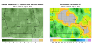
Unseasonably cool conditions continued over Iowa through the reporting period with negative temperature departures in the four to six-degree range across the state; the statewide average temperature was 69.3 degrees, 5.5 degrees below normal. The southwest corner of Iowa experienced three days of widespread and near-normal rainfall with much of north-central and east-central Iowa reporting departures of an inch or more below average. Weekend storms also brought measurable totals to the northeast corner.
Canadian wildfire smoke persisted through Sunday (16th) evening as westerly winds helped shift the flow. Afternoon highs held in the upper 70s with low 80s across much of southern Iowa. Showers and scattered thunderstorms fired over the southwestern half of the state during the early morning hours on Monday (17th) and Tuesday (18th). The first wave of thunderstorms brought several reports of hail through southern Iowa with Malvern (Mills County) reporting up to 1.50-inch hailstones; one-inch hail was observed from Lorimor (Union County) to Oskaloosa (Mahaska County). There were also multiple narrow swaths of rainfall totals above 0.30 inch over southwestern Iowa with 0.32 inch in Council Bluffs (Pottawattamie County) to 0.85 inch in Missouri Valley (Harrison County). The second round of showers clipped the southwest corner with lighter rainfall totals at a handful of stations ranging from 0.06 inch in Lamoni (Decatur County) to 0.16 inch at Hastings (Mills County). Additional showers formed over the afternoon and evening hours on Wednesday (19th) with totals at several stations under 0.10 inch.
Thursday (20th) was the ideal day of the week with daytime highs in the upper 70s and low 80s under brilliant sapphire skies. Partly cloudy conditions were reported in central Iowa, though the sun broke out as the evening wore on. Winds were no stronger than a baby’s breath into Friday (21st) morning with lows in the upper 50s to mid-60s. Afternoon conditions were near seasonal with mid-level clouds transiting the sky. Daytime temperatures were a repeat of the previous day with puffy cumulus dotting the sky. Stars were visible for much of Iowa into Saturday (22nd) morning though foggy conditions developed in northwestern Iowa. Westerly winds and low to mid-80s were observed throughout the day as mostly sunny skies reigned. The week ended with isolated thunderstorms crossing the Minnesota border into northern Iowa through the evening hours, dissipating just southwest of Jack Creek in Emmet County; additional thunderstorms developed in eastern Iowa overnight into Sunday (23rd) with a pocket of heavier rainfall in Cedar County, though amounts quickly decreased towards the Weber neighborhood in western Coralville (Johnson County). Several counties in northeast Iowa also saw widespread totals in the 0.10- to 0.50-inch range.
Weekly rain totals ranged from no accumulation across a large northwest-to-southeast swath of Iowa to 1.50 inches in Adair (Adair County). The statewide weekly average precipitation was 0.18 inch; the normal is 0.99 inch. Sioux City Airport (Woodbury County) reported the week’s high temperature of 89 degrees on the 22nd, four degrees above normal. Fayette (Fayette County) and Vinton (Benton County) reported the week’s low temperature of 48 degrees on the 18th, on average 12 degrees below normal.


(contributed press release)


