DES MOINES, Iowa—Iowa Secretary of Agriculture Mike Naig commented on the Iowa Crop Progress and Condition Report released by the USDA National Agricultural Statistics Service. The report is released weekly April through November. Additionally, the Iowa Department of Agriculture and Land Stewardship provides a weather summary each week during this time.
“Weather was mostly drier, cooler and comfortable for Iowa State Fairgoers, with the exception of a very hot final weekend,” said Secretary Naig. “Iowans should take precautions to protect themselves from the excessive heat that will cover much of the state for several more days, though a cold front is expected to bring more pleasant weather toward the end of the week.”
The weekly report is also available on the USDA’s website at nass.usda.gov.
Crop Report
Cool and dry weather throughout the state led to 6.3 days suitable for fieldwork during the week ending August 20, 2023, according to the USDA, National Agricultural Statistics Service. Field activities included cutting and baling hay as well as harvesting oats. Continued dry weather meant CRP land was opened for emergency haying and grazing.
Topsoil moisture condition rated 15 percent very short, 38 percent short, 46 percent adequate and 1 percent surplus. Subsoil moisture condition rated 19 percent very short, 44 percent short, 36 percent adequate and 1 percent surplus.
Corn in the dough stage reached 92 percent this week, 8 days ahead of last year and 10 days ahead of the 5-year average. Thirty-nine percent of the corn crop was dented, 4 days ahead of last year and 3 days ahead of normal. Corn condition rated to 60 percent good to excellent. Soybeans setting pods reached 94 percent, 1 week ahead of both last year and the average. Soybeans starting to turn color was 4 percent this week. Soybean condition rated 59 percent good to excellent. Oats harvested for grain reached 98 percent, 1 week ahead of the average.
The State’s third cutting of alfalfa hay reached 82 percent complete, 19 days ahead of last year and 16 days ahead of the average. Pasture condition rated 23 percent good to excellent. Livestock producers continued to supplement with hay due to the prolonged dry conditions, but overall livestock conditions were decent with the lower-than-average temperatures for the week.
Weather Summary
Provided by Justin Glisan, Ph.D., State Climatologist, Iowa Department of Agriculture and Land Stewardship
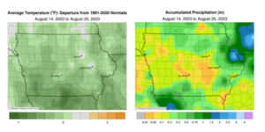
As the Iowa State Fair came to a close over the weekend, air and dewpoint temperatures began an upward climb. However, unseasonably cool conditions persisted through the reporting period with an average temperature of 68.5 degrees, 3.6 degrees below normal. Apart from a handful of stations in eastern Iowa, unseasonably dry conditions were reported statewide.
A strong low-pressure center continued to spin showers and thunderstorms across Iowa through Sunday (13th) afternoon and evening, bringing widespread rain totals. Stations in southern and northeastern Iowa collected the highest amounts, generally in the 0.50 to 0.75-inch range; two stations in Bedford (Taylor County) reported 1.05- and 1.64-inch totals with a 0.91-inch measurement in Asbury (Dubuque County). Westerly winds developed overnight with Monday (14th) morning lows in the upper 50s to mid-60s west to east across the state as light showers persisted in eastern Iowa. Moderate showers and some thunderstorms formed on the backside of the low pressure over central Iowa with a pocket of heavy rain and flash flooding along the Iowa-Wisconsin border; nine stations in Dubuque County reported totals from 1.01 inches at Dyersville to 3.20 inches at Dubuque Regional Airport. Daytime temperatures hovered in the upper 60s and low 70s with northwesterly winds building in as the disturbance pushed east. Clear skies and patchy fog were visible at sunrise on Tuesday (15th) with light winds and lows in the 50s. Upper 70s and mostly sunny skies greeted fairgoers with pleasant conditions stretching into Wednesday (16th) with gusty southerly winds, cloudless skies and highs in the low 80s. A weak cold front dropped southeast through Iowa, producing isolated thundershowers in north-central Iowa after midnight on Thursday (17th); light rain was reported at a handful of stations.
A stronger cell fired later in the morning in southeastern Iowa, bringing Columbus Junction (Louisa County) a 0.30-inch measurement. Winds shifted to the northwest as skies cleared and dewpoints dropped in the presence of a drier airmass. Low to mid-70s were observed statewide through the afternoon hours with fair weather cumulus pushing across the state. Calm winds prevailed into Friday (18th) as foggy conditions redeveloped at many stations. Afternoon temperatures rose into the upper 70s and low 80s and winds shifted to the southeast. Saturday (19th) morning temperatures were still unseasonably cool, holding in the low to mid 60s, though these readings quickly rose into the upper 80s and low 90s; the statewide average high was 90 degrees, nine degrees above normal. Very spotty showers formed in eastern Iowa with Strawberry Point (Clayton County) picking up 0.01 inch and a trace at a few other stations. Temperatures rose overnight into Sunday (20th) morning with very muggy conditions across the state; the average low was 67 degrees, seven degrees above normal; Des Moines (Polk County) reported 78 degrees, which is 14 degrees warmer than the 30-year climatological average and the warmest low temperature for the date since 1900.
Weekly precipitation totals ranged from no accumulation at several central Iowa stations to 3.43 inches in Dubuque (Dubuque County). The statewide weekly average precipitation was 0.28 inch while the normal is 0.90 inch. Sioux City Airport (Woodbury County) reported the week’s high temperature of 98 degrees on the 19th, 16 degrees above normal. Several northern stations reported the week’s low temperature of 45 degrees on the 16th and 18th, on average 13 degrees below normal.

(contributed press release, IDALS)


