DES MOINES, Iowa—Iowa Secretary of Agriculture Mike Naig commented today on the Iowa Crop Progress and Condition Report released by the USDA National Agricultural Statistics Service. The report is released weekly April through November. Additionally, the Iowa Department of Agriculture and Land Stewardship provides a weather summary each week during this time.
“While seasonal conditions have returned after last week’s sweltering heatwave, several daily records were broken across the state as a result of the hot temperatures and high humidity,” said Secretary Naig. “Those seeking to bale hay, chop silage, plant cover crops or complete other farm work may find opportunities with the hot and dry conditions that are expected to continue into September, but our crops and pastures could certainly use some badly needed rain.”
The weekly report is also available on the USDA’s website at nass.usda.gov.
Crop Report
Hot and humid weather with well below normal precipitation throughout Iowa gave farmers 6.5 days suitable for fieldwork during the week ending August 27, 2023, according to the USDA, National Agricultural Statistics Service. Field activities included cutting and baling hay as well as harvesting oats. Persistent dry weather has put continued stress on crops, especially soybeans with multiple reports of disease entering fields.
Topsoil moisture condition rated 23 percent very short, 45 percent short, 31 percent adequate and 1 percent surplus. Subsoil moisture condition rated 28 percent very short, 45 percent short, 26 percent adequate and 1 percent surplus.
Corn in or beyond the dough stage reached 96 percent this week, 8 days ahead of last year and 11 days ahead of the 5-year average. Sixty-two percent of the corn crop was dented or beyond, 5 days ahead of last year and 4 days ahead of normal. Six percent of the State’s corn crop has reached maturity. Corn condition declined 6 percentage points to 54 percent good to excellent. Soybeans setting pods reached 97 percent, 1 week ahead of last year and 9 days ahead of the average. Soybeans turning color was 15 percent this week, 2 days ahead of normal. Reports of soybeans dropping their leaves were received this week. Soybean condition dropped 6 percentage points to 53 percent good to excellent. Oats harvested for grain is nearly complete.
The State’s third cutting of alfalfa hay reached 90 percent complete, 18 days ahead of last year and 17 days ahead of the average. Pasture condition rated 23 percent good to excellent. The hot and humid weather severely stressed livestock across the State this week, with several reports of death loss.
Weather Summary
Provided by Justin Glisan, Ph.D., State Climatologist, Iowa Department of Agriculture and Land Stewardship
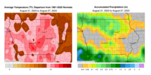
Iowans experienced the warmest reporting period of the growing season as an expansive heat dome set up over the Midwest. Stations across the state observed triple-digit air temperatures and dewpoints in the upper 70s and low 80s, creating oppressive heat index values; the statewide average temperature was 80.0 degrees, 10.1 degrees above normal. Unseasonably dry conditions persisted under the stable weather pattern with stations in west-central and eastern Iowa not receiving measurable rain totals.
Northwesterly winds persisted through Sunday (20th) afternoon as puffy stratocumulus clouds passed through much of southern Iowa. Daytime conditions varied from low 80s northwest to low to mid 90s in central and southern Iowa. Overnight lows dropped into the mid-60s to mid-70s north to south as dense fog formed before sunrise on Monday (21st). Winds gradually shifted to southerly with upper 80s and low 90s observed statewide under partly cloudy skies. Excessive Heat Warnings were issued across central Minnesota to the Gulf Coast from Tuesday (22nd) through Thursday (24th) with Iowa temperatures pushing into the mid to upper 90s as a strong and stable high-pressure center dominated the large-scale circulation. A northward shift in the jet stream also allowed ample low-level moisture to push north under the heat dome. Wednesday (23rd) was the warmest day of the heatwave with numerous daily record high and warm low temperatures broken at stations across Iowa. Morning lows started off in the 70s with pockets of dense fog; the statewide average low was 73 degrees, 14 degrees warmer than the 30-year average. Daytime conditions rapidly warmed as Iowa’s average high temperature hit 98 degrees, 17 degrees above normal. Heat index values at several stations topped 120 degrees as skies remained hazy with generally light winds.
Showers and thunderstorms pushed across northern Iowa after midnight on Friday (25th) with morning conditions noticeably less humid statewide. Additional scattered thunderstorms fired in central and southeastern Iowa into the late afternoon hours before dissipating into the evening as a cold front swept south. High temperatures varied from the mid-80s over northern Iowa, while 90s were registered across the southern counties. A secondary disturbance produced thunderstorms in southern Iowa overnight into Saturday (26th) with heavier totals reported at a handful of stations; Shenandoah (Page County) measured 0.72 inch while 1.09 inches was observed at Randolph (Fremont County). Widespread, though generally meager totals were reported at northern and south-central locations from the two disturbances; rain gauges generally collected amounts below two-tenths of an inch. Stronger northerly winds built in behind the front with comfortable highs in the mid-70s to low 80s and appreciable lower dewpoints. Partly cloudy skies remained overnight with Sunday (27th) morning lows dropping into the 50s.
Weekly rain totals ranged from no accumulation at many stations to 1.78 inches in Lake Park (Dickinson County). The statewide weekly average precipitation was 0.18 inch; the normal is 0.91 inch. Decorah (Winneshiek County) and Waterloo Municipal Airport (Black Hawk County) reported the week’s high temperature of 105 degrees on the 23rd, on average 23 degrees above normal. Waterloo began reporting observations in 1895 and the high on the 23rd broke the previous daily record of 99 degrees set in 1948. Estherville (Emmet County) reported the week’s low temperature of 49 degrees on the 27th, six degrees below normal.


(contributed press release, IDALS)


