DES MOINES, Iowa—Iowa Secretary of Agriculture Mike Naig commented Monday on the Iowa Crop Progress and Condition Report released by the USDA National Agricultural Statistics Service. The report is released weekly April through November. Additionally, the Iowa Department of Agriculture and Land Stewardship provides a weather summary each week during this time.
“With persistent hot and dry conditions, Iowa is at 166 consecutive weeks of at least moderate drought,” said Secretary Naig. “Now that Labor Day is behind us, we can expect to see farmers ramping up their pre-harvest preparations as crop conditions are variable and rain chances remain low.”
The weekly report is also available on the USDA’s website at nass.usda.gov.
Crop Report
A continued lack of precipitation throughout Iowa meant farmers had 6.8 days suitable for fieldwork during the week ending September 3, 2023, according to the USDA, National Agricultural Statistics Service. Field activities included chopping corn silage as well as cutting and baling hay. Continued drought conditions have stressed corn and soybeans and dried them out to the point that some farmers were getting equipment ready for harvest.
Topsoil moisture condition rated 33 percent very short, 42 percent short, 25 percent adequate and 0 percent surplus. Subsoil moisture condition rated 31 percent very short, 44 percent short, 24 percent adequate and 1 percent surplus. Corn in the dent stage or beyond was 78 percent this week, 5 days ahead of both last year and the 5-year average. Seventeen percent of the State’s corn crop has reached maturity, 5 days ahead of last year and 3 days ahead of normal. Corn condition declined 5 percentage points to 49 percent good to excellent. Soybeans coloring or beyond reached 40 percent, 6 days ahead of last year and 4 days ahead of the average. Soybeans dropping leaves was 8 percent this week, 1 week ahead of last year and 2 days ahead of normal. Soybean condition fell 4 percentage points to 49 percent good to excellent.
The State’s third cutting of alfalfa hay reached 95 percent complete, 16 days ahead of last year and 19 days ahead of the average. Pasture condition rated 16 percent good to excellent, the lowest rating since September 6, 2020. Hotter than normal temperatures continued to stress livestock across the State, however the reports of death loss were down this week.
Weather Summary
Provided by Justin Glisan, Ph.D., State Climatologist, Iowa Department of Agriculture and Land Stewardship
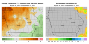
Iowa experienced its driest reporting period of the season with only a few stations observing measurable amounts. Extreme Drought (D3) now covers 18% of Iowa, the largest extent since Spring 2013. Temperatures moderated from the previous week but were still generally unseasonably warm; the statewide average temperature was 71.1 degrees, 2.0 degrees above normal.
Cooler conditions were reported across Iowa through Sunday (27th) afternoon with comfortable highs in the mid to upper 70s and light northwesterly winds. Skies were generally clear at daybreak on Monday (28th) as winds gradually shifted to the southwest with seasonal daytime highs in the low 80s. Overnight lows dropped into the mid 50s to low 60s as patchy fog formed at several locations in central and western Iowa. Low to mid 80s were reported in the afternoon hours with very spotty showers forming in extreme southeastern Iowa into Tuesday (29th) evening; Fort Madison (Lee County) observed a 0.05-inch total. Fog and hazy conditions from upper-level wildfire smoke were observed on Wednesday (30th) morning with calm to light easterly winds and temperatures in the mid to upper 50s. Daytime highs held in the upper 70s and low 80s, near average for late August; these conditions were again reported on Thursday (31st), though winds had shifted to a southeasterly direction. Morning lows observed several hours earlier were chilly in eastern Iowa with stations registering low to mid 40s, 10 to 15 degrees below normal. Clear conditions were present at sunrise on Friday (1st) with readings in the mid to upper 50s across much of the state. Stronger southerly winds built in throughout the day as highs in western Iowa rose into the upper 80s and low 90s; temperatures in eastern Iowa held in the low 80s. Overnight lows into Saturday (2nd) varied from the upper 50s east to mid 60s west with some scattered cloud cover. Afternoon temperatures quickly rose into the 90s with the warmest readings in northwestern Iowa; dewpoints remained in the low to mid 60s, creating a dry heat as the statewide average high hit 93 degrees, 14 degrees above normal. Temperatures fell back through the 60s overnight into Sunday (3rd) a light southerly wind persisted under starry skies.
Weekly precipitation totals ranged from no accumulation at nearly all of Iowa’s stations to 0.05 inch at Fort Madison. The statewide weekly average precipitation was 0.00 inch while the normal is 0.88 inch. Sioux City Airport (Woodbury County) reported the week’s high temperature of 102 degrees on the 2nd, 22 degrees above normal. Elkader (Clayton County) reported the week’s low temperature of 40 degrees on the 31st, 14 degrees below normal.


(contributed press release, IDALS)


