DES MOINES, Iowa—Iowa Secretary of Agriculture Mike Naig commented on the Iowa Crop Progress and Condition Report released by the USDA National Agricultural Statistics Service. The report is released weekly April through November. Additionally, the Iowa Department of Agriculture and Land Stewardship provides a weather summary each week during this time.
“The unseasonably warm and dry weather this past week offered Iowa farmers another suitable stretch to finish up harvest and tackle other farm work,” said Sec. Naig. “We expect warmer temperatures to hang around this week, though forecasts show a more active storm track as we approach Thanksgiving.”
The weekly report is also available on the USDA’s website at nass.usda.gov.
Crop Report
Warm, dry weather prevailed across a majority of Iowa resulting in 6.7 days suitable for fieldwork during the week ending November 12, 2023, according to the USDA, National Agricultural Statistics Service. Fieldwork included harvesting corn and soybeans, completing fall tillage, applying fall fertilizer, baling stalks, and hauling manure.
Topsoil moisture condition rated 17 percent very short, 41 percent short, 41 percent adequate and 1 percent surplus. Subsoil moisture condition rated 27 percent very short, 42 percent short, 30 percent adequate and 1 percent surplus.
Corn harvested for grain reached 94 percent statewide, on pace with last year but 10 days ahead of the 5-year average. Moisture content of field corn being harvested for grain remained steady at 16 percent. Soybean harvest is nearly complete, on pace with last year and 9 days ahead of the average.
Cattle continued to graze on stalk fields this week, while livestock producers still had concerns about water supplies.
Weather Summary
Provided by Justin Glisan, Ph.D., State Climatologist, Iowa Department of Agriculture and Land Stewardship
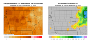
Unseasonably warm temperatures were observed across the Upper Midwest over the reporting period with positive departures approaching 10 degrees in western Iowa; the statewide average temperature was 45.0 degrees, 7.0 degrees above normal. Precipitation was also lacking across the state with stations in eastern Iowa registering measurable, but below-normal totals.
Gusty southerly winds and sunny skies boosted afternoon temperatures into the mi- 60s on Sunday (5th) afternoon. A low-pressure center moved across southern Minnesota overnight into Monday (6th) as the attendant cold front swept through Iowa, producing light rain showers in eastern Iowa. Morning lows ranged from the mid-40s north to mid-50s south with several stations reporting a trace of rainfall. Wind shifted to an east-northeasterly direction with daytime highs in the upper 50s and low 60s. Partly cloudy skies developed over portions of northern and central Iowa into Tuesday (7th) morning with temperatures holding in the 30s. Another cold front dropped across the state, firing a narrow band of showers in eastern Iowa towards the late afternoon; rain totals were under 0.20 inch with 0.12 inch in Maquoketa (Jackson County) to 0.19 inch in Davenport (Scott County) and Clinton (Clinton County). Clouds hung around into Wednesday (8th) with a northwesterly wind and highs in the upper 40s east to upper 60s southwest. Starry skies prevailed as Venus appeared next to the waning crescent Moon into Thursday (9th) with morning lows dropping into the upper 20s and low 30s. Daytime temperatures rose into the low 60s in southern Iowa while conditions were 10 degrees cooler at stations in northern Iowa. Clouds gradually increased overnight and through the day on Friday (10th) as a weak cold front transited the state, producing light rain in central and eastern Iowa. Winds were light and variable with chilly afternoon temperatures in the upper 30s north to upper 40s south. Saturday (11th) started overcast across the western three-quarters of Iowa with gusty southeasterly winds and lows ranging from the high 30s west to low 20s east where skies were clear. Upper 40s and low 50s were registered later in the day as clouds began to thin in western Iowa. Cloud cover persisted in eastern Iowa after midnight and wind speeds increased. Sunday (12th) morning began with temperatures in the 40s and generally clear conditions.
Weekly precipitation totals ranged from no accumulation at most of Iowa’s stations to 0.20 inch in Clinton. The statewide weekly average precipitation was 0.01 inch, while the normal is 0.45 inch. Several southern stations reported the week’s high temperature of 72 degrees on the 6th, on average 19 degrees above normal. Mapleton (Monona County) reported the week’s low temperature of 17 degrees on the 10th, nine degrees below normal.


(contributed press release, IDALS)


