DES MOINES, Iowa—Iowa Secretary of Agriculture Mike Naig commented on the Iowa Crop Progress and Condition Report released by the USDA National Agricultural Statistics Service. The report is released weekly April through November. Additionally, the Iowa Department of Agriculture and Land Stewardship provides a weather summary each week during this time.
“Planters have started to roll across the state with the help of a string of warm spring days,” said Secretary Naig. “However, there may be a temporary pause in planting as the forecast shows the potential for severe thunderstorms early this week followed by near-freezing low temperatures toward the weekend.”
The weekly report is also available on the USDA’s website at nass.usda.gov.
Crop Report
Dry conditions and warmer than normal temperatures helped Iowa farmers as days suitable for fieldwork increased to 4.9 for the week ending April 14, 2024, according to the USDA, National Agricultural Statistics Service. Fieldwork included tillage, spraying, applying fertilizer and seeding oats. Some corn and soybeans were also planted.
Topsoil moisture condition rated 15 percent very short, 37 percent short, 46 percent adequate and 2 percent surplus. Subsoil moisture condition rated 24 percent very short, 39 percent short, 36 percent adequate and 1 percent surplus.
Four percent of the expected corn acreage has been planted. Oats seeding reached 66 percent complete, 9 days ahead of last year and 10 days ahead of the 5-year average. Twenty percent of the expected oat acreage has emerged, almost 2 weeks ahead of last year and the average. There were still no reports of cattle being turned out into pastures.
Weather Summary
Provided by Justin Glisan, Ph.D., State Climatologist, Iowa Department of Agriculture and Land Stewardship
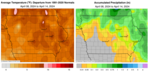
Iowans experienced unseasonably warm conditions through the reporting period with positive departures nearing 10 degrees in northern Iowa; the statewide average temperature was 53.9 degrees, 7.8 degrees above normal. While measurable rainfall was reported across most of Iowa, most stations had deficits in the 0.25- to 0.50-inch range.
A low-pressure center propagating across Nebraska pushed several waves of showers and thunderstorms into Iowa through Sunday (7th) afternoon. With enough atmospheric spin and instability, a weak tornado formed in Blairsburg (Hamilton County) causing some barn damage; the thunderstorm also produced one-inch hail in Wright County. The system exited Iowa overnight into Monday (8th) as winds shifted to the west and clouds began to clear. Widespread rainfall was observed across most of Iowa with the highest totals at northwestern and north-central stations; Lake Mills (Winnebago County) registered 0.50 inch while Milford (Dickinson County) collected 0.78 inch. Many of the state’s remaining stations had totals under 0.20 inch. Vivid blue skies dimmed as the Moon blotted out over 80% of the Sun at 1:58 pm CDT during the last total solar eclipse for the United States until 2044. Surface air temperatures cooled noticeably from the lack of incoming solar radiation but rebounded into the low 50s north to upper 60s south. Light showers reformed in northern Iowa over the evening hours with a handful of stations observing less than the 0.05-inch reading at Burt (Kossuth County). Overnight lows early on Tuesday (9th) dipped into the 30s under mostly clear skies. Afternoon temperatures held in the low to mid 60s under persistent westerly winds. A gradual shift to southerly winds into Wednesday (10th) helped boost morning lows into the mid 40s over southern Iowa as partly cloudy conditions developed through the day. Afternoon conditions were pleasant under light, variable winds and temperatures in the low 70s.
Spotty showers associated with a low-pressure center developed overnight over Iowa’s eastern two-thirds and continued through much of Thursday (11th). Gusty northwesterly winds built in through the afternoon hours with temperatures ranging from the upper 40s under rain clouds to low 60s where skies were clear. Event totals were under 0.50 inch with most stations reporting less than a tenth of an inch; eastern Iowa stations received the most moisture varying from 0.42 inch at Davenport (Scott County) to 0.47 inch at Monticello (Jones County). Starry skies returned on Friday (12th) with cloudless conditions persisting through the daylight hours. Even with gusty northwesterly winds, temperatures pushed into the mid to upper 60s statewide. A shift to southerly flow on Saturday (13th) along with ample sunshine allowed temperatures to rise into the 80s across much of Iowa; the average high was 82 degrees, 22 degrees above normal. Clear skies continued through Sunday (14th) morning with temperatures ranging from the mid 40s northwest to the low 60s southeast as high pressure dominated the Midwest.
Weekly precipitation totals ranged from no accumulation for many stations to 0.86 inch in Sibley (Osceola County). The statewide weekly average precipitation was 0.18 inch, while the normal is 0.81 inch. Spencer Municipal Airport (Clay County) reported the week’s high temperature of 89 degrees on the 13th, 31 degrees above average. Elkader (Clayton County) and Stanley (Buchanan County) reported the week’s low temperature of 28 degrees on the 13th, on average five degrees below normal. Four-inch soil temperatures ranged from the low 50s north to low 60s south as of Sunday.


(contributed press release, IDALS)


