DES MOINES, Iowa—Iowa Secretary of Agriculture Mike Naig commented on the Iowa Crop Progress and Condition Report released by the USDA National Agricultural Statistics Service. The report is released weekly April through November. Additionally, the Iowa Department of Agriculture and Land Stewardship provides a weather summary each week during this time.
“Summer heat is arriving just in time to give crops a good boost,” said Secretary Naig. “Weather outlooks into the second half of June, when farmers are completing important field applications and baling hay, indicate warmer temperatures and better chances of showers and thunderstorms.”
The weekly report is also available on the USDA’s website at nass.usda.gov.
Crop Report
Warm and drier weather throughout the State allowed Iowa farmers 4.8 days suitable for fieldwork during the week ending June 9, 2024, according to the USDA, National Agricultural Statistics Service. Planting and replanting of corn and soybeans and spraying were limited due to wet field conditions.
Topsoil moisture condition rated 0 percent very short, 5 percent short, 78 percent adequate and 17 percent surplus. Subsoil moisture condition rated 1 percent very short, 9 percent short, 77 percent adequate and 13 percent surplus.
Corn planting is nearly complete with 89 percent emerged, 9 days behind last year and 2 days behind the 5-year average. Corn condition rated at 73 percent good to excellent. Ninety-two percent of the expected soybean crop has been planted, equal to the 5-year average. Seventy-five percent of the soybean crop has emerged, 9 days behind last year and 1 day behind the average. Soybean condition rated 73 percent good to excellent. Emergence of the oat crop is nearly complete with 59 percent headed, 8 days ahead of the average. Oat condition rated to 81 percent good to excellent.
Seventy percent of the State’s first cutting of alfalfa hay has been completed, 1 week behind last year. Hay condition rated 81 percent good to excellent. Pasture condition rated 76 percent good to excellent.
Weather Summary
Provided by Justin Glisan, Ph.D., State Climatologist, Iowa Department of Agriculture and Land Stewardship
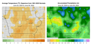
The first full reporting period of June saw less thunderstorm activity with below-normal rainfall across most of Iowa; only pockets of central and northern Iowa received above-normal totals. Temperatures were up to three degrees above normal.
Sunday (2nd) morning showers in western Iowa dissipated as they moved east into drier air. Afternoon conditions were breezy with a southerly wind pushing temperatures through the upper 70s and low 80s. Isolated thunderstorms fired in northwestern Iowa just before midnight and spread over northern Iowa into Monday (3rd); Estherville (Emmet County) collected 2.10 inches with many northwest stations reporting 0.25 to 0.75 inch of rainfall. Additional thunderstorms formed in eastern Iowa into the afternoon hours with some sluggish cells producing localized flooding. Five stations in Dubuque County registered totals ranging from 2.00 inches in Dubuque to 2.83 inches at Asbury. Daytime temperatures were in the mid to upper 80s across the western two-thirds of Iowa and in the 70s in northeast Iowa under clouds. Skies cleared overnight into Tuesday (4th) with unseasonably warm morning lows in the upper 60s with isolated low 70s from central to eastern Iowa. A strong cold front produced several severe warned thunderstorms in the afternoon as a more consolidated line developed through the evening hours. The system cleared eastern Iowa by daybreak on Wednesday (5th). More than 50 stations reported at least an inch of rainfall with heavier amounts in central and north-central Iowa; Algona (Kossuth County) measured 2.52 inches with two Dallas County locations, Waukee and Clive, registering 2.88 inches and 3.44 inches, respectively. Most stations received at least 0.30 inch with a statewide average of 0.49 inch. Westerly winds built in behind the front along with temperatures in the upper 70s and low 80s under clear skies. Isolated thundershowers formed northwest and sped to the southeast into the evening with widespread totals under 0.10 inch.
Stars were visible Thursday (6th) morning with persisting westerly winds and lows in the upper 50s and low 60s. The daylight hours were pleasant with gusty northwesterly winds and spotty clouds here and there. Temperatures varied from the low 70s northeast to low 80s southwest. Calmer conditions developed overnight with variable winds and temperatures in the 50s west to low 60s east at 7:00 am on Friday (7th). Light showers pushed into northern Iowa as strong northwesterly flow produced a complex of fast-moving thunderstorms that grazed the southwest corner of Iowa. More showers formed farther east with the highest rain totals north; Osage (Mitchell County) and Stanley (Buchanan County) observed 0.40 inch with totals tapering off to the south. Heavier showers persisted in northeastern Iowa through Saturday (8th) morning with Waterloo Municipal Airport (Black Hawk County) reporting a 0.48-inch total. Winds shifted to a northerly direction with daytime highs in the mid 60s east to upper 70s west under mostly sunny skies. Spotty rain showers moved across western Iowa, though totals were generally light. Overnight lows into Sunday (9th) held in the 50s with calm to variable, light winds under mostly clear skies.
Weekly precipitation totals ranged from 0.01 inch at several stations to 3.45 inches in Clive (Dallas County). The statewide weekly average precipitation was 0.70 inch while the normal is 1.18 inches. Pocahontas (Pocahontas County) and Shenandoah (Page County) reported the week’s high temperature of 90 degrees on the 3rd and 8th, respectively, on average 10 degrees above normal. Stanley reported the week’s low temperature of 45 degrees on the 9th, 12 degrees below normal.


(contributed press release, IDALS)


