DES MOINES, Iowa—Iowa Secretary of Agriculture Mike Naig commented on the Iowa Crop Progress and Condition Report released by the USDA National Agricultural Statistics Service. The report is released weekly April through November. Additionally, the Iowa Department of Agriculture and Land Stewardship provides a weather summary each week during this time.
“Many parts of Iowa experienced a wet start to July. Now, we’re hoping for some summer heat to provide a much-needed boost to our crops,” said Secretary Naig. “With the continued impacts of Hurricane Beryl influencing the weather pattern, forecasts indicate a calmer storm track for Iowa and increased chances of warmer temperatures over the next few weeks.”
The weekly report is also available on the USDA’s website at nass.usda.gov.
Crop Report
The south central and northeast portions of the State received heavy rains in comparison to the northwest portion of the State. These conditions only allowed Iowa farmers 3.5 days suitable for fieldwork during the week ending July 7, 2024, according to the USDA, National Agricultural Statistics Service. Concerns were expressed about getting hay put up and spraying for weeds due to frequent rain.
Topsoil moisture condition rated 0 percent very short, 4 percent short, 77 percent adequate and 19 percent surplus. Subsoil moisture condition rated 0 percent very short, 6 percent short, 77 percent adequate and 17 percent surplus.
Corn silking reached 17 percent, equal to last year but 4 days ahead of the five-year average. Corn condition was 76 percent good to excellent. Soybean crop blooming reached 32 percent, 2 days behind last year but equal to the average. Soybeans setting pods reached 5 percent. Soybean condition rated 76 percent good to excellent. Oat crop headed or beyond reached 95 percent. Oats turning color reached 63 percent, 5 days ahead of the average. Oats harvested for grain was 8 percent complete, 6 days ahead of the average. Oat condition rated 79 percent good to excellent.
The State’s second cutting of alfalfa hay reached 34 percent complete. Hay condition rated 81 percent good to excellent. Pasture condition rated 73 percent good to excellent. Feedlot conditions remain muddy due to excess precipitation and flooding.
Weather Summary
Provided by Justin Glisan, Ph.D., State Climatologist, Iowa Department of Agriculture and Land Stewardship
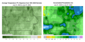
July’s first reporting period was unseasonably wet for most of Iowa with many stations observing at least 150% of normal rainfall; portions of southern and northeast Iowa were particularly wet. Clouds and rainfall helped hold down temperatures as Iowa experienced cooler than average conditions; the statewide average temperature was 69.5 degrees, 4.2 degrees below normal.
Sunday (30th) afternoon was ideal across Iowa with daytime temperatures in the low to mid 70s, light winds and sunny skies. Winds swung around to an easterly direction through Monday (1st) morning with lows in the upper 50s and low 60s east to west under increasing clouds. Light to moderate showers pushed into western Iowa and moved east through the day while eastern Iowa remained clear with highs in the low 70s; temperatures held in the 60s under clouds and rain. Showers dissipated farther east just before sunset. A secondary disturbance brought widespread showers and thunderstorms over much of Iowa’s northwestern two-thirds overnight into Tuesday (2nd). Most stations received at least 0.25 inch with nearly 80 observing at least an inch and a statewide average of 0.66 inch. Very heavy rainfall was reported from slow-moving thunderstorms across a narrow band stretching from southwest to central Iowa; Truro (Madison County) measured 2.81 inches while two stations in Mills County, Hastings and Pacific Junction, collected 4.28 and 6.10 inches, respectively. Afternoon temperatures quickly rose into the mid to upper 80s over southeastern Iowa as a warm front lifted out of Missouri ahead of a strong low pressure center. As the low’s attendant cold front slammed into the warm and unstable airmass, a line of strong to severe thunderstorms fired in central Iowa and quickly advanced east. Several storms became tornado-warned with two confirmed tornadoes near Iowa City (Johnson County) and Nichols (Muscatine County). The line exited eastern Iowa after sunset with thundershowers remaining in southeastern Iowa into Wednesday (3rd) morning. Nearly 150 stations measured an inch of rainfall with 20 stations at or above 2.00 inches from central to eastern Iowa; an observer in Prole (Warren County) recorded 2.01 inches while 3.28 inches was reported in Pella (Marion County). A vast majority of Iowa’s stations reported measurable rainfall with a statewide average of 0.86 inch.
Conditions for the rest of the day were clear with a westerly wind and highs in the low to mid 80s. Showers and a few rumbles of thunder were observed through the overnight hours into Thursday (4th) along both north and south state lines. Rain totals were generally under 0.30 inch where it fell, though Estherville (Emmett County) collected 0.55 inch with 0.80 inch in Russell (Lucas County). Afternoon temperatures rose into the upper 70s and low 80s for much of Iowa as stronger thunderstorms fired along a cold front in northern Iowa through the late afternoon and evening hours. The narrow line sped across eastern Iowa just as Independence Day fireworks lit the night sky for most Iowans. Morning lows on Friday (5th) held in the low to mid 60s with 7:00 am rain totals highest over northern Iowa where most stations reported 0.25 to 0.75 inch; a handful of stations measured higher totals with 1.00 inch at Mount Auburn (Benton County) to 1.44 inches in Ringsted (Emmet County). Winds shifted northwesterly through the day with temperatures in the mid to upper 70s under partly sunny skies. Isolated showers continued to push into Iowa as a low pressure center spun over Wisconsin. Clearing skies and calm winds helped patchy fog form as lows remained in the 60s early Saturday (6th) morning. Isolated severe storms fired in north-central Iowa in the late afternoon ahead of another boundary that would bring stronger storms to the southwest later in the night. Additional storms were observed in central to eastern Iowa near daybreak on Sunday (7th). There were several pockets of heavier rainfall with 1.54 inches in Zearing (Story County) to 2.23 inches in Garwin (Tama County). Morning temperatures held in the upper 50s northwest to upper 60s southeast.
Weekly precipitation totals ranged from 0.27 inch in Remsen (Plymouth County) to 6.31 inches in Pacific Junction (Mills County). The statewide weekly average precipitation was 2.11 inches, nearly double the normal of 1.08 inches. Centerville (Appanoose County) reported the week’s high temperature of 91 degrees on the 2nd, six degrees above normal. Elkader (Clayton County) reported the week’s low temperature of 47 degrees on the 1st, 12 degrees below normal.


(contributed press release)


