DES MOINES, Iowa—Iowa Secretary of Agriculture Mike Naig commented on the Iowa Crop Progress and Condition Report released by the USDA National Agricultural Statistics Service. The report is released weekly April through November. Additionally, the Iowa Department of Agriculture and Land Stewardship provides a weather summary each week during this time.
“Before flipping the calendar into a warm first weekend of August, we finished up a particularly wet July for parts of Iowa with several rounds of thunderstorms. With the start of the Iowa State Fair this week, fairgoers can expect much more pleasant weather and temperatures.”
The weekly report is also available on the USDA’s website at nass.usda.gov.
Crop Report
Most of the State received rain showers and experienced above average temperatures. These conditions allowed Iowa farmers 4.8 days suitable for fieldwork during the week ending August 4, 2024, according to the USDA, National Agricultural Statistics Service. Field activities included harvesting oats for grain, cutting and baling hay, and applying fungicides.
Topsoil moisture condition rated 1 percent very short, 12 percent short, 76 percent adequate and 11 percent surplus. Subsoil moisture condition rated 2 percent very short, 10 percent short, 79 percent adequate and 9 percent surplus.
Corn silking hit 92 percent this week, 5 days behind last year but equal to the five-year average. Fifty-one percent of the corn crop has reached dough stage or beyond, 3 days ahead of the five-year average. Eight percent of the corn crop has reached the dent state. Corn condition was rated at 77 percent good to excellent. Ninety percent of soybeans were blooming, one week behind last year but 1 day ahead of the normal. Soybeans setting pods reached 58 percent, 5 days behind last year and 3 days behind the five-year average. Soybean condition was 76 percent good to excellent. Eighty-five percent of oats have been harvested, 5 days ahead of last year and 4 days ahead of the five-year average.
The State’s second cutting of alfalfa hay reached 92 percent complete, 6 days behind last year but equal to the five-year average. The State’s third cutting of alfalfa hay reached 27 percent, 8 days behind last year but 1 day ahead of the five-year average. Hay condition rated 72 percent good to excellent. Pasture condition rated 62 percent good to excellent.
Weather Summary
Provided by Justin Glisan, Ph.D., State Climatologist, Iowa Department of Agriculture and Land Stewardship
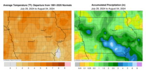
Several rounds of strong to severe thunderstorms early in the reporting period gave way to a warmer and less active pattern by the end of the week. Above-average rainfall was observed in south-central and southeastern Iowa. Temperatures were unseasonably warm with the statewide average temperature at 76.8 degrees, 3.6 degrees above normal.
Sunday (28th) afternoon temperatures quickly rose into the upper 80s and low 90s across southern Iowa as showers and thunderstorms pushed into the state’s northwest corner. The thunderstorm complex moved into central Iowa after sunset and increased in coverage across southern and eastern Iowa through early Monday (29th) morning. Many of the storms were sluggish with moderate to heavy rainfall over swaths of central and southeastern Iowa; 15 stations collected at least 2.00 inches with 3.05 inches in Fairfield (Jefferson County) to 3.51 inches in Indianola (Warren County). Most stations receiving rainfall observed at least 0.50 inch with a statewide average of 0.81 inch. Winds became variable through the day with afternoon temperatures ranging from the mid 80s north to low 90s south under mostly sunny skies. Thunderstorms entered northwestern Iowa just after midnight on Tuesday (30th) and sped southeast. As this severe-warned complex exited southeastern Iowa mid-morning, a secondary squall line followed a nearly identical path, becoming severe-warned in west-central Iowa. Locally heavy rain and several reports of strong wind gusts were reported in central to southeastern Iowa; additional discrete thunderstorms formed behind the line, producing large hail from Ankeny (Polk County) to Pella (Marion County). Stations along the axis of motion reported heavier totals above 0.75 inch with 1.00 inch in Storm Lake (Buena Vista) to 2.30 inches in Montrose (Lee County). Evening conditions were quiet as clouds cleared with a light southerly wind. Scattered overnight thunderstorms fired across central Iowa and slowly pushed southeast as a narrow line developed behind the initial convection. Storm motion was again slow with ample moisture to produce heavy rainfall; flash flood warnings were issued across several southern counties. Rainfall amounts at 7:00 am on Wednesday (31st) were high around Pella, where 5.86 inches was reported. Stations farther southeast including Oskaloosa (Mahaska County) and Ottumwa (Wapello County) registered 2.97 and 2.43-inch totals, respectively. Afternoon temperatures shot up into the mid to upper 80s as clouds moved out. Instability across southern Iowa fed a fast-moving squall line during the evening hours. The line bowed out as it moved through central Iowa, producing high winds and locally heavy rain. A secondary line pushed through northern Iowa, also producing heavy rain; Lake Mills (Winnebago County) collected 2.25 inches. The remaining days of the week were quieter and warm. Temperatures on Thursday (1st) and Friday (2nd) pushed into the 80s with partly sunny skies. Morning lows on Saturday (3rd) only fell into the mid to upper 60s with some fog observed in central to northwest Iowa. Iowans experienced upper 80s and low 90s through the day with light winds and sunny skies. Southern winds returned overnight with starry skies and Sunday (4th) morning lows in the mid to upper 60s.
Weekly precipitation totals ranged from 0.06 inch at Spencer Municipal Airport (Clay County) to 7.67 inches in Pella (Marion County). The statewide weekly average precipitation was 1.67 inches while the normal is 0.95 inch. Several stations reported the week’s high temperature of 96 degrees on multiple days, on average 11 degrees above normal. Algona (Kossuth County) reported the week’s low temperature of 51 degrees on the 2nd, 10 degrees below normal.


(contributed press release, IDALS)


