DES MOINES, Iowa—Iowa Secretary of Agriculture Mike Naig commented on the Iowa Crop Progress and Condition Report released by the USDA National Agricultural Statistics Service. The report is released weekly April through November. Additionally, the Iowa Department of Agriculture and Land Stewardship provides a weather summary each week during this time.
“Iowans flocked to Des Moines during the first few days of the Iowa State Fair, setting an all-time single-day attendance record on Saturday thanks to beautiful weather,” said Secretary Naig. “With favorable growing conditions expected to continue, USDA’s latest projections show record-breaking corn and soybean yield potential, all of which underscores the need to further develop new and existing markets for Iowa commodities.”
The weekly report is also available on the USDA’s website at nass.usda.gov.
Crop Report
Most of the State experienced dry conditions and cool temperatures which allowed Iowa farmers 6.4 days suitable for fieldwork during the week ending August 11, 2024, according to the USDA, National Agricultural Statistics Service. Field activities included harvesting oats for grain, cutting and baling hay, and preparing for the fall harvest.
Topsoil moisture condition rated 3 percent very short, 20 percent short, 72 percent adequate and 5 percent surplus. Subsoil moisture condition rated 3 percent very short, 16 percent short, 77 percent adequate and 4 percent surplus.
Corn silking reached 96 percent this week. Sixty-nine percent of the corn crop has reached dough stage or beyond, 1 day behind last year but 2 days ahead of the five-year average. Seventeen percent of the corn crop has reached the dent stage, 4 days behind last year but 3 days ahead of the average. Corn condition was rated 77 percent good to excellent. Ninety-four percent of soybeans were blooming, equal to the five-year average. Soybeans setting pods reached 74 percent, 5 days behind last year and 2 days behind the average. Soybean condition rated 77 percent good to excellent. Ninety-three percent of oats have been harvested, 1 day ahead of last year and 4 days ahead of average.
The State’s second cutting of alfalfa hay reached 97 percent complete. The State’s third cutting of alfalfa hay reached 45 percent, 1 week behind last year but 2 days ahead of the five-year average. Hay condition rated 75 percent good to excellent. Pasture condition rated 63 percent good to excellent.
Weather Summary
Provided by Justin Glisan, Ph.D., State Climatologist, Iowa Department of Agriculture and Land Stewardship
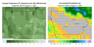
A stable weather pattern dominated Iowa for most of the reporting period with unseasonably cool temperatures to start the Iowa State Fair. Weekly temperature departures were in the negative three to six-degree range with a statewide average temperature of 67.0 degrees, 4.9 degrees below normal. Rainfall was limited to northern and southwestern Iowa with dry conditions in between.
Sunday (4th) afternoon was unseasonably hot with highs in the mid to upper 90s across southern Iowa while upper 80s and low 90s were observed east. Only northwestern Iowa experienced cooler conditions as a weak cold front moved southeast. Isolated thunderstorms from earlier in the day dissipated, though showers reformed across northern Iowa overnight into Monday (5th). Only a handful of stations had measurable totals ranging from 0.01 inch in Mason City (Cerro Gordo County) to 0.51 inch at Grafton (Worth County). Morning temperatures held in the 70s and rebounded into the 90s through the day as a low pressure system skirted the Iowa-Minnesota border. Cloudy conditions developed over the evening hours as showers and a few thunderstorms moved through northeastern Iowa. Gusty northwesterly winds built in as the low’s attendant cold front swept west to east, dropping Tuesday (6th) morning lows into the upper 50s to mid 60s. Rainfall was observed from north-central to northeastern Iowa with eight stations registering an inch or more; Waucoma (Fayette County) had 1.00 inch while 1.89 inches was observed in Lansing (Allamakee County). Amounts tapered off southwest with general totals under 0.20 inch. Clouds gradually cleared northwest to southeast with afternoon temperatures in the upper 60s and low 70s. Variable winds developed into Wednesday (7th) with generally clear skies and lows in the mid 50s northwest to low 60s southeast. Daytime conditions were partly cloudy as highs gradually rose into upper 70s and low 80s with high pressure in control of the Upper Midwest.
Another weak cold front dropped through the state into early Thursday (8th) with light rain showers in southwestern Iowa. Several stations reported varying amounts from 0.01 inch in Atlantic (Cass County) to 0.35 inch in Pacific (Mills County). Isolated showers also developed mid-morning in central Iowa with lighter amounts just west of the Iowa State Fairgrounds; a gauge in Urbandale (Polk County) recorded 0.03 inch from a cell that quickly diminished. Early fairgoers experienced a daytime high of 77 degrees with light northwesterly winds under sunny skies. Friday (9th) morning dawned clear with temperatures in the low 50s and some upper 40s in northwest Iowa. Upper 60s and low 70s greeted Iowans through the day as clouds increased across the state under periodic gusty northwest winds. Westerlies developed into Saturday (10th) with overnight low temperatures in the low 40s over northwestern Iowa to low 50s farther southeast; the statewide average low was 49 degrees, 13 degrees below normal. Afternoon temperatures warmed through the low to mid 70s while spotty clouds moved overhead. Stars were visible into Sunday (10th) morning with lows dropping to the upper 40s in north-central Iowa, while holding in the 50s across the rest of Iowa.
Weekly precipitation totals ranged from no accumulation for most Iowa stations to 1.95 inches in Lansing (Allamakee County). The statewide weekly average precipitation was 0.11 inch while the normal is 0.96 inch. Lamoni (Decatur County) reported the week’s high temperature of 99 degrees on the 4th, 12 degrees above normal. Mapleton (Monona County) reported the week’s low temperature of 43 degrees on the 10th, 18 degrees below normal.


(contributed press release, IDALS)


