DES MOINES, Iowa—Iowa Secretary of Agriculture Mike Naig commented on the Iowa Crop Progress and Condition Report released by the USDA National Agricultural Statistics Service. The report is released weekly April through November. Additionally, the Iowa Department of Agriculture and Land Stewardship provides a weather summary each week during this time.
“With the Farm Progress Show kicking off in central Iowa, much of the state will receive a blast of heat followed by cooler weather as we head into September,” said Secretary Naig. “This stretch of unseasonably dry conditions is providing a nice window for farmers to bale hay, chop silage and begin to seed cover crops.”
The weekly report is also available on the USDA’s website at nass.usda.gov.
Crop Report
The State experienced mostly dry weather this week. These conditions allowed Iowa farmers 6.4 days suitable for fieldwork during the week ending August 25, 2024, according to the USDA, National Agricultural Statistics Service. Primary field activities continued to be cutting and baling hay and preparing for the fall harvest.
Topsoil moisture condition rated 3 percent very short, 23 percent short, 72 percent adequate and 2 percent surplus. Subsoil moisture condition rated 3 percent very short, 20 percent short, 75 percent adequate and 2 percent surplus.
Corn in the dough stage or beyond reached 90 percent this week, 6 days behind last year but 1 day ahead of the five-year average. Forty-five percent of the corn crop reached the dent stage or beyond, 3 days behind last year. Corn mature reached 4 percent. Corn condition rated 77 percent good to excellent. Soybeans setting pods reached 90 percent, 9 days behind last year and 3 days behind the five-year average. Soybeans coloring reached 5 percent, 4 days behind last year and 2 days behind the average. Soybean condition was 77 percent good to excellent.
The State’s third cutting of alfalfa hay reached 79 percent, 6 days behind last year but 6 days ahead of the five-year average. Hay condition rated 77 percent good to excellent. Pasture condition rated 65 percent good to excellent. As temperatures rose at the end of the week, stress became a concern for livestock.
Weather Summary
Provided by Justin Glisan, Ph.D., State Climatologist, Iowa Department of Agriculture and Land Stewardship
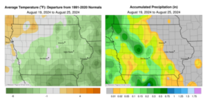
Rainfall was observed across Iowa’s western two-thirds early in the reporting period, though totals were 0.40 to 0.80 inch below normal; in eastern Iowa, deficits were over an inch in certain locations. Temperatures varied from slightly warmer across the northwest to four degrees below normal southeast; the statewide average temperature was 68.4 degrees, 3.2 degrees below normal.
Partly cloudy skies developed over eastern Iowa through Sunday (18th) afternoon with light northerly winds and temperatures in the upper 70s and low 80s. Foggy conditions were observed overnight into Monday (19th) in the absence of strong winds and aided by clear skies for radiational cooling. The smell of Canadian wildfire smoke was also reported across the Upper Midwest from particulate mixing down into the lower atmospheric boundary layer. Northerly winds increased through the day with mid to upper 70s in eastern Iowa and low 80s farther west under sunny skies. Winds became variable after midnight as light rain showers moved along the Iowa-Nebraska border. Showers expanded over northern and central Iowa through much of Tuesday (20th) as daytime temperatures held in the 70s. Event rain totals were generally in the 0.10- to 0.25-inch range for most stations receiving rain. Pockets of southeast, central and northwest Iowa reported totals of more than 0.50 inch; Orange City (Sioux County) registered 0.51 inch while several stations in Lyon County had the highest totals, including a 0.71-inch reading at Larchwood. Mostly cloudy conditions persisted into Wednesday (21st) morning with temperatures in the upper 50s east to mid 60s west. Afternoon conditions remained partly cloudy in western Iowa while clearing occurred in eastern Iowa; afternoon temperatures remained in the low to mid 70s with southeasterly winds. A high pressure center dominating the Upper Midwest pushed farther east overnight with scattered clouds pushing into western Iowa. Thursday (22nd) morning temperatures ranged from the low 50s in eastern Iowa to low 60s west as winds shifted southerly; several eastern stations reported lows in the mid to upper 40s.
Afternoon conditions were ideal with sunny skies, light southerly winds and highs in the 70s. Overcast skies developed near daybreak on Friday (23rd) over northwest Iowa, where low temperatures stayed in the mid 60s; temperatures were five to 10 degrees cooler in eastern Iowa where clear skies and isolated fog were observed. Daytime temperatures were near-seasonal, in the upper 70s and low 80s, with mostly sunny skies. Cloud cover increased in southwestern Iowa through the nighttime hours with isolated thundershowers in west-central Iowa near sunrise on Saturday (24th). A handful of stations received measurable totals with 0.03 inch at Atlantic Municipal Airport (Cass County) and 0.41 inch in Jefferson (Greene County). Temperatures warmed into the mid to upper 80s across much of Iowa with mixed cloud cover in western and central Iowa. Overnight lows into Sunday (25th) were in the mid 60s to mid 70s with a statewide average low of 67 degrees, eight degrees above normal.
Weekly precipitation totals ranged from no accumulation across eastern Iowa to 0.93 inch at Rock Rapids (Lyon County). The statewide weekly average precipitation was 0.08 inch while the normal is 0.93 inch. Lowden (Cedar County) reported the week’s high temperature of 90 degrees on the 24th, eight degrees above normal. Elkader (Clayton County) reported the week’s low temperature of 44 degrees on the 22nd, 13 degrees below normal.


(contributed press release, IDALS)


