DES MOINES, Iowa—Iowa Secretary of Agriculture Mike Naig commented on the Iowa Crop Progress and Condition Report released by the USDA National Agricultural Statistics Service. The report is released weekly April through November. Additionally, the Iowa Department of Agriculture and Land Stewardship provides a weather summary each week during this time.
“After a long stretch of dry conditions that allowed harvest to proceed without much interruption, measurable rainfall finally arrived last week and stayed through the weekend in much of the state. For Iowa farmers still finishing harvest and other field work, the moisture may temporarily delay progress. However, it will also provide the added benefits of reducing dust, decreasing fire risk and helping to replenish our dry soils, waterways and pastures,” said Secretary Naig. “For the many farmers who have seeded cover crops or are planning to do so, the rain also provided a much needed boost toward getting them established. As we look ahead to the next two weeks, outlooks continue to show better chances of warmer temperatures and more rain.”
The weekly report is also available on the USDA’s website at nass.usda.gov.
Crop Report
Much needed rain across the State meant Iowa farmers had just 4.7 days suitable for fieldwork during the week ending November 3, 2024, according to the USDA’s National Agricultural Statistics Service. Field activities included harvesting corn and soybeans, completing fall tillage, and applying fall fertilizer and manure.
Topsoil moisture condition rated 21 percent very short, 38 percent short, 39 percent adequate and 2 percent surplus. Subsoil moisture condition rated 27 percent very short, 42 percent short, 31 percent adequate and 0 percent surplus.
Harvest of the corn for grain crop reached 92 percent statewide, 6 days ahead of last year and 2 weeks ahead of the five-year average. Moisture content of field corn harvested for grain remained steady at 14 percent.
Livestock producers reported weaning calves and sending some to local sale barns. Many feedlots went from dry and dusty to muddy with the rain received during the week.
Weather Summary
Provided by Justin Glisan, Ph.D., State Climatologist, Iowa Department of Agriculture and Land Stewardship
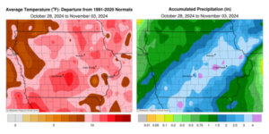
A significant shift in the storm track brought widespread and above-normal rainfall to most of Iowa during the reporting period; nearly a month’s worth of rain fell at many stations. Temperatures remained warmer than average with the highest departures of up to 12 degrees in central Iowa. The statewide average temperature was 53.1 degrees, 7.5 degrees above normal.
Strong southerly winds helped boost Sunday (27th) afternoon temperatures into the mid to upper 60s with ample sunshine. Winds decreased through the evening hours with partly cloudy conditions developing in southwestern Iowa into Monday (28th). Morning lows bottomed out in the 50s with southerly winds persisting. Afternoon temperatures were pleasant, in the 70s, with winds once again becoming gusty and clouds drifting over western Iowa. Temperatures on Tuesday (29th) morning were well-above average across eastern Iowa as a warm front lifted north across the state; upper 60s and low 70s were reported at most stations with upper 40s in the northwest corner and a statewide average low of 53 degrees, 18 degrees above normal. Daytime conditions were exceedingly windy with 45 mph wind gusts reported at municipal airports in Cedar Rapids (Linn County), Davenport (Scott County) and Lamoni (Decatur County). High temperatures were well above average, in the low to mid 80; the statewide average high was 81 degrees, 26 degrees above normal. Cloud cover increased over western Iowa overnight into Wednesday (30th) with a strong Colorado Low pressure center moving into Iowa as thundershowers popped up in eastern Iowa. Stronger thunderstorms, some severe warned, developed in western Iowa over the afternoon and evening hours. Showers and thunderstorms expanded in aerial coverage across much of Iowa through the end of the day and into early Thursday (31st) as the system moved into the Great Lakes. More than 300 National Weather Service and Community Collaborative Rain, Hail and Snow (CoCoRaHS) gauges collected at least 1.00 inch with nearly 100 hitting 2.00 inches; the highest totals were found from south-central to eastern Iowa with 3.00 inches in Dubuque (Dubuque County) and Williamson (Lucas County) to 3.52 inches in Jasper County. The statewide average rainfall was 1.49 inches with a few stations in northwest Iowa reporting measurable snowfall as cold air wrapped in behind the disturbance; Sheldon measured 0.1 inch while 1.7 inches was observed in Sibley (Osceola County).
Overcast skies persisted through Friday (1st) with afternoon highs varying from the upper 30s northeast to low 50s southwest where skies began clearing. Light, variable winds developed into Saturday (2nd) morning with lows in the upper 20s and low 30s statewide under clear skies. A southerly shifting wind allowed temperatures to rise into the mid to upper 50s as clouds increased along the Iowa-Missouri border. Rain showers overspread the state through the nighttime hours and into Sunday (3rd) morning with temperatures holding in the upper 40s and low 50s. Rain totals reported at 7:00 am were highest from central to northeast Iowa with 2.00 inches in Decorah (Winneshiek County) to 2.30 inches in Garwin (Tama County). Nearly 150 stations within the swath as well as northwest and southeast of the highest totals reported at least an inch with a statewide average of 0.80 inch.
Weekly precipitation totals ranged from 0.60 inch in Le Mars (Plymouth County) to 5.05 inches in Vining (Tama County). The weekly statewide average precipitation was 2.29 inches, more than four time the normal of 0.53 inch. Little Sioux (Harrison County) reported the week’s high temperature of 86 degrees on the 29th, 29 degrees above normal. Belle Plaine and Vinton (Benton County) reported the week’s low temperature of 24 degrees on the 1st and 2nd, on average eight degrees below normal.


(contributed press release, IDALS)


