DES MOINES, Iowa—Iowa Secretary of Agriculture Mike Naig commented on the Iowa Crop Progress and Condition Report released by the USDA National Agricultural Statistics Service. The report is released weekly April through November. Additionally, the Iowa Department of Agriculture and Land Stewardship provides a weather summary each week during this time.
“Even as harvest winds down across the state, farmers are still busy completing fall field work as conditions allow,” said Secretary Naig. “Though the rain has temporarily parked some combines and tractors, it has helped green up the cover crops and provided some replenishment for the parched soils and streams. Forecasts through the end of November indicate both seasonal temperatures and precipitation can be expected.”
The weekly report is also available on the USDA’s website at nass.usda.gov.
Crop Report
Iowa’s farmers had an average of 3.6 days suitable for fieldwork during the week ending November 17, 2024, according to the USDA, National Agricultural Statistics Service. Primary fieldwork activities included fall tillage, fertilizer applications, and some row crop harvest. Topsoil moisture condition rated 8 percent very short, 28 percent short, 61 percent adequate and 3 percent surplus. Subsoil moisture condition rated 15 percent very short, 44 percent short, 40 percent adequate and 1 percent surplus. Corn harvested for grain reached 97 percent statewide.
Livestock producers continue to deal with muddy feedlots.
Weather Summary
Provided by Justin Glisan, Ph.D., State Climatologist, Iowa Department of Agriculture and Land Stewardship
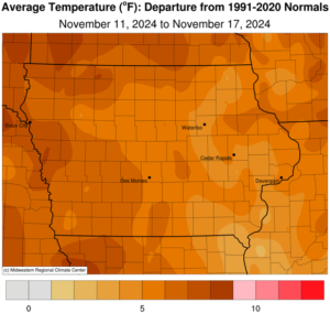
The shift to a wetter weather pattern in early November continued through the reporting period with widespread rainfall statewide and unseasonably wet conditions in western Iowa. Warmer temperatures persisted as well with positive departures nearing eight degrees in western Iowa; the statewide average temperature was 43.1 degrees, 6.4 degrees above normal.
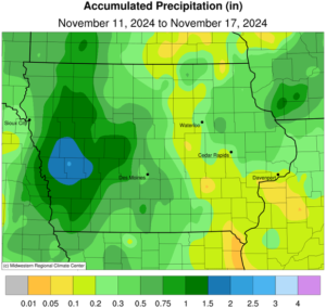
Late morning showers moved out of northeastern Iowa as cloudy skies persisted through Sunday (10th) afternoon. Daytime temperatures held in the low to mid 50s with a westerly wind. Several stations observed rainfall, ranging from 0.13 inch at Harpers Ferry (Allamakee County) to 0.52 inch in Mason City (Cerro Gordo County). Starry skies emerged into Monday (11th) with morning lows in the mid 30s to low 40s north to south with northwesterly winds. Afternoon conditions remained sunny with temperatures in the mid 40s north to low 50s south. Winds shifted easterly and became blustery through Tuesday (12th) as a low pressure system approached Iowa from the southwest. Afternoon temperatures varied from the mid 40s east to upper 50s west with cloud cover increasing across western Iowa. Thundershowers formed ahead of the low pressure center along the Iowa-Nebraska border after midnight on Wednesday (13th). Showers spread across Iowa through the daylight hours as temperatures held in the 40s. The system exited northeastern Iowa late in the night with winds shifting to the northwest as clouds cleared in western Iowa. Event rain totals were highest in western Iowa where 45 stations collected at least 1.00 inch; Atlantic (Cass County) observed 1.52 inches with 1.90 inches in Schleswig (Crawford County). Amounts tapered off to a few tenths farther east with higher readings northeast and a statewide average of 0.47 inch.
Fog was reported across eastern Iowa on Thursday (14th) morning with lows in the mid 40s under cloudy skies. Clearing conditions in western Iowa allowed temperatures to drop into the low to mid 30s. Mostly cloudy skies remained over Iowa’s eastern two-thirds while southerly winds and clear skies were present farther west. Overnight lows into Friday (15th) dropped into the upper 20s and low 30s with very dense fog observed from central to eastern Iowa; some stations reported frozen fog as well. With high pressure dominating the Midwest and a shift to southerly flow, afternoon temperatures rose into the upper 50s to mid 60s under sunshine. Spotty cloud cover developed overnight with southeasterly winds increasing through Saturday (16th) morning and temperatures in the 40s. Showers and a few isolated thunderstorms formed along a weak cold front over the evening hours with rain totals under 0.10 inch; Cedar Falls (Black Hawk County) reported the highest total of 0.08 inch. Colder air filtered in behind the front with northwesterly winds and Sunday (17th) morning temperatures in the mid 30s to mid 40s.
Weekly precipitation totals ranged from 0.02 inch in Decorah (Winneshiek County) to 2.16 inches in Earling (Shelby County). The weekly statewide average precipitation was 0.55 inch; the normal is 0.49 inch. Clarinda (Page County) reported the week’s high temperature of 67 degrees on the 15th, 17 degrees above normal. Elkader (Clayton County) reported the week’s low temperature of 21 degrees on the 12th, five degrees below normal.


(contributed press release, IDALS)


