DES MOINES, Iowa—Iowa Secretary of Agriculture Mike Naig commented on the Iowa Crop Progress and Condition Report released by the USDA National Agricultural Statistics Service. The report is released weekly April through November. Additionally, the Iowa Department of Agriculture and Land Stewardship provides a weather summary each week during this time.
“We give thanks for yet another bountiful harvest across Iowa, despite many challenges including a wet spring, a dry fall and some challenging severe weather. Record or near record yields and production for both corn and soybeans, combined with commodity prices not keeping up with costs, amplifies the continual need to build and expand markets locally, domestically and internationally,” said Secretary Naig. “As Iowans gather around the table this Thanksgiving, I encourage you to think about the farmers that made that meal possible and the work they do every single day. We have much to be thankful for here in Iowa. We are truly blessed to live in the greatest state in the greatest nation, and to be a part of Iowa agriculture.”
The weekly report is also available on the USDA’s website at nass.usda.gov.
Crop Report
Rain along with snow showers in the North East and North Central parts of Iowa resulted in an average of 4.3 days suitable for fieldwork during the week ending November 24, 2024, according to the USDA, National Agricultural Statistics Service. Field activities slowed down this week with reports of fall tillage, and fertilizer and manure applications wrapping up.
Topsoil moisture condition rated 8 percent very short, 26 percent short, 64 percent adequate and 2 percent surplus. Subsoil moisture condition rated 14 percent very short, 41 percent short, 44 percent adequate and 1 percent surplus.
Corn harvested for grain is virtually complete.
Weather Summary
Provided by Justin Glisan, Ph.D., State Climatologist, Iowa Department of Agriculture and Land Stewardship
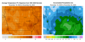
The final reporting period of the year was unseasonably warm and wet with above average rainfall over the western and northern portions of the state; stations in the northwest corner registered positive departures of over an inch. Conditions were up to 10 degrees above average in southeastern Iowa with a statewide average temperature of 39.1 degrees, 4.8 degrees above normal.
Scattered showers continued through southern Iowa into Sunday (17th) afternoon in advance of a large surface low pressure system moving out of Oklahoma. Daytime temperatures held in the low 50s with stations that were experiencing rain reporting totals under 0.10 inch. Clouds increased over southern Iowa into Monday (18th) morning as showers expanded across the state ahead of a warm front. Moderate rainfall was observed over much of western and northern Iowa as the low pressure center propagated north along the Iowa-Nebraska border into Minnesota. High temperatures continued to warm through the evening hours, ranging from the low 50s north to mid 60s south. Gusty westerly winds developed in the wake of the low as clouds cleared from southwest to northeast by sunrise on Tuesday (19th). Nearly 80 stations collected at least an inch of rain with most stations receiving 0.50 inch or more. Western Iowa experienced the wettest conditions with Atlantic (Cass County) and Estherville (Emmet County) each reporting 1.78 inches while Glenwood (Mills County) registered 2.02 inches; the statewide average rainfall was 0.69 inch. Gusty westerlies persisted through the day with overcast skies across northern Iowa and temperatures in the mid to upper 40s. Sunshine over southwestern Iowa boosted temperatures in the 50s as winds died down. A fast-moving cold front dipped through the Upper Midwest during the daylight hours on Wednesday (20th) bringing the first, but very light, snowfall over northeastern Iowa. High temperatures hovered in the low 30s over northern Iowa as snowflakes flew while southern Iowa was 10 to 15 degrees warmer. Nearly 50 stations measured at least 0.1 inch of snow with 1.0 inch observed at Bellevue Lock and Dam (Jackson County).
Thursday (21st) morning was overcast with strong northwesterly winds and lows in the upper 20s and low 30s. Cloud cover began to break across western Iowa into the afternoon with temperatures across the state in the upper 30s and low 40s. Overcast skies in Iowa’s eastern two-thirds continued into Friday (22nd) as morning lows dropped into the upper teens and low 20s in western Iowa where stars were visible. Daytime temperatures rose into the mid to upper 30s in eastern Iowa with low to mid 40s west. Clearing skies and light, variable winds helped morning lows on Saturday (23rd) drop down to the 20s at most of Iowa’s stations with patchy fog observed in eastern Iowa. A shift to southeasterly winds through the day aided temperatures warming through the low 50s in western Iowa with slightly cooler conditions at eastern stations. Winds shifted back to an easterly direction by 7:00 am on Sunday (24th) as clear skies held on and morning temperatures remained in the 30s statewide.
Weekly precipitation totals ranged from 0.20 inch in Fairfield (Jefferson County) to 2.25 inches in Holstein (Ida County). The weekly statewide average precipitation was 0.84 inch; the normal is 0.43 inch. Numerous stations reported the week’s high temperature of 64 degrees on the 18th, on average 16 degrees above normal. Mapleton (Monona County) reported the week’s low temperature of 18 degrees on the 24th, three degrees below normal.


(contributed press release, IDALS)


