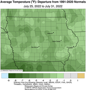
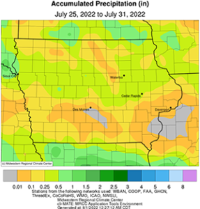
DES MOINES, Iowa—Iowa Secretary of Agriculture Mike Naig commented today on the Iowa Crop Progress and Condition Report released by the USDA National Agricultural Statistics Service. The report is released weekly April through November.“With a warm and dry July in the rearview mirror, Iowa is expected to experience some of the hottest days of summer this week,” said Secretary Naig. “A lack of rainfall across much of the state has led to an expansion of drought conditions with short-term outlooks indicating continued warmth and isolated chances of thunderstorms.”The weekly report is also available on the USDA’s website at nass.usda.gov.Crop ReportVery little precipitation across the State resulted in 6.3 days suitable for fieldwork during the week ending July 31, 2022, according to the USDA National Agricultural Statistics Service. Increasingly dry conditions are a concern for many. Fieldwork included cutting and baling hay and pesticide applications.Topsoil moisture condition rated 17 percent very short, 32 percent short, 50 percent adequate and 1 percent surplus. Subsoil moisture condition rated 15 percent very short, 31 percent short, 53 percent adequate and 1 percent surplus.Corn silking or beyond was 87 percent, 2 days behind both last year and the 5-year average. Thirty percent of the corn crop has reached the dough stage or beyond, 3 days behind last year but even with the average. One percent of Iowa’s corn crop has reached the dent stage, 6 days behind last year and 3 days behind the average. Corn condition fell slightly to 76 percent good to excellent. Eighty-three percent of soybeans were blooming, 1 week behind last year and 2 days behind average. Fifty-two percent of the soybean crop was setting pods, 6 days behind last year and 1 day behind the 5-year average. Iowa’s soybean condition declined slightly to 73 percent good to excellent. Ninety-one percent of oats were turning color or beyond, 8 days behind last year. Oats harvested for grain reached 64 percent, 1 day behind last year and the average.Eighty-nine percent of the State’s second cutting of alfalfa hay was complete, with the third cutting at 13 percent. All hay condition rated 61 percent good to excellent. Pasture condition rated 47 percent good to excellent. Lack of rain stressed pastures and livestock last week.Weather SummaryProvided by Justin Glisan, Ph.D., State Climatologist, Iowa Department of Agriculture and Land StewardshipTemperatures moderated over the final week of July with a statewide average temperature of 69.8 degrees, 3.2 degrees below normal. Unseasonably dry conditions persisted across Iowa as drought intensified in the state’s northwest corner. Rainfall deficits of over an inch were reported in south-central Iowa while near-normal conditions were observed in pockets of western Iowa.A cold front exited southeastern Iowa by early Sunday (24th) afternoon with light north-northwesterly winds and mostly sunny skies. Daytime highs ranged from the upper 70s north to low to mid 80s south as a variable wind built in through the evening hours. Overnight lows into Monday (25th) dropped into the upper 50s and low 60s with increasing clouds across southwest Iowa. Rain showers pushed through much of western Iowa over the afternoon hours with heavier showers moving along the Iowa-Missouri border. High temperatures remained in the 70s across much of Iowa with slightly cooler conditions northwest. Rainfall amounts were generally under a tenth of an inch. Another round of showers and thunderstorms popped up in western Iowa on Tuesday (26th) afternoon with an additional line moving through northeastern Iowa overnight into Wednesday (27th). Sioux City (Woodbury County) measured 0.29 inch while several stations in Winneshiek County reported 0.48 inch to 0.70 inch. Mid to upper 80s were reported statewide as a westerly wind built in. Widespread rain fell over Iowa’s northern half later in the evening and after midnight with general totals in the 0.25-0.50 inch range; Churdan (Greene County) picked up 0.87 inch. Overnight lows into Thursday (28th) dipped into the mid 50s north to low 60s south as cloud cover persisted.A cold front moved through Iowa shifting winds to a northwesterly direction through the day with highs in the mid to upper 70s at most stations as clouds cleared into the early morning hours of Friday (29th). Partly cloudy skies returned later in the day with pleasant temperatures in the upper 70s and low 80s, slightly cooler for this time of the year. Foggy conditions developed in southwestern Iowa as winds died down and skies cleared. Morning lows dipped into the mid to upper 50s prior to sunrise on Saturday (30th). Southerly winds returned as daytime temperatures hovered in the low to mid 80s. Clouds revisited central Iowa through the overnight hours and expanded into southern Iowa on Sunday (31st) morning. Low temperatures dropped into the upper 50s and low 60s under light southerly winds.Weekly precipitation totals ranged from no accumulation at several southern stations to 0.89 inch near Churdan. The statewide weekly average precipitation was 0.24 inch while the normal is 0.94 inch. Oskaloosa (Mahaska County) reported the week’s high temperature of 97 degrees on the 24th, 11 degrees above normal. Storm Lake (Buena Vista County) reported the week’s low temperature of 42 degrees on the 29th, 17 degrees below normal.


