DES MOINES, Iowa—Iowa Secretary of Agriculture Mike Naig commented Monday on the Iowa Crop Progress and Condition Report released by the USDA National Agricultural Statistics Service. The report is released weekly April through November.
“After a warm and dry week, a shift in the weather pattern brought cooler temperatures and widespread rainfall across Iowa over the weekend,” said Iowa Secretary of Agriculture Mike Naig. “Harvest preparations are in full swing with early harvest activities beginning across portions of the state where drier conditions have been more prevalent. While there’s been a chilly start over the last few days, outlooks show unseasonably warm temperatures will return through the middle of September.”
The weekly report is also available on the USDA’s website at nass.usda.gov.
Crop Report
Average rainfall statewide still left Iowa farmers with 6.0 days suitable for fieldwork during the week ending September 11, 2022, according to the USDA, National Agricultural Statistics Service. Fieldwork included chopping corn, harvesting corn for seed, cutting hay, and seeding cover crops. Producers were also preparing equipment for harvest.
Topsoil moisture condition rated 16 percent very short, 29 percent short, 54 percent adequate and 1 percent surplus. Subsoil moisture condition rated 19 percent very short, 32 percent short, 48 percent adequate and 1 percent surplus.
Corn in the dough stage or beyond was 98 percent, 2 days ahead of the 5-year average. Eighty-four percent of Iowa’s corn crop has reached the dent stage or beyond, 1 day behind last year. Twenty-three percent of the State’s corn crop was mature, 2 days behind last year and 1 day behind the 5-year average. Corn condition fell 3 percentage points to 63 percent good to excellent. With virtually all soybeans setting pods, 48 percent have reached coloring or beyond, 4 days behind last year and 2 days behind the 5-year average. Soybeans dropping leaves were at 9 percent, 1 week behind last year and 5 days behind the average. Soybean condition dropped 3 percentage points to 63 percent good to excellent.
Eighty-seven percent of the State’s third cutting of alfalfa hay was complete. Pasture condition remained 32 percent good to excellent. Some producers were feeding cattle high moisture corn and hay.
Weather Summary
Provided by Justin Glisan, Ph.D., State Climatologist, Iowa Department of Agriculture and Land Stewardship
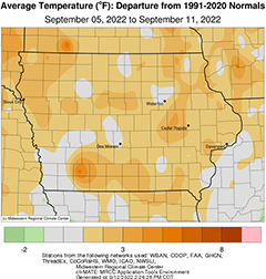
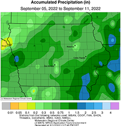
Warmer weather was present for much of the reporting period with temperatures from one to three degrees above normal across much of Iowa; the statewide average temperature was 67.8 degrees, 1.2 degrees above normal. A cold frontal passage over the weekend brought widespread and seasonal rains to Iowa’s reporting stations with above-average totals in southeastern Iowa.
Overcast conditions gradually diminished into Sunday (4th) afternoon with temperatures holding in the 70s as winds blew from an easterly direction. Clouds built back in overnight into Monday (5th) with foggy conditions reported in central and western Iowa. Morning lows ranged from the mid 50s west to mid 60s east with winds becoming variable into early afternoon. High temperatures again settled in the mid 70s with some low 80s observed in northwestern Iowa. Dense fog was again pervasive on Tuesday (6th) morning before burning off as the sun rose with winds shifting to a southeasterly direction. Western Iowa was around 10 degrees warmer than eastern Iowa, where temperatures held in the upper 70s. A high pressure center continued to dominate the weather pattern, lending to pockets of cloud cover and fog into the early hours of Wednesday (7th). Winds were generally calm with upper 50s and low 60s statewide. Mostly sunny skies developed through the afternoon as temperatures pushed into the mid to upper 80s. Southerly winds picked up through the late night hours into Thursday (8th) with morning lows ranging from the mid 50s southeast to mid 60s northwest. Daytime highs were the warmest of the week with several 90-degree readings in western Iowa; the statewide average high was 84 degrees, seven degrees warmer than normal.
Clouds increased across northwestern Iowa through Friday (9th) as a low pressure system approached from the west. High temperatures behind the low’s attendant cold front remained in the mid 60s as light rain showers developed; the rest of Iowa experienced sunny skies and highs in the mid to upper 80s. Thick stratus clouds obscured the sky for the northwestern two thirds of the state, though southeastern Iowa was able to peer at the full Harvest Moon. Moderate rainfall filled in west to east through Saturday (10th) as the cold front swept across Iowa, leaving behind widespread and beneficial totals. A few embedded thundershowers also produced locally heavy downpours. Conditions were dreary and cool through the afternoon with mid 50s in central Iowa sandwiched between more seasonal temperatures west and east. Clouds cleared over western Iowa as colder air filtered in behind the front. Morning lows dipped into the low 40s in western Iowa while holding in the upper 50s in the east where the front was still moving through. Rainfall totals at 7:00 am on Sunday (11th) showed that nearly 40 stations measuring at least an inch with most stations reporting at least 0.20 inch; pockets of heavier totals were found in the northwest and southeast corner with Augusta (Lee County) dumping out 1.50 inches while Little Sioux (Harrison County) observed 2.05 inches.
Weekly precipitation totals ranged from 0.18 inch at Spirit Lake (Dickinson County) to 1.72 inches at Davenport Municipal Airport (Scott County). The statewide weekly average rainfall was 0.85 inch while the normal is 0.83 inch. Sioux City Air National Guard Base (Woodbury County) reported the week’s high temperature of 92 degrees on the 8th, 13 degrees above normal. Sioux City Airport (Woodbury County) reported the week’s low temperature of 40 degrees on the 11th, 13 degrees below normal.


(contributed press release, IDALS)

