DES MOINES, Iowa—Iowa Secretary of Agriculture Mike Naig commented today on the Iowa Crop Progress and Condition Report released by the USDA National Agricultural Statistics Service. The report is released weekly April through November. Additionally, the Iowa Department of Agriculture and Land Stewardship provides a weather summary each week during this time.
“April 10 marks the earliest date to plant corn and remain eligible for federal crop insurance. That means we should begin seeing planters in fields this week,” said Secretary Naig. “Farmers can take advantage of the quieter weather pattern, unseasonably warm conditions and increasing soil temperatures to jumpstart their spring field work.”
The weekly report is also available on the USDA’s website at nass.usda.gov.
Crop Report
Dry conditions and warming temperatures helped Iowa farmers by increasing the days suitable for fieldwork to 3.5 during the week ending April 9, 2023, according to the USDA, National Agricultural Statistics Service. A storm cell brought strong winds and hail to parts of Iowa. Field activities included fertilizer applications and oat seeding.
Topsoil moisture condition rated 3 percent very short, 19 percent short, 73 percent adequate and 5 percent surplus. Subsoil moisture condition rated 7 percent very short, 27 percent short, 62 percent adequate and 4 percent surplus.
Thirteen percent of the expected oat crop has been planted, 1 day ahead of last year but 1 day behind the 5-year average. There were limited reports of oats beginning to emerge.
Pastures were starting to turn green although growth was still minimal. Calving continued. Overall, livestock conditions improved with warmer weather.
Weather Summary
Provided by Justin Glisan, Ph.D., State Climatologist, Iowa Department of Agriculture and Land Stewardship
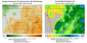
April’s first full week was once again active as another widespread severe weather outbreak occurred across Iowa and several other states. Pockets of large hail and heavy downpours brought moisture across Iowa’s southeastern half, though much of the state experienced drier-than-average conditions. Statewide temperatures varied from four degrees above normal southeast to three degrees below normal northwest; the statewide average temperature was 46.2 degrees, 2.1 degrees above normal.
A cold front swept through Iowa on Sunday (2nd) afternoon shifting winds to a north-northwesterly direction. High temperatures in front of the boundary reached into the upper 60s and low 70s, while 50s prevailed in northwest Iowa. Scattered clouds filtered in across northern Iowa overnight into Monday (3rd) with spotty pockets of light rain. Blustery northwesterly winds produced a cool day under overcast skies with temperatures in the upper 40s northwest to mid 60s southeast. Winds turned to the east in advance of a powerful low-pressure center that was moving towards sout6hwest Iowa on Tuesday (4th). A deck of stratus clouds held temperatures in the upper 30s north to mid 40s south as a warm front lifted into southern Iowa along with anomalous moisture. Severe thunderstorms formed later in the afternoon as clearing skies allowed for atmospheric destabilization in the presence of high temperatures 20 degrees above normal. While this system was a mirror image of the March 31st event, the dominant severe weather mode was very large hail; observers in Osceola (Clarke County) measured 3.50-inch hail that caused structural damage. A swath of 1.00 to 3.00-inch hail was reported across east-central Iowa as initial discrete supercells consolidated into a squall line. A brief tornado was also observed crossing over the Warren County line into Pleasantville (Marion County).
Wednesday (5th) was a windy and cold day statewide as a chilly airmass pushed into the Midwest under high pressure. Sunny skies prevailed with daytime highs in the mid 30s north to mid 40s south. Overnight skies were full of stars with variable winds dying down by sunrise on Thursday (6th) with the statewide average low of 22 degrees, 11 degrees below normal. Afternoon conditions rebounded into the 50s under cloudless conditions. Hazy skies greeted Iowans on Friday (7th) as southerly winds boosted highs into the mid 60s with very low relative humidity, creating ideal conditions for field fires in western Iowa. Saturday (8th) morning conditions held in the upper 30s and low 40s with some scattered clouds in southwestern Iowa. Pleasant temperatures continued throughout the afternoon with highs in the upper 60s and low 70s with a continuing southerly wind. Under generally clear skies, Sunday (9th) morning temperatures mirrored those of the previous day, averaging five degrees above normal.
Weekly precipitation totals ranged from no accumulation at western Iowa stations to 1.45 inches in Clinton (Clinton County). The statewide weekly average precipitation was 0.26 inch while the normal is 0.62 inch. Lamoni (Decatur County) and Shenandoah (Page County) reported the week’s high temperature of 88 degrees on the 4th, on average 28 degrees above normal. Atlantic (Cass County) and Audubon (Audubon County) reported the week’s low temperature of 13 degrees on the 6th, on average 19 degrees below normal. Four-inch soil temperatures were in the mid to upper 40s east to low 50s west as of Sunday.


(contributed press release)


