DES MOINES, Iowa—Iowa Secretary of Agriculture Mike Naig commented today on the Iowa Crop Progress and Condition Report released by the USDA National Agricultural Statistics Service. The report is released weekly April through November. Additionally, the Iowa Department of Agriculture and Land Stewardship provides a weather summary each week during this time.
“Sandwiched between severe storms and chilly snow flurries were some unseasonably warm and dry conditions that allowed farmers to get planters rolling across the state,” said Secretary Naig. “With cooler than average temperatures expected through the end of April, farmers should monitor soil temperatures and be aware of the potential for localized patches of frost.”
The weekly report is also available on the USDA’s website at nass.usda.gov.
Crop Report
Strong winds and warmer than normal temperatures led to drier soil conditions which allowed 5.2 days suitable for fieldwork during the week ending April 16, 2023, according to the USDA, National Agricultural Statistics Service. There were a few isolated areas in the southern part of Iowa that saw more precipitation than average for this time of year. Fertilizer applications continued and oat seeding accelerated. Farmers began planting corn and soybeans although many operators were waiting for precipitation to improve soil moisture supplies.
Topsoil moisture condition rated 7 percent very short, 23 percent short, 66 percent adequate and 4 percent surplus. Subsoil moisture condition rated 9 percent very short, 28 percent short, 60 percent adequate and 3 percent surplus.
Seven percent of Iowa’s expected corn crop has been planted, almost 2 weeks ahead of last year and 6 days ahead of the 5-year average. Over one-third of the State’s expected oat crop was planted during the week ending April 16 to reach 51 percent, 10 days ahead of last year and 6 days ahead of normal. Four percent of the oat crop has emerged.
Pastures continue to break dormancy and become green, but little new growth thus far. Calving continues. Overall, livestock conditions continue to be good.
Weather Summary
Provided by Justin Glisan, Ph.D., State Climatologist, Iowa Department of Agriculture and Land Stewardship
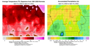
Iowa experienced summerlike conditions over several days of the reporting period as positive temperature departures from 8 to 16 degrees were observed; the statewide average temperature was 58.6 degrees, 11.1 degrees above normal. Coupled with these anomalously warm temperatures, was a very dry airmass until a late-week pattern shift brought widespread rainfall and some snow statewide. Southwestern Iowa measured above-normal totals with deficits of over 0.50 inch at many eastern stations.
Gusty southerly winds continued through Sunday (April 9) afternoon under clear skies with daytime temperatures in the upper 60s and low 70s. A disturbance pushed across western Iowa during the evening hours and persisted through Monday (April 10) morning. Several southwestern and south-central stations measured at least 0.20 inch with Hastings (Mills County) reporting 0.47 inch. Temperatures rose into the low to mid-70s as clouds cleared off through the day under a light and variable wind. Starry skies remained overnight as morning lows reported on Tuesday (April 11) held in the 40s with patchy fog in southwestern Iowa. A strong southerly wind built in over the daylight hours under sunny skies with high temperatures in the upper 70s and low 80s as a dry airmass overtook the Upper Midwest. Morning lows on Wednesday (April 12) were unseasonably warm with a statewide average low of 51 degrees, 16 degrees above normal. Afternoon conditions were exceedingly dry with dewpoint temperatures in the upper 40s in the presence of strong southwesterly winds and air temperatures in the low 80s south to low 90s north; the statewide average high was 83 degrees, 24 degrees above normal. Winds died down overnight as temperatures dropped into the 50s. Southerly winds began to increase through Thursday (April 13) with daytime temperatures generally 10 to 12 degrees cooler than the prior day.
Isolated showers popped up in northwestern Iowa a few hours after sunrise on Friday (April 14). Another line of showers and a few thunderstorms developed in western Iowa after noon with temperatures in the upper 70s and low 80s across much of Iowa. Behind the cold front, conditions cooled into the upper 60s where clouds and rain were present. In advance of a low-pressure system, strong to severe storms formed after sunset over southwestern Iowa, expanding in coverage while losing strength as the cluster pushed into central Iowa. There were several reports of severe straight-line wind events causing structural damage with a 68 mph wind gust clocked near Essex (Page County). The low slowly moved through Iowa on Saturday (April 15) as showers and thunderstorms brought widespread rainfall. Iowa’s eastern quarter remained mostly clear with highs reaching into the mid-70s while upper 30s to mid-40s were observed in western Iowa. Light snow filtered on the backside of the low pressure as rainfall moved into eastern Iowa overnight into Sunday (April 16). All Iowa stations reported measurable precipitation with over 50 measuring at least 0.50 inch; the highest totals were observed in southwest Iowa where eight stations recorded from 1.00 inch to 1.74 inches. Snow totals were isolated with 0.1 inch in Davenport (Scott County) to 3.5 inches in Swea City (Kossuth County).
Weekly precipitation totals ranged from 0.01 inch at multiple stations to 2.21 inches in Hastings. The statewide weekly average precipitation was 0.44 inch while the normal is 0.81 inch. Airports in Sioux City (Woodbury County) and Spencer (Clay County) reported the week’s high temperature of 92 degrees on April 14, on average 33 degrees above normal. Beaconsfield (Ringgold County) reported the week’s low temperature of 27 degrees on April 10, eight degrees below normal. Four-inch soil temperatures were in the low to mid-40s east to upper 40s and low 50s west as of Sunday.


(contributed press release, IDALS)

