DES MOINES, Iowa—Iowa Secretary of Agriculture Mike Naig commented today on the Iowa Crop Progress and Condition Report released by the USDA National Agricultural Statistics Service. The report is released weekly April through November. Additionally, the Iowa Department of Agriculture and Land Stewardship provides a weather summary each week during this time.
“Damp conditions early last week eventually gave way to warmer and drier weather, which allowed many farmers across the state to wrap up planting,” said Secretary Naig. “While the haze from the Canadian wildfires will dissipate by mid-week, forecasts show the warmer and drier conditions will stick around all week.”
The weekly report is also available on the USDA’s website at nass.usda.gov.
Crop Report
Cooler than normal temperatures and relatively dry weather helped Iowa farmers to 4.8 days suitable for fieldwork during the week ending May 21, 2023, according to the USDA, National Agricultural Statistics Service. Farmers were still planting corn, soybeans, and oats this week, although planting activities were nearing completion.
Topsoil moisture condition rated 5 percent very short, 20 percent short, 71 percent adequate and 4 percent surplus.Subsoil moisture condition rated 7 percent very short, 25 percent short, 65 percent adequate and 3 percent surplus.
Ninety-five percent of Iowa’s expected corn crop has been planted, 9 days ahead of last year and 12 days ahead of the 5-year average. Sixty-five percent of the corn crop has emerged, 6 days ahead of last year and 4 days ahead of the average. Eighty-four percent of Iowa’s expected soybean crop has been planted, just over a week ahead of last year and nearly 2 weeks ahead of normal. Forty-three percent of soybeans have emerged, 8 days ahead of last year and 6 days ahead of average. Ninety-four percent of the expected oat crop has emerged, 8 days ahead of normal.Eleven percent of the oat crop has headed, 9 days ahead of last year and 10 days ahead of the average. Oat condition improved to 80 percent good to excellent.
Eight percent of the State’s first cutting of alfalfa hay has been completed. Hay condition declined to 66 percent good to excellent. Pasture condition rated 58 percent good to excellent. Reports of livestock turned out to pasture were received again this week, overall livestock conditions are good.
Weather Summary
Provided by Justin Glisan, Ph.D., State Climatologist, Iowa Department of Agriculture and Land Stewardship
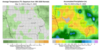
Canadian wildfire smoke was pervasive over Iowa on several days of the reporting period as a less active storm track brought widespread, though below-normal rainfall. Most of Iowa’s weather stations reported deficits of at least an inch with northeast and southwest stations slightly wetter. Temperatures were below normal across portions of western and northern Iowa with near-average conditions over the rest of the state; the statewide average temperature was 60.7 degrees, 2.1 degrees below normal.
Showers with moderate rainfall continued across northeastern Iowa through Sunday (14th) afternoon with temperatures ranging from the low 50s north to the 70s south. Thirteen stations near the state’s eastern border reported over an inch of rain with Elma (Howard County) observing 2.75 inches as totals tailed off rapidly farther west. A low pressure spinning over Missouri brought additional showers to southwestern Iowa through the early morning hours on Monday (15th). Heavier rain was reported in slower moving cells, producing a pocket of 1.50-3.00 inch totals in Decatur County; Lamoni registered 2.75 inches with many southwestern stations that reported rainfall receiving at least 0.50 inch.
Light rain lingered over southern Iowa as sunny skies prevailed in northern Iowa where highs pushed into the upper 60s and low 70s. Winds shifted to the northwest overnight with Tuesday (16th) morning lows hovering in the low 60s statewide as clouds gradually diminished southwest. Daytime highs rose into the upper 70s and low 80s with low humidity and sunny skies. Cloudless conditions and light, variable winds were observed into Wednesday (17th) as Iowans experienced pleasant afternoon conditions. Daytime highs ranged from the mid-60s northeast to the low 80s southwest. Southeasterly winds developed through the nighttime hours in advance of a cold front to the west.
Thursday (18th) morning lows stayed in the 50s as dense Canadian wildfire smoke mixed down into the lower atmosphere across northwestern Iowa. Afternoon highs reached the low to mid-80s at many stations as the cold front moved into central Iowa. Thundershowers formed in the late afternoon as upper-level smoke overspread the skies behind the boundary. Rainfall totals reported at 7:00 am on Friday (19th) were generally under 0.20 inch, though a handful of stations reported higher totals ranging from 0.25 inch at Monticello (Jones County) to 0.52 inch in Randolph (Fremont County).
Morning lows were still in the 60s in southeastern Iowa, while behind the front mid-40s to low 50s were experienced. The rising sun’s color was vivid as the smoky haze remained into the afternoon with daytime highs in the upper 50s north to mid-60s south. Starry skies reigned into Saturday (20th) with chilly mid to upper 30s registering in western Iowa while the 40s blanketed eastern Iowa; the statewide average low was 41 degrees, 10 degrees below normal. Light wind and sunny skies remained through the day as upper 60s and low 70s produced ideal late spring conditions. Pockets of fog were observed into early Sunday (21st) with lows in the 40s to low 50s.
Weekly rain totals ranged from no accumulation at western and northern Iowa stations to 3.04 inches at Lamoni Municipal Airport. The statewide weekly average precipitation was 0.29 inch, while the normal is 0.92 inch. Airports in Ames (Story County) and Waterloo (Black Hawk County) reported the week’s high temperature of 85 degrees on the 18th, on average 12 degrees above normal. Atlantic (Cass County) reported the week’s low temperature of 34 degrees on the 20th, 17 degrees below normal.


(contribute press release, IDALS)


