DES MOINES, Iowa—Iowa Secretary of Agriculture Mike Naig commented on the Iowa Crop Progress and Condition Report released by the USDA National Agricultural Statistics Service. The report is released weekly April through November. Additionally, the Iowa Department of Agriculture and Land Stewardship provides a weather summary each week during this time.
“Overall pleasant weather helped produce record attendance at the Iowa State Fair over the last week and half, even with a few rainy days mixed in,” said Secretary Naig. “That widespread rain, coupled with the warmer temperatures forecasted through the end of August, should give crops a good boost heading into September.”
The weekly report is also available on the USDA’s website at nass.usda.gov.
Crop Report
Iowa farmers averaged 4.8 days suitable for fieldwork during the week ending August 18, 2024, according to the USDA, National Agricultural Statistics Service. Field activities included cutting and baling hay and preparing for the fall harvest.
Topsoil moisture condition rated 2 percent very short, 17 percent short, 77 percent adequate and 4 percent surplus. Subsoil moisture condition rated 3 percent very short, 16 percent short, 77 percent adequate and 4 percent surplus.
Corn in the dough stage or beyond reached 82 percent this week, 3 days behind last year but 2 days ahead of the five-year average. Twenty-eight percent of the corn crop has reached the dent stage, 3 days behind last year but 1 day ahead of the five-year average. The corn crop has just begun to mature. Corn condition was rated at 77 percent good to excellent. Ninety-six percent of soybeans were blooming with 83 percent setting pods, 1 week behind last year and 3 days behind average. Soybeans have just begun turning color. Soybean condition was 77 percent good to excellent. Ninety-six percent of oats have been harvested for grain.
The State’s third cutting of alfalfa hay reached 63 percent, 1 week behind last year but 4 days ahead of the five-year average. Hay condition rated 79 percent good to excellent. Pasture condition rated 72 percent good to excellent.
Weather Summary
Provided by Justin Glisan, Ph.D., State Climatologist, Iowa Department of Agriculture and Land Stewardship
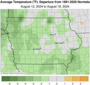
Widespread rainfall was observed through the reporting period with above-normal totals in southern and western Iowa. Overall conditions were generally cool and pleasant for the Iowa State Fair. Temperatures across Iowa varied from near-normal to nearly four degrees below normal in the northwest; the statewide average temperature of 70.0 degrees, 2.2 degrees below normal.
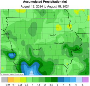
Partly sunny skies persisted across eastern Iowa through Sunday (11th) afternoon as clouds increased farther west. Daytime temperatures held in the 70s and southerly winds developed in advance of the next weather system to impact Iowa. Showers and a few thunderstorms pushed into Iowa overnight and expanded to cover most of the state by daybreak on Monday (12th). Light showers remained in east-central Iowa through the afternoon hours as temperatures varied from the upper 60s west to upper 70s east. Most stations in the southwestern two-thirds of Iowa reported at least 0.25 inches with widespread 0.50-1.00 inch readings across swaths of central and southern Iowa; two stations in Council Bluffs (Pottawattamie County) registered 2.19 and 2.70 inches. Overcast clouds remained over most of the state into Tuesday (13th) morning with upper 50s and low 60s over northern Iowa along with widespread fog; temperatures were five to 10 degrees warmer farther south. Afternoon temperatures rose into the 70s with spotty low-80 degree readings in far eastern Iowa where skies were clear. Winds shifted to an east-southeasterly direction through the early morning hours on Wednesday (14th) as stronger storms with moderate to heavy rainfall moved into southwestern Iowa ahead of an outflow boundary. Rain continued over much of southern Iowa through late morning as a secondary complex of showers propagated over northern Iowa into the afternoon and early evening hours. A warm front associated with a low pressure center over Minnesota lifted over southwestern Iowa and acted as a focusing mechanism for additional storms into the nighttime hours. More widespread development occurred through the early hours of Thursday (15th) with showers finally moving out of eastern Iowa by noon. More than half of Iowa’s stations observed at least 0.80 inch of rainfall with nearly 155 stations hitting one inch or more. Forty stations in eastern and southern Iowa registered at least 2.00 inches; Truro (Madison County) collected 3.00 inches with and additional 3.48 inches in Council Bluffs. The statewide average for the event was 0.97 inch.
A mid-level disturbance behind the exiting system fired isolated storms, some severe warned, across southern Iowa into the evening. Heavier rainfall was reported over counties adjacent to the Mississippi River, from 0.65 inch in Keokuk (Lee County) to 1.47 inches at Bellevue Lock and Dam (Jackson County). Totals into east-central Iowa tapered off to a few tenths. Starry skies were visible at sunrise on Friday (16th) as morning lows dropped into the mid to upper 60s with a westerly wind. Increasing clouds over northern Iowa held high temperatures in the mid to upper 70s while conditions approached the upper 80s in the southwest. Scattered thundershowers developed in northeast Iowa on the backside of the low pressure feature over the Great Lakes. A handful of stations reported measurable totals with 0.21 inch in Osage (Mitchell County) to 0.85 inch in Decorah (Winneshiek County). Widespread cloud cover formed into Saturday (17th) with morning temperatures in the low 60s west to upper 60s east under northwesterly winds. Afternoon conditions were pleasant for much of Iowa with upper mid 70s to low 80s statewide and a few passing showers in eastern Iowa. Patchy fog was observed on Sunday (18th) morning with lows in the mid to upper 50s northwest.
Weekly precipitation totals ranged from 0.38 inch at Oelwein Municipal Airport (Fayette County) to 5.67 inches in Council Bluffs. The statewide weekly average precipitation was 1.33 inches while the normal is 0.93 inch. Several stations reported the week’s high temperature of 89 degrees on the 16th, on average five degrees above normal. Multiple stations reported the week’s low temperature of 48 degrees on the 12th and 18th, on average 12 degrees below normal.
(contributed press release, IDALS)