DES MOINES, Iowa— Iowa Secretary of Agriculture Mike Naig commented on the Iowa Crop Progress and Condition Report released by the USDA National Agricultural Statistics Service. The report is released weekly April through November. Additionally, the Iowa Department of Agriculture and Land Stewardship provides a weather summary each week during this time.
“Iowa’s harvest progress took a big leap forward this week,” said Secretary Naig. “After the driest September on record, the warm and dry weather is expected to continue through mid-October. While this is helpful for harvest, drought conditions are likely to expand throughout the state.”
The weekly report is also available on the USDA’s website at nass.usda.gov.
Crop Report
Iowa experienced another week of dry and windy conditions which allowed farmers 6.7 days suitable for fieldwork during the week ending October 6, 2024, according to the USDA, National Agricultural Statistics Service. Corn and soybean harvest continued to be the primary field activities for the week. Combine and other equipment fires were reported as weather conditions increased the risk of such fires.
Topsoil moisture condition rated 22 percent very short, 42 percent short, 36 percent adequate and 0 percent surplus. Subsoil moisture condition rated 16 percent very short, 44 percent short, 39 percent adequate and 1 percent surplus.
Corn mature reached 90 percent, 6 days behind last year but 5 days ahead of the five-year average. Corn harvested for grain reached 22 percent, 2 days behind last year but 1 day ahead of normal. Moisture content of field corn being harvested for grain was 18 percent. Corn condition rated 77 percent good to excellent. Soybeans dropping leaves reached 93 percent, 1 day ahead of last year and 5 days ahead of the five-year average. Soybeans harvested reached 58 percent this week, 4 days ahead of last year and 1 week ahead of the average. Iowa farmers were able to harvest 31 percent of the State’s soybean crop during the week ending October 6, 2024. Soybean condition rated 76 percent good to excellent.
Pasture condition continued to fall and rated just 38 percent good to excellent this week, a decrease of 6 percentage points. Livestock water resources continue to be a concern.
Weather Summary
Provided by Justin Glisan, Ph.D., State Climatologist, Iowa Department of Agriculture and Land Stewardship
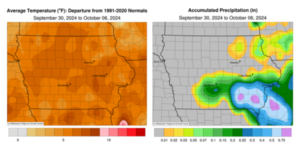
The first week of October experienced continued unseasonably warm conditions as a stable weather pattern dominated the region; the statewide average temperature was 62.9 degrees, 6.5 degrees above normal. This was also the fifth consecutive reporting period of below average rainfall with much of northern and western Iowa in moisture deficits as drought expands.
Sunday (29th) afternoon was pleasant with low dewpoints and temperatures in the low to mid 80s under sunny skies. Morning temperatures on Monday (30th) dropped into the 40s across portions of western Iowa with mid to upper 50s over the rest of Iowa. Gusty southerly winds built in through the daytime hours with some clouds in eastern Iowa and temperatures in the 80s. Temperatures dropped, and winds shifted northwesterly as a cold front pushed though the state into Tuesday (1st) morning. Conditions were in the low to mid 40s in western Iowa while mid to upper 50s were observed ahead of the boundary in eastern Iowa. Afternoon temperatures held in the mid to upper 60s under cloudless skies and light northerly winds. Winds swung to a southerly direction after midnight with morning lows on Wednesday (2nd) ranging from the upper 30s southeast to upper 40s northwest with patchy cloud cover in southwest Iowa. Southwesterly winds became gusty ahead of a cold front crossing through the Upper Midwest; highs were comfortable in the 70s with ample sunshine. Thursday (3rd) started off with lows in the mid 40s east to mid 50s west with winds turning east as a low pressure center approached Iowa from the southwest. Daytime temperatures warmed into the 80s across southern Iowa while low 70s were reported farther north. Clouds increased across the state as the cold front swung southeast. A line of showers and elevated thunderstorms formed just after midnight along and south of I-80. Several storms were severe-warned after quickly intensifying as they moved through southeastern Iowa, producing moderate to heavy rain and pea-sized hail. The highest rain totals ranged from 0.50 inch in Muscatine (Muscatine County) to over 1.00 inch in Ottumwa (Wapello County) and Columbus Junction (Louisa County). Lesser amounts, at or under 0.20 inch, were reported at several central and northeastern Iowa stations. Friday (4th) dawned chilly in northwestern Iowa with upper 30s and low 40s reported. Lingering clouds held temperatures in the mid to upper 50s southeast as the front pushed east. Afternoon conditions were sunny and near seasonal with highs in the low 70s and easterly winds. Partly cloudy skies developed into Saturday (5th) with patchy fog at southwestern stations and low temperatures in the 50s. Daytime temperatures quickly rose into the upper 80s and low 90s across much of Iowa as a cold front swept into western Iowa. Atlantic (Cass County) hit 96 degrees, just one degree off the statewide record high temperature for October set in 1897; the average high was 87 degrees, 19 degrees above normal. Starry skies were visible overnight with morning lows on Sunday dropping into the mid 30s in northeastern Iowa.
Weekly rain totals ranged from no accumulation across much of Iowa to 1.20 inches in Columbus Junction. The statewide weekly average rainfall was 0.10 inch while the normal is 0.74 inch. Atlantic reported the week’s high temperature of 96 degrees on the 5th, 26 degrees above normal. Elkader (Clayton County) and Spencer Municipal Airport (Clay County) reported the week’s low temperature of 34 degrees on the 3rd and 6th, respectively, eight degrees below normal.


(contributed press release, IDALS)


