DES MOINES, Iowa— Iowa Secretary of Agriculture Mike Naig commented on the Iowa Crop Progress and Condition Report released by the USDA National Agricultural Statistics Service. The report is released weekly April through November. Additionally, the Iowa Department of Agriculture and Land Stewardship provides a weather summary each week during this time.
“Warm and dry conditions continued across much of the state last week, providing a window for significant harvest progress. Despite cooler temperatures, mostly dry conditions are expected to persist in the week ahead, allowing harvest activity to steadily roll on. However, outlooks into the second half of October show rainfall potential,” said Secretary Naig. “As harvest continues, I encourage drivers to be on the lookout for farm machinery on the roads at all hours of the day and night. Please slow down and share the road to keep drivers and farmers safe this fall.”
The weekly report is also available on the USDA’s website at nass.usda.gov.
Crop Report
Continued dry weather and above normal temperatures allowed Iowa farmers 6.8 days suitable for fieldwork during the week ending October 13, 2024, according to the USDA, National Agricultural Statistics Service. Field activities included harvesting corn and soybeans, baling corn stalks, applying manure and fertilizers, and fall tillage. Fire danger in fields remains a threat.
Topsoil moisture condition rated 35 percent very short, 41 percent short, 24 percent adequate and 0 percent surplus. Subsoil moisture condition rated 27 percent very short, 45 percent short, 28 percent adequate and 0 percent surplus.
Corn reached 97 percent mature or beyond. Corn harvested for grain reached 45 percent, 3 days ahead of last year and 6 days ahead of the five-year average. Corn moisture content fell 2 percentage points to 16 percent. Corn condition rated 76 percent good to excellent. Soybeans dropping leaves or beyond reached 98 percent. Nearly one-quarter of the soybean crop was harvested during the week ending October 13 reaching 81 percent complete, 6 days ahead of last year and 10 days ahead of the average. Farmers in south central Iowa remain considerably behind farmers in the rest of the State with just 54 percent of their soybean crop harvested.
Pasture condition fell 8 percentage points to just 30 percent good to excellent this week. Livestock water resources continue to recede.
Weather Summary
Provided by Justin Glisan, Ph.D., State Climatologist, Iowa Department of Agriculture and Land Stewardship
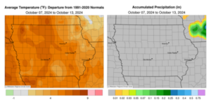
The second reporting period of October was the driest of the year with only a few stations reporting trace amounts of rainfall; October so far is running just under 10% of normal precipitation. Warm conditions also continued with temperatures up to six degrees warmer than normal in western Iowa; the statewide average temperature was 59.6 degrees, 5.4 degrees above normal.
Gusty northwesterly winds built in through Sunday (6th) afternoon with high temperatures ranging from the mid 60s north to low 70s south. Clear skies and calm winds allowed for widespread below freezing temperatures over northern Iowa into the morning hours of Monday (7th); the statewide average low was 36 degrees, seven degrees below normal. Afternoon temperatures rebounded into the mid to upper 60s with wildfire smoke observed across portions of southern Iowa. Tuesday (8th) started off with clear skies with morning lows in the mid 30s to low 40s and patchy fog at southwestern stations. Daytime conditions remained sunny with southwesterly to westerly winds and highs in the mid to upper 70s. Spotty clouds filtered into the state overnight into Wednesday (9th) with variable winds and temperatures in the upper 40s to low 50s south; temperatures farther north held in the upper 30s and low 40s. Upper 70s and low 80s were reported through the daylight hours as cloudless conditions continued into Thursday (10th) morning. Winds shifted to the east with temperatures in the mid to upper 40s at most locations. A southerly shifting wind boosted highs into the mid to upper 80s across Iowa’s western half with mid to upper 70s towards the eastern side the state. With an anomalously strong solar storm impacting Earth, vivid Aurora Borealis were observed through the late evening and nighttime hours. Friday (11th) dawned mostly clear with lows in the 50s for most of Iowa; several readings in the 40s were registered in eastern Iowa. Winds began shifting northerly as a cold front moved southeast across the state. Highs behind the front were in the low to mid 70s while the mid 80s were reported ahead of the front. Very light showers were visible on RADAR along the boundary, however only a trace amount of rainfall was observed at a few eastern Iowa stations, including Decorah (Winneshiek County) and Muscatine (Muscatine County). A weak low pressure center skirted the Iowa-Missouri border overnight and through much of Saturday (12th), shifting easterly winds back to a northerly direction. Daytime conditions remained seasonal over northern Iowa with warmer temperatures across southeastern corner, in the low to mid 80s. Windy conditions returned after sunrise on Sunday (13th) as most stations reported lows in the 40s under clear skies.
Weekly precipitation totals ranged from no accumulation across the vast majority of Iowa to trace amounts at a handful of stations. There was no measurable weekly statewide average precipitation; the normal is 0.60 inch. Osceola (Clarke County) and Shenandoah (Page County) reported the week’s high temperature of 89 degrees on the 11th, 21 degrees above normal. Mapleton (Monona County) reported the week’s low temperature of 28 degrees on the 7th, 13 degrees below normal.


(contributed press release, IDALS)


