DES MOINES, Iowa—Iowa Secretary of Agriculture Mike Naig commented on the Iowa Crop Progress and Condition Report released by the USDA National Agricultural Statistics Service. The report is released weekly April through November. Additionally, the Iowa Department of Agriculture and Land Stewardship provides a weather summary each week during this time.
“Last week brought another round of severe weather. I visited southwest Iowa over the weekend, where I saw firsthand some of the damage caused by the tornadoes and large hail. My heart goes out to all the Iowans who were impacted by these storms,” said Secretary Naig. “Although many farmers got a good start with spring field work, the widespread rain and storms over the holiday weekend could temporarily pause further progress. Forecasts for the coming week show multiple rounds of showers possible across the state. While more delays may occur, the rain will help replenish soil moisture, which would be a welcome development in many areas.”
The weekly report is also available on the USDA’s website at nass.usda.gov.
Crop Report
Planters were rolling across much of the State before being slowed by precipitation. Iowa farmers averaged 5.5 suitable for fieldwork for the week ending April 20, 2025, according to the USDA, National Agricultural Statistics Service. In addition to planting corn, soybeans and oats, fieldwork included tiling, building waterways and spraying when winds allowed.
Topsoil moisture condition rated 6 percent very short, 22 percent short, 69 percent adequate and 3 percent surplus. Subsoil moisture condition rated 7 percent very short, 30 percent short, 61 percent adequate and 2 percent surplus.
Corn planted reached 18 percent, 3 days ahead of last year and 5 days ahead of the 5-year average. Eleven percent of the expected soybean crop has been planted, 3 days ahead of last year and 1 week ahead of the 5-year average. Oats seeding reached 68 percent complete, 5 days behind last year but 3 days ahead of the 5-year average. Twenty-three percent of the expected oat acreage has emerged, 4 days behind last year but 5 days ahead of normal.
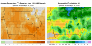
Weather Summary
Provided by Justin Glisan, Ph.D., State Climatologist, Iowa Department of Agriculture and Land Stewardship
An active weather pattern ramped up across Iowa with hail, high winds and a few tornadoes. These thunderstorms brought above-normal rainfall to swaths of northern and southern Iowa, however several stations reported no measurable totals. Temperatures were several degrees warmer across the state with Iowa’s average temperature at 52.6 degrees, 3.2 degrees above normal.
Scattered showers with a few rumbles of thunder pushed across northern Iowa on Sunday (13th) afternoon as daytime temperatures rose into the 70s. Several stations reported at least a trace with 0.11 inch in Osage (Mitchell County) and 0.15 inch in Algona (Kossuth). Winds shifted to the northwest overnight into Monday (14th), becoming blustery as lows held in the mid 40s west to low 50s east. Skies over Iowa were partly to mostly cloudy through the day with temperatures in the mid 50s over northern Iowa and a few degrees warmer farther south. Spotty, light showers moved southeast through the state during the afternoon hours as an upper-level disturbance transited the Upper Midwest. Over 60 stations receiving measurable amounts reported under 0.10 inch except for Lake Park (Dickinson County), which observed 0.12 inch. Gusty northwesterly winds persisted on Tuesday (15th) as clouds cleared in western Iowa at daybreak; morning lows there were in the low 30s while holding in the low 40s in eastern Iowa under cloud cover. Afternoon temperatures warmed into the upper 50s and low 60s with sunshine and patchy haze. Wednesday (16th) started chilly in eastern Iowa where upper 20s and low 30s were observed. Clear skies reigned over the state with an easterly wind signaling a shift to a more active pattern. As a low pressure system approached Iowa, winds swung to a southerly direction, helping boost afternoon highs in the mid to upper 70s in portions of western Iowa; 60s were reported east.
Thursday (17th) was an active weather day across the Midwest with morning temperatures at many stations in the upper 50s and low 60s, 10-20 degrees above normal. The scattered thundershowers that formed before sunrise in central Iowa continued through eastern Iowa before dissipating after noon. Across Iowa’s northern two-thirds, temperatures climbed into the upper 70s and low 80s as dew point temperatures pushed into the upper 50s ahead of ample moisture flow from the Gulf. As a strong low pressure system moved across northern Iowa, the attendant cold front fired the first round of strong to severe thunderstorms. During the evening hours, two supercell thunderstorms formed in eastern Nebraska and moved into southwest Iowa. These cells had a history of producing large hail and tornadoes; McClelland reported 4.00-inch hail with 2.75 inches observed in Essex (Page County). This storm had a long-track, wedge tornado that moved from Tabor (Fremont County) to Essex, where a Tornado Emergency was issued. Another tornado was reported by a trained spotter in Oakland (Pottawattamie County). The storms held together into central and eastern Iowa, though losing a great deal of strength. Farther northwest, severe thunderstorms with strong winds and large hail moved over the length of the state. Reports of hail and some wind damage came in from Sioux City (Woodbury County), Storm Lake (Buena Vista County) and Waverly (Bremer County). Event rain totals reported at 7:00 am on Friday (18th) had nearly 75 stations at or above 0.50 inch with 20 stations collecting an inch or more. The highest totals were southwest and north central with 1.49 inches at Mason City Municipal Airport (Cerro Gordo County) to 2.42 inches in Corning (Adams County), the highest total of the week. Saturday (19th) was pleasant with light winds and highs in the 50s under mostly sunny skies. Overcast conditions developed across southern Iowa into Sunday (21st) morning with temperatures in the upper 30s to mid 40s north to south.
The statewide weekly average precipitation was 0.35 inch while the normal is 0.91 inch. Three northwest stations reported the week’s high temperature of 85 degrees on the 17th, on average 26 degrees above average. Several northern stations reported the week’s low temperature of 25 degrees on the 16th, on average nine degrees below normal. Four-inch soil temperatures were in the upper 40s north to upper 50s south as of Sunday.
(contributed press release, IDALS)