
DES MOINES, Iowa—Iowa Secretary of Agriculture Mike Naig commented on the Iowa Crop Progress and Condition Report released by the USDA National Agricultural Statistics Service. The report is released weekly April through November. Additionally, the Iowa Department of Agriculture and Land Stewardship provides a weather summary each week during this time.
“Widespread rainfall across the state delayed planting last week, but provided much-needed moisture, easing drought conditions across portions of Iowa,” said Secretary Naig. “Outlooks for the next few weeks show unseasonably warm temperatures and perhaps a break in the wet weather, which would give farmers a window to get in the field. Weather models are showing much of Iowa has an elevated risk of experiencing varying types and strength of severe weather this afternoon and evening. This is a good reminder to Iowans to be vigilant, have safety plans in place and be ready to take shelter if needed.”
The weekly report is also available on the USDA’s website at nass.usda.gov.
Crop Report
Periodic rains throughout the week resulted in just 2.3 days suitable for fieldwork during the week ending April 27, 2025, according to the USDA, National Agricultural Statistics Service. While needed, the precipitation slowed or stopped fieldwork and cool temperatures hampered crop emergence.
Topsoil moisture condition rated 3 percent very short, 11 percent short, 75 percent adequate and 11 percent surplus. Subsoil moisture condition rated 4 percent very short, 21 percent short, 67 percent adequate and 8 percent surplus.
Corn planted reached 34 percent, 2 days ahead of the 5-year average. Statewide, corn emerged was 2 percent. Twenty-five percent of the expected soybean crop has been planted, 1 day ahead of last year and 4 days ahead of the 5-year average. Oats seeding reached 81 percent complete, 4 days behind last year but 2 days ahead of the 5-year average. Forty-one percent of the expected oat acreage has emerged, 3 days behind last year but 4 days ahead of normal.
Pastures and grass continue to green up. Apart from some muddy feedlots, no livestock issues were reported. Some cow calf pairs were being turned out to pasture.
Weather Summary
Provided by Justin Glisan, Ph.D., State Climatologist, Iowa Department of Agriculture and Land Stewardship
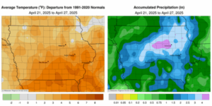
Most of Iowa experienced an unseasonably wet reporting period with the passage of several rounds of showers and thunderstorms. The wettest conditions were reported across central to northeast Iowa with positive departures on the order of two to four inches. Warmer than normal temperatures persisted with the statewide average temperature of 55.7 degrees, 2.2 degrees above normal.
A low pressure center moving northeast through Iowa on Sunday (20th) brought widespread, moderate showers over much of the state. More than 200 stations reported at least 1.00 inch of rainfall with nearly 25 eastern Iowa stations at or above 2.00 inches; the statewide average rainfall was 0.99 inch. Clouds gradually cleared over western Iowa into Monday (21st) morning with lows in the 40s statewide. Winds gradually shifted southerly with sunny skies and daytime highs in the upper 70s west to upper 50s east. A complex of showers and a few thunderstorms crossed the Nebraska border and pushed across central and northern Iowa before expanding over eastern Iowa toward sunrise on Tuesday (22nd). Light showers moved over southern Iowa through the day as high temperatures rose into the 60s statewide. Isolated strong thunderstorms with some hail and heavier rain popped overnight in north-central Iowa; moderate rainfall held on in eastern Iowa through late morning on Wednesday (23rd) with two gauges in Tipton (Cedar County) registering 1.83 to 2.05 inches at 7:00 am. Conditions remained unsettled through the day with mid to upper 70s at most locations. Severe-warned thunderstorms fired later in the afternoon in southwestern Iowa and then over north-central Iowa into the nighttime hours. There were several reports of larger hailstones with 1.50-inch hail observed in Fort Dodge (Webster County) and Tama (Tama County). Waterloo Municipal Airport (Black Hawk County) measured 2.48 inches of rainfall from stronger cells. A swath of rain totals above 0.50 inch was also found from southwest to northeast; Sidney (Fremont County) collected 1.16 inches, Webster City (Hamilton County) hit 1.52 inches, while Elkader (Clayton County) observed 1.49 inches.
Thursday (24th) saw more widespread rain across the state, particularly western Iowa as another disturbance pushed through. Daytime temperatures varied from the upper 50s north to mid 70s south. An unstable atmosphere over southwest Iowa supported severe thunderstorms that crossed the Iowa-Nebraska border during the early evening hours; a brief tornado was spotted in Council Bluffs (Pottawattamie County). The aerial coverage of moderate rainfall increased into the nighttime hours and pushed across the state into Friday (25th) morning. Rain amounts were above an inch at more than 50 stations with the highest totals in west-central Iowa; Kirkman (Shelby County) registered 1.99 inches while 2.03 inches was reported in Jefferson (Greene County). Amounts tailed off in eastern Iowa to a few tenths of an inch with an overall statewide average at 0.54 inch. Northerly winds and overcast skies remained through the day as temperatures remained in the 50s. Starry skies were visible overnight into Saturday (26th) with morning lows in the mid 30s northwest to mid 40s southeast. Temperatures warmed into the low 60s in southwestern Iowa as winds returned to a southerly direction. Winds were easterly into central and eastern Iowa with upper 50s over the state’s northern half. Sunday (26th) dawned cloudy with southeasterly winds and readings in the mid 40s to low 50s.
Weekly precipitation totals ranged from 0.28 inch in Sioux Center (Sioux County) to 5.46 inches in Cedar Falls. The statewide weekly average precipitation was 2.06 inches while the normal is 0.93 inch. Donnellson (Lee County) and Muscatine (Muscatine County) reported the week’s high temperature of 81 degrees on the 24th, on average 16 degrees above average. Spencer Municipal Airport (Clay County) reported the week’s low temperature of 30 degrees on the 26th, nine degrees below normal. Four-inch soil temperatures were in the low 50s north to upper 50s south as of Sunday.
(contributed press release, IDALS)