DES MOINES, Iowa—Iowa Secretary of Agriculture Mike Naig commented on the Iowa Department of Agriculture and Land Stewardship’s weekly weather summary released today. Information from the Iowa Crop Progress and Condition Report, which is released weekly by the United States Department of Agriculture National Agricultural Statistics Service from April through November, was not available due to the federal government shutdown.
“With only light rain in parts of the state last week, the warm temperatures provided another wide window for farmers to continue steady harvest progress. Looking at the past five years of reported averages, Iowa farmers have harvested about 85 percent of soybeans and 60 percent of corn by this point in the season. Based on what I am hearing from farmers around the state, we are on pace this year and maybe even a little ahead of schedule,” said Secretary Naig. “While northern Iowa may see the first widespread freeze of the season this week, warmer temperatures with more chances of rain remain in the forecast through the end of October.”
Weather Summary
Provided by Justin Glisan, Ph.D., State Climatologist, Iowa Department of Agriculture and Land Stewardship
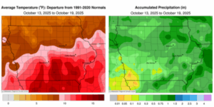
Unseasonable warmth persisted across the state, with the warmest conditions occurring over Iowa’s southern half, where temperatures were up to 14 degrees above normal. The statewide average temperature was 61.4 degrees, 10.4 degrees above normal. Most stations reported measurable rain, with above-normal precipitation observed across portions of eastern Iowa.
Light rain showers associated with a cold front crossed Iowa through the afternoon and evening of Sunday (12th), accompanied by blustery southeasterly winds and highs ranging from the upper 80s in the west to the mid-70s in the east. Numerous stations observed measurable totals, though most received less than 0.10 inch; Sully (Jasper County) collected 0.11 inch. Winds shifted to a northwesterly direction behind the front as clouds cleared from west to east, with Monday (13th) morning temperatures in the upper 30s in the northwest. Ahead of the front, temperatures were in the low to mid-60s under clear skies. Gusty winds persisted through the day as temperatures varied from the upper 70s in the southeast to the mid-60s in the northwest. Clouds returned to the state overnight as an upper-level disturbance transited the Upper Midwest. Showers developed across much of western Iowa, spreading into northern Iowa after sunrise on Tuesday (14th). Rainfall continued through the daylight hours, with highs in the low to mid-50s across the northern two-thirds of the state; readings were 10 to 15 degrees warmer over southern Iowa, where partly sunny conditions prevailed. Additional showers moved into west-central Iowa after midnight, advancing into central and eastern Iowa several hours later. Event rainfall totals were highest in northwest and central Iowa, with amounts exceeding 0.50 inch; three stations in Le Mars (Plymouth County) reported totals from 1.00 to 1.03 inches, and Sioux City Airport (Woodbury County) measured 0.88 inch. Scattered showers continued through Wednesday (15th) over much of northern Iowa, accompanied by easterly winds and daytime highs in the 50s.
Isolated thundershowers developed in the early hours of Thursday (16th) before pushing into eastern Iowa by daybreak. Northeastern stations recorded the greatest rainfall, ranging from 0.50 inch in Dubuque (Dubuque County) to 0.93 inch in Elkader (Clayton County). Stations across most of the remaining areas of the state reported amounts ranging from 0.10 to 0.30 inch. Blustery southerly winds strengthened through the afternoon, raising temperatures into the 70s under sunny skies. Light rain was reported in northwestern Iowa before sunrise on Friday (17th) as a weak cold front moved southeast across the state. A narrow line of thunderstorms developed during the late afternoon in west-central Iowa before intensifying into the evening hours. Additional and more widespread thunderstorms formed over southeastern Iowa after sunset and persisted into Saturday (18th) morning, with most stations receiving at least 0.30 inch. Burlington Municipal Airport (Des Moines County) measured 1.13 inches, and Drakesville (Davis County) reported 1.35 inches. A secondary cold front crossed the state during the remainder of the day, bringing light rain to many stations. The boundary exited the state by 7:00 a.m. on Sunday (19th) under clear skies, gusty northwesterly winds, and lows ranging from the upper 30s in the northwest to the upper 40s in the southeast. Three stations along the state line reported the highest totals, with 1.00 inch in Camanche (Clinton County) and 1.24 inches in Keokuk (Lee County).
Weekly rain totals ranged from a trace in Council Bluffs (Pottawattamie County) and Red Oak (Montgomery County) to 1.58 inches in Burlington. The statewide weekly average precipitation was 0.55 inch, compared with a normal of 0.65 inch. Little Sioux (Harrison County) reported the week’s high temperature of 87 degrees on the 12th, 21 degrees above normal. Sibley (Osceola County) recorded the week’s low temperature of 34 degrees on the 19th, one degree below normal.
(contributed press release, IDALS)