
DES MOINES, Iowa— Iowa Secretary of Agriculture Mike Naig commented on the Iowa Crop Progress and Condition Report released by the USDA National Agricultural Statistics Service. The report is released weekly April through November. Additionally, the Iowa Department of Agriculture and Land Stewardship provides a weather summary each week during this time.
“A wet start to September has helped ease drought conditions across western Iowa,” said Secretary Naig. “Another wet week ahead may limit fieldwork across much of the state. Farmers will likely use the opportunity to tackle other important work around the farm, including getting equipment ready for harvest.”
Crop Report
There were 4.5 days suitable for fieldwork during the week ending Sept. 13, 2026. This is 2.0 days less than last year, when there were 6.5 days suitable for fieldwork. Topsoil moisture condition rated 1 percent very short, 12 percent short, 80 percent adequate, and 7 percent surplus. Subsoil moisture condition rated 3 percent very short, 19 percent short, 73 percent adequate, and 5 percent surplus. Eighty-nine percent of corn reached the dent stage, which is on par with last year. Thirty-eight percent of corn has reached maturity, which is 7 percentage points behind last year. Two percent of corn has been harvested, which is 1 percentage point behind last year. Corn condition rated 76 percent good to excellent. Twenty-two percent of soybeans are dropping leaves, which is 10 percentage points behind last year. Soybean condition rated 74 percent good to excellent. Pasture condition rated 64 percent good to excellent.
The weekly report is also available on the USDA’s website at  https://www.nass.usda.gov/.
Weather Summary
Provided by Justin Glisan, Ph.D., State Climatologist, Iowa Department of Agriculture and Land Stewardship
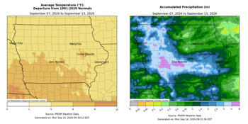
Exceedingly wet conditions were reported across broad swaths of Iowa with numerous stations observing 400-600% of normal rainfall through the reporting period. Warm temperatures also persisted with positive departures in the six to nine degree range over southern Iowa; the statewide average temperature was 71.2 degrees, 5.5 degrees above normal.
Sluggish thunderstorms in northwestern Iowa expanded south and east into Sunday (6th) afternoon, covering much of the state’s central one-third. Much of the complex dissipated into the evening hours, though another line of thunderstorms formed in western Iowa in the overnight hours of Monday (7th). This line moved slowly into central Iowa and dissipated after noon. Much of western Iowa received at least 0.50 inch with multiple stations in west-central Iowa collecting 2.00 to 4.00 inches; Greenfield (Adair County) reported 3.02 inches with 4.18 inches in Corning (Adams County) and 4.79 inches in Guthrie Center (Guthrie County). Afternoon conditions were pleasant as clouds cleared with temperatures in the upper 70s and low 80s with southeasterly winds. Cloud cover increased over northwestern Iowa into the early hours of Tuesday (8th) as a cold front entered the state. Showers and thunderstorms moved over northern Iowa throughout the day as the front sagged from the southwest to northeast. A stationary front farther south slowed the advance of the cold front, funneling anomalous atmospheric moisture from west-central to central Iowa. Training thunderstorms brought significant rainfall totals to numerous stations along with severe-warned thunderstorms, producing swaths of wind damage in Polk County. Numerous flash flood warnings were issued as the line slowly approached the Iowa-Missouri border by Wednesday (9th) morning. Nearly 100 stations recorded at least 2.00 inches with nearly 20 stations above 4.00 inches in central Iowa; Clive (Dallas County) reported 4.10 inches with 5.21 inches in Norwalk (Warren County) and 5.87 inches in Des Moines (Polk County). The statewide average rainfall was 1.40 inches, more than 0.50 inch above the weekly 30-year climatological average. With full frontal passage through the daylight hours, temperatures held in the upper 70s and low 80s with light west-northwesterly winds and some lingering clouds over the state’s southern quarter.
Thursday (10th) dawned clear with variable wind direction from west to east and a range of temperatures from low 50s north to mid 60s south. Afternoon highs rose nicely into the low 80s across the state with lower relative humidity and ample sunshine. Starry skies were visible into Friday (11th) morning with morning lows in the 50s and a shift to a southerly wind direction. Daytime temperatures returned to the lower 80s as wind speeds increased northwest as a quick-moving cold front dropped through the state. Several stations observed rainfall from thundershowers that formed along the surface front after sunset with general totals under 0.20 inch; Westfield (Plymouth County) collected 0.51 inch from a more organized storm. Winds shifted to the northwest into Saturday (12th) with pleasant daylight temperatures in the 70s under mostly sunny skies. Scattered showers developed across western Iowa after midnight with morning temperatures in the mid to upper 50s.
Weekly precipitation totals ranged from 0.23 inch in Nora Springs (Floyd County) to 7.76 inches in Guthrie Center. The statewide weekly average rainfall was 2.05 inches, more than double the normal of 0.84 inch. Shenandoah (Page County) reported the week’s high temperature of 100 degrees on the 8th, 19 degrees above normal. Spencer Municipal Airport (Clay County) reported the week’s low temperature of 44 degrees on the 24th, seven degrees below normal.

(contributed press release, IDALS)
About the Author