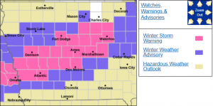
DES MOINES, Iowa—The National Weather Service Office in Des Moines has issued a Winter Strom Warning that includes Boone County.
According to the forecast report:
.Precipitation will spread from western into central Iowa this
afternoon and evening. Initially, it may begin as a
rain/snow mix across southern and western Iowa before changing to
snow. A band of 5 to 8 inches of snow is expected by Friday morning
from western through central to northeastern Iowa. There will be a
sharp gradient of snowfall on either side of the heaviest band of
snow. Snow rates may exceed 1″ per hour at times this evening
leading to rapid snow accumulations on roads and slick travel
conditions. A small change in the location of the band could alter
forecast snow amounts.
…WINTER STORM WARNING IN EFFECT FROM 6 PM THIS EVENING TO 6 AM CST
FRIDAY…
* WHAT…Heavy snow expected. Total snow accumulations between 5 and
8 inches.
* WHERE…Portions of central to northeastern Iowa.
* WHEN…From 6 PM this evening to 6 AM CST Friday.
* IMPACTS…Travel could be very difficult. The hazardous conditions
could impact the Thursday evening commute.
PRECAUTIONARY/PREPAREDNESS ACTIONS…
If you must travel, keep an extra flashlight, food, and water in
your vehicle in case of an emergency.
For the latest travel conditions, check the Iowa 511 app,
www.511ia.org, or dial 511.