DES MOINES, Iowa—Iowa Secretary of Agriculture Mike Naig commented on the Iowa Crop Progress and Condition Report released by the USDA National Agricultural Statistics Service. The report is released weekly April through November. Additionally, the Iowa Department of Agriculture and Land Stewardship provides a weather summary each week during this time.
“Severe thunderstorms early last week gave way to a cooler and quieter string of days as corn pollination is underway across the state,” said Secretary Naig. “Temperatures look to warm up through the week for county fairgoers.”
The weekly report is also available on the USDA’s website at nass.usda.gov.
Crop Report
Most of the State received little rainfall and experienced below average temperatures. These conditions allowed Iowa farmers 5.9 days suitable for fieldwork during the week ending July 21, 2024, according to the USDA, National Agricultural Statistics Service. Field activities included harvesting oats for grain, cutting and baling hay, and applying fungicides.
Topsoil moisture condition rated 1 percent very short, 10 percent short, 81 percent adequate and 8 percent surplus. Subsoil moisture condition rated 1 percent very short, 10 percent short, 80 percent adequate and 9 percent surplus.
Corn silking reached 68 percent, 1 day behind last year but 2 days ahead of the five-year average. Corn crop at the dough stage reached 18 percent, 2 days ahead of last year and 5 days ahead of the five-year average. Corn condition was rated at 75 percent good to excellent. Soybean crop blooming reached 69 percent, 5 days behind last year but equal to the five-year average. Soybeans setting pods reached 25 percent, 2 days behind last year and 1 day behind the five-year average. Soybean condition was 74 percent good to excellent. Oats turning color reached 89 percent, 2 days behind last year but 3 days ahead of the five-year average. The oat harvest for grain reached 44 percent complete, 5 days ahead of last year and the five-year average. Oat condition was 76 percent good to excellent.
The state’s second cutting of alfalfa hay reached 75 percent complete, 5 days behind last year but 2 days ahead of the five-year average. The third cutting of alfalfa hay began at 6 percent, 4 days behind last year but 1 day ahead of the five-year average. Hay condition rated 78 percent good to excellent. Pasture condition rated 71 percent good to excellent.
Weather Summary
Provided by Justin Glisan, Ph.D., State Climatologist, Iowa Department of Agriculture and Land Stewardship
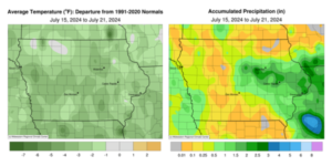
The main weather headline of the reporting period was an early week derecho that formed in central Iowa and covered over 500 miles through Illinois, Indiana and Michigan. While pockets of agricultural damage were found, particularly in eastern Iowa, most of Iowa remains free of widespread impacts. Unseasonably cool conditions were also observed statewide with negative departures in the two to four degree range; the statewide average temperature was 71.1 degrees, 2.5 degrees below normal.
Sunday (14th) afternoon was unseasonably warm statewide with daytime temperatures in the upper 80s and low 90s under mostly sunny skies. Scattered thunderstorms formed in north-central and eastern Iowa into the evening hours with some storms producing strong wind gusts. The storms dissipated just before midnight as skies cleared with a southeasterly wind into Monday (15th) morning. Lows remained warmer than normal, ranging from the upper 60s north to mid 70s south with patchy fog in northeastern Iowa. Underneath the existing heat dome over the Midwest, afternoon temperatures rose into the upper 80s to mid 90s as a boundary draped west to east became a focusing mechanism for afternoon discrete supercells. The initial storms fired in central Iowa with a fast moving EF-1 rated tornado carving a seven-mile path through the near-western suburbs of Des Moines (Polk County). The storms quickly coalesced into a squall line and sped across eastern Iowa, leaving behind nearly 50 reports of severe straight line winds and hail along with three weak tornadoes; a wind gust of 86 mph was observed near Aurora (Buchanan County). Much of the state’s eastern half reported measurable rainfall with many stations collecting at least 0.50 inch. Stations in east-central Iowa observed heavier amounts with 30 stations at or above 1.50 inches; five stations in Linn County measured more than 2.00 inches from 2.25 inches in Central City to 2.80 inches in Cedar Rapids. The line exited Iowa later in the night as skies cleared with a northwest shifting wind. Tuesday (16th) was a much quieter day with spotty showers passing across Iowa as afternoon temperatures held in the mid to upper 70s. Overnight lows into Wednesday (17th) varied from the upper 50s in northwest Iowa to mid 60s in the southeast corner. Partly cloudy skies developed through the afternoon with highs in the 70s.
Variable and light winds developed into the nighttime hours with pockets of fog reported in northern Iowa on Thursday (18th) morning. Clouds became more prevalent from west to east through the day as afternoon highs varying from the low 70s northeast to low 80s southwest. Skies cleared out across eastern Iowa into Friday (19th) with overcast conditions lingering in western Iowa where temperatures remained in the low to mid 60s; temperatures were five to 10 degrees cooler where clouds weren’t present. Cloudy conditions persisted over the daytime hours with highs holding in the 70s over much of Iowa. Showers pushed into western Iowa toward the evening and spread into central Iowa over the next several hours. Light showers increased in coverage by daybreak on Saturday (20th) with unseasonably cool conditions under stratus clouds and rain. Rainfall eventually ended around sunset with general totals in the 0.10-0.30-inch range. Higher totals were found in pockets of northern and southwest Iowa; Hampton (Franklin County) collected 0.65 inch with a 1.58 inches reading in Underwood (Pottawattamie County). Calm to light winds allowed widespread fog formation through Sunday (21st) morning with temperatures in the low to mid 60s.
Weekly precipitation totals ranged from no accumulation in several pockets to 3.66 inches in Cedar Rapids (Linn County). The statewide weekly average precipitation was 0.66 inch while the normal is 1.01 inches. Little Sioux (Harrison County) reported the week’s high temperature of 96 degrees on the 15th, 10 degrees above normal. Forest City (Winnebago County) and Mapleton (Monona County) reported the week’s low temperature of 48 degrees on the 18th, on average 14 degrees below normal.
(contributed press release, IDALS)