DES MOINIES, Iowa— Iowa Secretary of Agriculture Mike Naig commented on the Iowa Crop Progress and Condition Report released by the USDA National Agricultural Statistics Service. The report is released weekly April through November. Additionally, the Iowa Department of Agriculture and Land Stewardship provides a weather summary each week during this time.
“Combines are rolling in many areas of the state as fields are ready,” said Secretary Naig. “Though rain this past weekend may have slowed progress for some, harvest will continue ramping up throughout Iowa. The warmer and drier outlook into early October should provide an excellent window of opportunity for many farmers.”
The weekly report is also available on the USDA’s website at nass.usda.gov.
Crop Report
Iowa continued to experience hot and dry conditions this week. These conditions allowed Iowa farmers 6.3 days suitable for fieldwork during the week ending September 22, 2024, according to the USDA, National Agricultural Statistics Service. Field activities included harvesting corn and soybeans.
Topsoil moisture condition rated 9 percent very short, 41 percent short, 49 percent adequate and 1 percent surplus. Subsoil moisture condition rated 8 percent very short, 37 percent short, 54 percent adequate and 1 percent surplus.
Corn in the dent stage or beyond reached 93 percent this week. Corn mature reached 61 percent, 5 days behind last year but 2 days ahead of the average. Corn harvested for grain reached 5 percent, 5 days behind last year but equal to the average. Corn condition rated 77 percent good to excellent. Soybeans coloring or beyond reached 88 percent, 3 days behind last year but 2 days ahead of the five-year average. Soybean dropping leaves reached 59 percent, also 3 days behind last year and 2 days ahead of the average. Soybean harvested reached 9 percent this week, equal to last year but 1 day ahead of the average. Soybean condition was 78 percent good to excellent.
Pasture condition continued to fall and rated 48 percent good to excellent this week.
Weather Summary
Provided by Justin Glisan, Ph.D., State Climatologist, Iowa Department of Agriculture and Land Stewardship
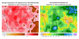
Unseasonable warmth persisted through the last week of astronomical summer with most Iowa stations reporting temperatures eight to 12 degrees above normal; the statewide average temperature was 73.1 degrees, 10.6 degrees above normal. Rainfall was below normal for the third consecutive reporting period with the driest conditions in eastern and extreme western Iowa.
Mid to upper 80s were reported across Iowa through Sunday (15th) afternoon with southerly winds and partly cloudy skies. Light showers formed in eastern Iowa towards sunset with 0.07 inch collected at Salem (Henry County). Morning lows on Monday (16th) held in the low to mid 60s with light east-southeasterly winds and generally clear skies. Daytime highs pushed back into the mid 80s with a swing back to southerly winds, becoming gusty in northwestern Iowa. Two rounds of showers moved through western Iowa overnight into Tuesday (17th) before dissipating in the late morning. Several stations in Sioux County observed measurable totals ranging from 0.13 inch at an Orange City Community Collaborative Rain, Hail and Snow (CoCoRaHS) gauge to 0.76 in Sioux Center. Spencer Municipal Airport (Clay County) reported 0.50 inches with lesser amounts at surrounding stations. Clear conditions developed into the afternoon with highs in the mid to upper 80s and stronger winds out of the south.
Wednesday (18th) morning started partly cloudy in central Iowa with lows ranging from the mid 50s east to upper 60s west. Daytime conditions were similar to the previous day with clouds building in towards the end of the day. Scattered thundershowers developed in the northwest after midnight with a second complex forming in west-central Iowa towards sunrise on Thursday (19th). Scattered showers and thunderstorms continued across portions of Iowa through the day with multiple severe-warned cells in northern and south-central Iowa. More than 30 stations observed at least an inch with central to east-central stations reporting the highest totals. Pella (Marion County) registered 1.05 inches while Davis City (Decatur County) reported 2.67 inches; the statewide average rainfall was 0.30 inch. Overnight lows into Friday (20th) fell through the low to mid 50s in western Iowa as foggy conditions developed farther east. Afternoon temperatures returned to the upper 80s and low 90s over southern Iowa with low to mid 80s north; the statewide average high was 89 degrees, 14 degrees above normal. Saturday (21st) dawned unseasonably warm with lows in the mid to upper 60s along with low 70 degree-readings along the Iowa-Missouri border. A low pressure center and its attendant cold front entered northwestern Iowa through the morning hours and continued across the state through the day. Highs ahead of the front reached into the low 90s while cooler air filtered in behind. A narrow band of thunderstorms developed along the boundary bringing widespread rainfall to the state’s southeastern half. The highest amounts were observed in the northeast and south-central portions of Iowa; 7:00 am reports on Sunday (22nd) ranged from 0.25 inch in Decorah (Winneshiek County) to 2.44 inches in Lamoni (Decatur County). Morning lows were chilly in northwest Iowa, hitting the low 40s at several locations while low to mid 60s were felt in eastern Iowa.
Weekly rain totals ranged from no accumulation at multiple eastern Iowa stations to 3.13 inches in Zearing (Story County). The statewide weekly average rain was 0.58 inch; the normal is 0.83 inch. Osceola (Clarke County) and Washington (Washington County) reported the week’s high temperature of 94 degrees on the 20th, on average 18 degrees above normal. Spencer Municipal Airport reported the week’s low temperature of 41 degrees on the 22nd, seven degrees below normal.
(contributed press release, IDALS)