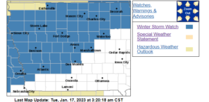
BOONE, Iowa—The National Weather Service in Des Moines has issued a Winter Storm Watch for the next round of precipitation expected Wednesday into Thursday.
URGENT - WINTER WEATHER MESSAGE
National Weather Service Des Moines IA
307 AM CST Tue Jan 17 2023

...Moderate to Heavy Snow Possible Wednesday Afternoon through
Thursday Morning...

.Snow will spread north across much of central and northern Iowa
by Wednesday afternoon. Snowfall rates may peak at 1 to 2 inches
per hour at times during the late afternoon and evening hours
Wednesday. Some minor blowing snow may occur with wind gusts in
the 20 to 25 mph range but it is not expected to be a significant
impact with this event. The precipitation may be a wintry mix or
even rain at times early in the event over parts of central Iowa,
mainly south of Interstate 80 and therefore, snowfall amounts are
less certain in these areas. The snow will gradually end from
southwest to northeast on Thursday.

...WINTER STORM WATCH IN EFFECT FROM WEDNESDAY AFTERNOON THROUGH
THURSDAY MORNING...

* WHAT...Moderate to heavy snow possible. Total snow
  accumulations of 4 to 9 inches with the greatest amounts along
  and north of a Waterloo to Ames to Atlantic line. Minor ice
  accumulations are possible over the far south edge of the
  watch..

* WHERE...Parts of central and north central Iowa.

* WHEN...From Wednesday afternoon through Thursday morning.

* IMPACTS...Travel could be very difficult. The hazardous
  conditions will impact the Wednesday evening commute.

PRECAUTIONARY/PREPAREDNESS ACTIONS...

Monitor the latest forecasts for updates on this situation.
(contributed information, NWS)