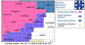
DES MOINES, Iowa—As expected, the National Weather Service has upgraded the Winter Storm Watch to a Winter Storm Warning in effect Wednesday at noon until Thursday morning at 9:00.
URGENT - WINTER WEATHER MESSAGE
National Weather Service Des Moines IA
309 PM CST Tue Jan 17 2023

...Moderate to Heavy Snow along with Mixed Precipitation
Wednesday morning through Thursday Morning...

.A wintry mix of snow, sleet, and freezing rain will spread
northward across much of southern and central Iowa by Wednesday
afternoon, becoming all snow across northern Iowa. Snowfall rates
may peak at 1 to 2 inches per hour at times during the late
afternoon and evening hours Wednesday, mainly across central and
northern Iowa. Storm total snow amounts of 5 to 9 inches are
likely in Winter Storm Warning, with lesser amounts along and
south of Interstate 80. A light glazing of ice is also possible.
Some minor blowing snow may occur with wind gusts in the 20 to 25
mph range but it is not expected to be a significant impact with
this event. The snow will gradually end from southwest to
northeast on Thursday.


...WINTER STORM WARNING IN EFFECT FROM NOON WEDNESDAY TO 9 AM CST
THURSDAY...

* WHAT...Moderate to heavy snow with a period of mixed
  precipitation expected. Total snow accumulations of 5 to 9
  inches, with the heaviest snow north of a Waterloo, to Ames, to
  Atlantic line. Light ice accumulations possible in central
  Iowa.

* WHERE...Portions of central and north-central Iowa.

* WHEN...From noon Wednesday to 9 AM CST Thursday.

* IMPACTS...Travel could be very difficult. The hazardous
  conditions could impact the evening commute on Wednesday and
  morning commute on Thursday.

PRECAUTIONARY/PREPAREDNESS ACTIONS...

If you must travel, keep an extra flashlight, food, and water in
your vehicle in case of an emergency.

For the latest travel conditions, check the Iowa 511 app,
www.511ia.org, or dial 511.
(contributed information, NWS)