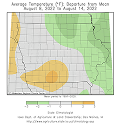
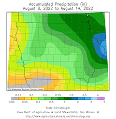
DES MOINES, Iowa—Iowa Secretary of Agriculture Mike Naig commented today on the Iowa Crop Progress and Condition Report released by the USDA National Agricultural Statistics Service. The report is released weekly April through November.“With the Iowa State Fair in full swing, a notable shift in the weather has brought cooler conditions statewide and rainfall to portions of western Iowa,” said Secretary Naig. “The weather outlook through the end of August shows moderating temperatures with additional chances of precipitation. Farmers should also see periods of drier conditions, which will allow for cover crop seeding.”The weekly report is also available on the USDA’s website at nass.usda.gov.Crop ReportWidely scattered rain across the State resulted in 5.8 days suitable for fieldwork during the week ending August 14, 2022, according to the USDA National Agricultural Statistics Service. Dry conditions continued to stress crops and pastures. Fieldwork included harvesting corn for silage and cutting hay.Topsoil moisture condition rated 24 percent very short, 29 percent short, 44 percent adequate and 3 percent surplus. The shortage of moisture was evident with over half of the topsoil considered short to very short in the Northwest, West Central, Central, Southwest, South Central and Southeast Districts. Subsoil moisture condition rated 23 percent very short, 32 percent short, 43 percent adequate and 2 percent surplus.Corn silking or beyond was 96 percent, 6 days behind last year and 5 days behind the 5-year average. Seventy two percent of the corn crop has reached the dough stage or beyond, 3 days behind last year but 1 day ahead of the average. Fifteen percent of Iowa’s corn crop has reached the dent stage, 4 days behind last year and 1 day behind the 5-year average. Corn condition dropped to 66 percent good to excellent, 7 percentage points below the previous week. Ninety-four percent of soybeans were blooming, 12 days behind last year and 3 days behind average. Eighty percent of the soybean crop was setting pods, 8 days behind last year and 2 days behind the 5 year average. Soybeans began coloring at 1 percent, equal to last year and the 5-year average. Iowa’s soybean condition fell to 63 percent good to excellent, 8 percentage points lower than the previous week. Oats harvested for grain reached 86 percent, 6 days behind both last year and the average.Ninety-seven percent of the State’s second cutting of alfalfa hay was complete, with the third cutting at 40 percent. All hay condition declined to 46 percent good to excellent. Pasture condition rated just 32 percent good to excellent. Some producers are feeding hay and hauling water to livestock.Weather SummaryProvided by Justin Glisan, Ph.D., State Climatologist, Iowa Department of Agriculture and Land StewardshipThe Iowa State Fair opened towards the tail end of the reporting period with unseasonably dry conditions across much of Iowa; northeastern stations reported above-average rainfall while deficits approaching an inch were observed over the rest of the state. Temperatures were below normal in eastern Iowa where cloud cover and rainfall persisted over multiple days. Southwestern Iowa was up to four degrees warmer than normal with a statewide average temperature of 71.9 degrees, 0.1 degree above normal.Scattered showers and thunderstorms continued across much of Iowa through Sunday (7th) afternoon and evening. A few isolated cells were severe-warned in central and east-central Iowa with heavier downpours reported. More persistent cells formed in eastern Iowa overnight into Monday (8th) before dissipating during the late morning hours. Event rain totals were highest across pockets of western and east-central Iowa with nearly 30 stations measuring at least an inch. Stations in Clinton, Jackson and Jones counties observed over two inches with Anamosa (Jones County) reporting 3.41 inches; the statewide average rainfall was 0.37 inch. Wind shifted to a northerly direction through the day with clearing skies and high temperatures in the mid 70s north to low 80s south. Variable winds built in overnight into Tuesday (9th) with foggy conditions reported at several stations. Morning lows bottomed out in the 50s with the coolest conditions in northwestern Iowa. Mostly sunny skies reigned through the afternoon hours with seasonal daytime highs in the upper 70s and low 80s. Overnight lows on Wednesday (10th) were in the upper 50s and low 60s with calm to very light winds. Daytime temperatures rebounded into the low 90s in western Iowa with low 80s reported in eastern Iowa. Cloud cover pushed into northern Iowa after midnight and held temperatures in the upper 60s; upper 50s and low 60s were observed in southern Iowa.Thursday (11th) marked the beginning of the Iowa State Fair and temperatures in Polk County were in the mid to upper 80s. A narrow line of thunderstorms formed in north-central Iowa and pushed southeast through east-central Iowa into the afternoon. A severe-warned thunderstorm dropped nickel to quarter-size hail on Zearing (Story County), producing isolated crop damage. Stations receiving rain registered totals generally under 0.30 inch with higher totals under slower-moving thunderstorms; Iowa Falls (Hardin County) observed 0.52 inch while Lake Mills (Winnebago County) measured 1.80 inches. Additional thundershowers spun into northeastern Iowa overnight into Friday (12th) and remained for much of the day. Under cloud cover, daytime highs hovered in the upper 60s with upper 80s and low 90s over western Iowa where sunshine and southerly winds boosted temperatures. Rain totals reported at 7:00 am on Saturday (13th) were mostly under 0.20 inch though Calmar (Winneshiek County) reported 1.06 inches. A cold front dove southeast through Iowa over the daylight hours, ushering in cloud cover and cooler temperatures; afternoon highs were in the upper 80s ahead of the front and upper 70s behind. A few thunderstorms popped up along the boundary early in the day in extreme northeastern Iowa but fizzled after a few hours. Overcast skies remained into Sunday (14th) morning holding temperatures in the 60s across much of the state, though low 50s were reported northwest.Weekly precipitation totals ranged from no accumulation at multiple western and southern Iowa stations to 3.67 inches in Anamosa. The statewide weekly average precipitation was 0.43 inch while the normal is 0.95 inch. Indianola (Mahaska County) and Oskaloosa (Warren County) reported the week’s high temperature of 99 degrees on the 7th, on average 14 degrees above normal. Anamosa (Jones County) reported the week’s low temperature of 47 degrees on the 10th, 14 degrees below normal.


(contributed press release)


