
DES MOINES, Iowa—Iowa Secretary of Agriculture Mike Naig commented on the Iowa Crop Progress and Condition Report released by the USDA National Agricultural Statistics Service. The report is released weekly April through November. Additionally, the Iowa Department of Agriculture and Land Stewardship provides a weather summary each week during this time.
“Nearly all of Iowa’s corn and soybeans are now planted, thanks to warm and dry conditions across much of the state over the last week,” said Secretary Naig. “As we turn the calendar to June, forecasts indicate that warmer temperatures will stick around along with a shift to better chances of rainfall. Farmers will welcome the rain, which will help recently planted crops get off to a strong start and become well established.”
Crop Report
There were 5.7 days suitable for fieldwork during the week ending May 31, 2026. This is 0.3 days more than last year, when there were 5.4 days suitable for fieldwork. Topsoil moisture condition rated 3 percent very short, 28 percent short, 64 percent adequate, and 5 percent surplus. Subsoil moisture condition rated 3 percent very short, 25 percent short, 66 percent adequate, and 6 percent surplus.
Corn planting in Iowa reached 97 percent complete, which is the same as last year’s pace. Corn emergence reached 87 percent, which is 2 percentage points ahead of last year, when 85 percent of the crop had emerged. Corn condition rated 82 percent good to excellent. Ninety-five percent of the expected soybean crop has been planted, which is unchanged from last year. Soybean emergence reached 74 percent, which is 2 percentage points behind last year. Soybean condition rated 79 percent good to excellent. Ninety-eight percent of the state’s oat crop has emerged, 3 percentage points ahead of last year. Oats headed reached 35 percent, 4 percentage points behind last year. Oats condition rated 85 percent good to excellent. Pasture condition rated 75 percent good to excellent.
The weekly report is also available on the USDA’s website at https://www.nass.usda.gov/.
Weather Summary
Provided by Justin Glisan, Ph.D., State Climatologist, Iowa Department of Agriculture and Land Stewardship
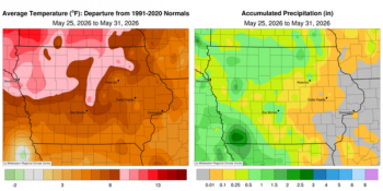
The last week of May was unseasonably warm and dry with most Iowa stations reporting rainfall deficits; stations in eastern Iowa reported no measurable totals. Temperatures were the warmest from northwest to north-central Iowa where readings were nine to 12 degrees above normal; the statewide average temperature was 73.2 degrees, 8.7 degrees above normal.
Sunday (24th) afternoon was unseasonably warm with temperatures in the low to mid 80s with gusty southerly winds and sunny skies. Strong to severe thunderstorms fired across northwestern Iowa after sunset with some cells producing 1.00 to 1.25 inch diameter hail in Alvord (Lyon County) and Sanborn (O’Brien County). Showers and thunderstorms continued across northern Iowa into the early hours of Monday (25th). Many stations reported a few tenths of an inch with 1.10 inches in Rock Rapids (Lyon County) and 1.22 inches in Sheldon (O’Brien County). Very windy conditions developed through Memorial Day with afternoon highs pushing into the mid to upper 80s under sunshine and low humidity; the statewide average high was 86 degrees, 12 degrees above normal. Scattered thunderstorms formed across north-central Iowa before midnight, pushing slowly east until they dissipated after sunrise on Tuesday (26th). Three stations in Osage (Mitchell County) received the highest totals ranging from 0.97 to 1.63 inches; other stations reporting measurable totals collected totals from 0.10 to 0.25 inch. The daytime hours were again warm with sunny skies and temperatures from low 80s southeast to low 90s northwest. Winds became light and variable into early Wednesday (27th) with overnight rainfall from isolated showers; Elma (Howard County) registered 0.26 inch. Afternoon conditions were similar to the previous day with rare lenticular clouds between Des Moines (Polk County) and Ames (Story County) produced by a northward propagating gravity wave.
Thursday (28th) dawned with easterly winds, clear skies and morning temperatures in the low to mid 60s. Afternoon highs returned to the 80s with dew points holding in the 50s over much of the state. A low pressure center over Kansas spun showers into southwest Iowa later in the afternoon and continued into Friday (29th). Oakland (Pottawattamie County) observed 0.96 inch while 2.20 inches was reported in Hastings (Mills County). Totals generally under 0.20 inch were found across the western half of the state while eastern Iowa remained dry. Temperatures in southwest Iowa held in the low 70s where rain was falling with low to mid 80s east. Showers pushed into northwest Iowa on Saturday (30th) morning as the southern branch dissipated. Winds shifted southeasterly into the afternoon with temperatures varying from the mid 60s northwest to low 80s southeast, where skies were mostly sunny. More widespread showers and thunderstorms formed across western Iowa after midnight and expanded through the state. Many stations in western Iowa reported at least 0.50 inch with locally heavier amounts in the southwest corner. Council Bluffs (Pottawattamie County) reported 1.07 inches while Shenandoah (Page County) collected 2.02 inches.
Weekly precipitation totals ranged from no accumulation across eastern Iowa stations to 3.12 inches in Shenandoah (Page County). The statewide weekly average precipitation was 0.47 inch; the normal is 1.14 inches. Sioux City Airport (Woodbury County) reported the week’s high temperature of 95 degrees on the 25th, 19 degrees above normal. Several stations reported the week’s low temperature of 47 degrees on the 25th, on average five degrees below normal.

(contributed press release, IDALS)