

DES MOINES, Iowa—Iowa Secretary of Agriculture Mike Naig commented on the Iowa Crop Progress and Condition Report released by the USDA National Agricultural Statistics Service. The report is released weekly April through November. Additionally, the Iowa Department of Agriculture and Land Stewardship provides a weather summary each week during this time.
“Late summer heat along with scattered showers and thunderstorms returned to much of Iowa over the weekend and will stick around this week, with temperatures climbing into the 90s. The warm weather will continue to push crop development as we close out August and head into September,” said Secretary Naig. “We’re also looking forward to welcoming farmers, agribusiness leaders and visitors from across the country and around the world to Boone this week for the Farm Progress Show. It’s a great opportunity to showcase Iowa agriculture and share ideas while seeing some of the latest innovations and technologies shaping the future of our farms.”
Crop Report
There were 6.1 days suitable for fieldwork during the week ending Aug. 30, 2026. This is 0.2 days less than last year, when there were 6.3 days suitable for fieldwork. Topsoil moisture condition rated 3 percent very short, 24 percent short, 67 percent adequate, and 6 percent surplus. Subsoil moisture condition rated 5 percent very short, 22 percent short, 67 percent adequate, and 6 percent surplus. Ninety-four percent of Iowa’s corn crop has reached the dough stage, which is 3 percentage points ahead of last year. Sixty-eight percent of corn reached the dent stage, which is 8 percentage points ahead of last year. Six percent of corn has reached maturity, which is 2 percentage points behind last year. Corn condition rated 77 percent good to excellent. Soybeans setting pods reached 93 percent, which is 1 percentage point behind last year. One percent of soybeans are dropping leaves, which is 2 percentage points behind last year. Soybean condition rated 77 percent good to excellent. Ninety-eight percent of oats have been harvested, which is 1 percentage point behind last year. Pasture condition rated 65 percent good to excellent.
The weekly report is also available on the USDA’s website at https://www.nass.usda.gov/.
Weather Summary
Provided by Justin Glisan, Ph.D., State Climatologist, Iowa Department of Agriculture and Land Stewardship
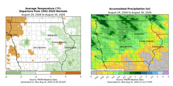
Iowans experienced a less active storm track through the reporting period. Rain fell across much of Iowa, though most stations experienced below normal amounts. Weekly temperatures varied from warmer than average in western Iowa to slightly cooler east. The statewide average temperature was 70.1 degrees, 0.8 degree above normal.
Sunday (23rd) afternoon was pleasant with mostly sunny skies and temperatures in the mid to upper 70s. Clouds increased across western Iowa into Monday (24th) morning with showers moving into the state before sunrise. The complex dissipated somewhat as it moved through central to southeastern Iowa. Totals were generally under 0.20 inch where rain fell, however a few stations from western to central Iowa collected nearly 0.50 inch; Clive (Polk County) collected 0.49 inch while Boone (Boone County) registered 0.63 inch. Clouds persisted and spread east overnight into Tuesday (25th) with morning lows holding in the upper 50s east to mid 60s west under southeasterly winds. Afternoon conditions transitioned to partly sunny as highs rose into the upper 70 and low 80s. Foggy conditions were observed over southern Iowa after sunrise on Wednesday (26th) with clear conditions farther north. Temperatures varied from the upper 50s in northern Iowa to upper 60s in the south under cloudy skies. Blustery northwesterly winds developed into the afternoon hours as a cold front transited the state with daytime highs in the upper 70s and low 80s north to south. Starry skies were visible into Thursday (27th) with light northwesterly winds and temperatures in the low 50s over northern Iowa to low 60s in the southeast corner. Mostly sunny skies continued through the daylight hours with highs returning to the upper 70s and low 80s. Clouds increased slightly into the nighttime hours, though conditions were perfect to view the deep partial lunar eclipse. Friday (28th) dawned with patchy fog and light, variable winds with morning lows in the 50s. Afternoon conditions were seasonal with temperatures in the low 80s under light southerly winds. Wind speeds increased overnight into Saturday (29th) as showers and thunderstorms moved into northwest Iowa. The shield of rain expanded across much of the state as the complex moved southeast, clearing Iowa later in the evening. A majority of Iowa’s stations reported measurable totals with the highest amounts northwest to central Iowa where amounts were above 0.50 inch; Webster City (Hamilton County) registered 0.78 inch with 1.30 inches in Rock Rapids (Lyon County) and a statewide average of 0.22 inch. The rest of the day was mostly sunny and pleasant with highs in the upper 70s. Showers and thunderstorms redeveloped in western Iowa by daybreak on Sunday (30th) with Sidney (Fremont County) reporting 0.30 inch.
Weekly precipitation totals ranged from no measurable amounts at many southern stations to 1.40 inches in Rock Rapids (Lyon County). The statewide weekly average rainfall was 0.32 inch, while the normal is 0.91 inch. Shenandoah (Page County) reported the week’s high temperature of 91 degrees, eight degrees above normal. Lake Park (Dickinson County) reported the week’s low temperature of 47 degrees on the 24th, 12 degrees below normal.

(contributed press release, IDALS)
About the Author