

DES MOINES, Iowa—Iowa Secretary of Agriculture Mike Naig commented on the Iowa Crop Progress and Condition Report released by the USDA National Agricultural Statistics Service. The report is released weekly April through November. Additionally, the Iowa Department of Agriculture and Land Stewardship provides a weather summary each week during this time.
“Weather conditions allowed Iowa farmers to make strong harvest progress last week. Soybean harvest is nearing completion in many areas and corn harvest is well beyond the halfway point,” said Secretary Naig. “Forecasts show widespread rain this week, which will help establish newly seeded cover crops. As warmer temperatures continue this fall, I encourage farmers to keep an eye on 4-inch soil temperatures and wait for ‘50 degrees and falling’ before applying anhydrous. The Iowa State University Mesonet website is an excellent resource to help farmers monitor soil temperatures in their respective counties.”
Crop Report
There were 5.1 days suitable for fieldwork during the week ending Nov. 1, 2026. Topsoil moisture condition rated 4 percent short, 80 percent adequate, and 16 percent surplus. Subsoil moisture condition rated 6 percent short, 82 percent adequate, and 12 percent surplus. Sixty-six percent of corn has been harvested, which is 13 percentage points behind the five-year average. Ninety percent of soybeans have been harvested, which is on par with the five-year average.
The weekly report is also available on the USDA’s website at https://esmis.nal.usda.gov/
Weather Summary
Provided by Justin Glisan, Ph.D., State Climatologist, Iowa Department of Agriculture and Land Stewardship
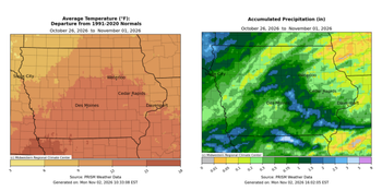
Rain was reported somewhere in Iowa every day throughout the reporting period, with the highest totals occurring in northwestern and southern Iowa. Temperatures remained well above normal across much of the southern two-thirds of the state, with positive departures ranging from 12 to 15 degrees. The statewide average temperature was 56.8 degrees, 11.8 degrees above normal.
A broad range of temperatures was reported on Sunday (25th) afternoon with 50s across the northwest corner behind a surface boundary to mid 70s southeast. Showers developed overnight into Monday (26th) in northwestern Iowa as winds shifted northeasterly. Rainfall persisted over much of Iowa’s northwestern half through the day as winds swung back to the east in advance of a low pressure system. Higher rain totals were observed far northwest with several stations collecting at least an inch; Primghar (O’Brien County) registered 1.01 inches while 1.20 inches was reported in Rock Rapids (Lyon County). Temperatures under cloud cover only made it into the mid 40s, transitioning to the 60s in central Iowa to the 70s farther southeast. The low pressure disturbance advanced northeast across western Iowa as cloud cover expanded into eastern Iowa by daybreak on Tuesday (27th). A narrow southwest to northeast oriented band of showers formed along the low’s attendant cold front before dissipating into the early afternoon hours. Rain totals were generally light, though a handful of stations saw higher totals from 0.36 inch in Audubon (Audubon County), to 0.55 inch in Fort Dodge (Webster County and 0.68 inch in Eagle Grove (Wright County).
Skies were partly to mostly cloudy at sunrise on Wednesday (28th) with morning lows in the mid to upper 40s east to mid 50s west. Gusty southerly winds helped push temperatures in the mid to upper 70s over eastern Iowa; increasing clouds in western Iowa held highs in the upper 60s and low 70s. A cold front associated with a low pressure system over Minnesota swept through Iowa into the evening and overnight hours. Showers and thunderstorms fired along the boundary as it moved into central Iowa. Most stations reported totals less than 0.20 inch with a narrow swath in the 0.30- to 0.50-inch range; a gauge in Fort Dodge registered 0.72 inch. The cold front cleared eastern Iowa a few hours before sunrise with a northerly shifting wind, clearing skies and Thursday (29th) morning lows in the mid to upper 30s northwest to upper 50s southeast. Afternoon conditions were pleasant with light winds, sunny skies and temperatures in the 60s. Showers and thunderstorms developed over southern Iowa after sunset and progressed east by Friday (30th). Pockets of additional development continued through the day and into Saturday (31st) morning. Many stations along the Iowa-Missouri border, along with a swath from central into southeastern Iowa, reported totals between 0.50 and 1.00 inch with localized heavier amounts; twenty-one stations had more than an inch, with 1.01 inches in Sully (Jasper County), 2.02 inches in Sigourney (Keokuk County), and 2.42 inches in Allerton (Wayne County). Rainfall dissipated by dusk as temperatures held in the upper 50s under cloud cover for excited trick-or-treaters. Sunday (1st) began overcast with easterly winds and lows in the 50s.
Weekly precipitation totals ranged from no measurable totals at a few northeastern stations to 2.47 inches in Allerton (Wayne County). The statewide weekly average precipitation was 0.70 inch, while the normal is 0.50 inch. Clarinda (Page County) reported the week’s high temperature of 81 degrees on the 25th, 20 degrees above normal. Spencer Municipal Airport (Clay County) reported the week’s low temperature of 33 degrees on the 29th, one degree below normal.

(contributed press release, IDALS)
About the Author